Blanzaguet-Saint-Cybard
Blanzaguet-Saint-Cybard (French pronunciation: [blɑ̃zaɡɛ sɛ̃ sibaʁ]; Occitan: Blanzaguet e Sent Cibard) is a commune in the Charente department in southwestern France.
Blanzaguet-Saint-Cybard | |
|---|---|
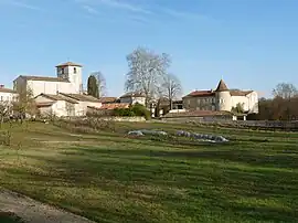 A general view of Blanzaguet | |
Location of Blanzaguet-Saint-Cybard | |
 Blanzaguet-Saint-Cybard  Blanzaguet-Saint-Cybard | |
| Coordinates: 45°28′15″N 0°19′16″E | |
| Country | France |
| Region | Nouvelle-Aquitaine |
| Department | Charente |
| Arrondissement | Angoulême |
| Canton | Tude-et-Lavalette |
| Government | |
| • Mayor (2020–2026) | Nathalie Selin[1] |
| Area 1 | 11.95 km2 (4.61 sq mi) |
| Population | 287 |
| • Density | 24/km2 (62/sq mi) |
| Time zone | UTC+01:00 (CET) |
| • Summer (DST) | UTC+02:00 (CEST) |
| INSEE/Postal code | 16047 /16320 |
| Elevation | 82–162 m (269–531 ft) (avg. 102 m or 335 ft) |
| 1 French Land Register data, which excludes lakes, ponds, glaciers > 1 km2 (0.386 sq mi or 247 acres) and river estuaries. | |
Geography
The Lizonne forms part of the commune's southeastern border.
Population
|
|
See also
References
- "Répertoire national des élus: les maires". data.gouv.fr, Plateforme ouverte des données publiques françaises (in French). 9 August 2021.
- "Populations légales 2020". The National Institute of Statistics and Economic Studies. 29 December 2022.
Wikimedia Commons has media related to Blanzaguet-Saint-Cybard.
This article is issued from Wikipedia. The text is licensed under Creative Commons - Attribution - Sharealike. Additional terms may apply for the media files.