Bingöl
Bingöl (Armenian: Ճապաղջուր, romanized: Chapaghjur, Kurdish: Çewlik,[2] Zazaki: Çewlîg[3]), known as Çapakçur before 1944, is a city in Turkey. It is the seat of Bingöl Province and Bingöl District,[4] having a population of 133,423 (2022).[1]
Bingöl | |
|---|---|
 | |
 Bingöl Location in Turkey | |
| Coordinates: 38°53′10″N 40°30′6″E | |
| Country | Turkey |
| Province | Bingöl |
| District | Bingöl |
| Government | |
| • Mayor | Erdal Arıkan (AKP) |
| Elevation | 1,120 m (3,670 ft) |
| Population (2022)[1] | 133,423 |
| Time zone | TRT (UTC+3) |
| Postal code | 12000 |
| Area code | 0426 |
| Website | www |
Etymology
One of the historical names for the city, Bingöl literally means thousand lakes in Turkish; however, there aren't any lakes of considerable size within the boundaries of the province. The name rather refers to many tarns found around the city.[5][6]
History
Bingöl is located in what was historically the region of Sophene (first an independent kingdom and later an Armenian and Roman province).[7] The settlement is mentioned by its Armenian name, Chapaghjur (meaning "spread out water" in Armenian), by the 11th-century Armenian historian Stepanos Asoghik, who mentions it while describing the 995 Balu earthquake.[7] Chapaghjur is sometimes identified with the Roman fortress-town of Citharizum (Ktʻaṛich in Armenian).[7]
In the Middle Ages, Bingöl was known as Romanoupolis (Greek: Ῥωμανούπολις) after the Byzantine emperor Romanos I Lekapenos, who incorporated it into the Byzantine Empire in 942. It initially formed a subdivision of the thema of Mesopotamia, but it was later (ca. 970) elevated into a separate theme.[8]
Bingöl was ruled by the Suwaydid dynasty, a cadet branch of the Barmakids, from the 13th century until mid-Ottoman rule, autonomously from the Ottomans.[9] Bingöl and the surrounding district had a large Armenian population prior to the Armenian genocide.[7] Until the middle of the 20th century, the city was known as Çapakçur/Çabakçur, derived from its Armenian name.[10][11] In 1944, the place was renamed Bingöl, meaning "thousand lakes" in Turkish.
Kurdish-Turkish conflict
Bingöl has been the site of several violent incidents of the Kurdish-Turkish conflict. On 23 October 2016, a car bombing targeting an armored police vehicle perpetrated by PKK militias killed 2 police officers and injured 19 others.[12] On 8 June 2018, a group of PKK militias attacked a military station and killed 1 Turkish soldier while injuring 3 others.[13]
Geography
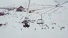
Bingöl is 144 kilometres (89 mi) east of Elazığ and is situated in the high region of Eastern Anatolia. Bingöl is a mountainous area with heights reaching 3000 m, Bingöl city is at about 1120 m above sea level.[14] The Gayt River (Gayt Çayı), a right-bank tributary of the Eastern Euphrates (Murat River), runs through the city.
Climate
Bingöl has a continental climate (Köppen climate classification: Dsa, or Trewartha climate classification: Dca), with hot, dry summers and cold, snowy winters. The driest months are July and August and the wettest is February and December.
| Climate data for Bingöl (1991–2020, extremes 1961–2020) | |||||||||||||
|---|---|---|---|---|---|---|---|---|---|---|---|---|---|
| Month | Jan | Feb | Mar | Apr | May | Jun | Jul | Aug | Sep | Oct | Nov | Dec | Year |
| Record high °C (°F) | 13.3 (55.9) |
16.2 (61.2) |
22.3 (72.1) |
30.3 (86.5) |
33.9 (93.0) |
38.0 (100.4) |
42.0 (107.6) |
41.3 (106.3) |
37.8 (100.0) |
32.1 (89.8) |
25.5 (77.9) |
22.8 (73.0) |
42.0 (107.6) |
| Average high °C (°F) | 2.4 (36.3) |
4.1 (39.4) |
10.2 (50.4) |
16.9 (62.4) |
23.1 (73.6) |
29.8 (85.6) |
34.7 (94.5) |
35.1 (95.2) |
29.9 (85.8) |
22.0 (71.6) |
12.7 (54.9) |
5.2 (41.4) |
18.8 (65.8) |
| Daily mean °C (°F) | −2.1 (28.2) |
−0.8 (30.6) |
4.7 (40.5) |
10.9 (51.6) |
16.2 (61.2) |
22.2 (72.0) |
26.7 (80.1) |
26.7 (80.1) |
21.3 (70.3) |
14.5 (58.1) |
6.8 (44.2) |
0.7 (33.3) |
12.3 (54.1) |
| Average low °C (°F) | −5.5 (22.1) |
−4.6 (23.7) |
0.4 (32.7) |
5.8 (42.4) |
10.2 (50.4) |
15.0 (59.0) |
19.3 (66.7) |
19.1 (66.4) |
13.9 (57.0) |
8.6 (47.5) |
2.2 (36.0) |
−2.8 (27.0) |
6.8 (44.2) |
| Record low °C (°F) | −23.2 (−9.8) |
−21.6 (−6.9) |
−20.3 (−4.5) |
−9.2 (15.4) |
1.0 (33.8) |
3.5 (38.3) |
8.8 (47.8) |
7.8 (46.0) |
4.2 (39.6) |
−2.4 (27.7) |
−15.0 (5.0) |
−25.1 (−13.2) |
−25.1 (−13.2) |
| Average precipitation mm (inches) | 138.7 (5.46) |
128.9 (5.07) |
134.4 (5.29) |
110.5 (4.35) |
82.5 (3.25) |
21.3 (0.84) |
6.6 (0.26) |
5.1 (0.20) |
15.4 (0.61) |
65.3 (2.57) |
93.1 (3.67) |
133.3 (5.25) |
935.1 (36.81) |
| Average precipitation days | 10.47 | 10.37 | 13.43 | 15.17 | 14.50 | 5.70 | 1.93 | 1.57 | 3.33 | 8.33 | 8.47 | 11.30 | 104.6 |
| Mean monthly sunshine hours | 105.4 | 124.3 | 148.8 | 165.0 | 213.9 | 270.0 | 285.2 | 275.9 | 240.0 | 189.1 | 135.0 | 102.3 | 2,254.9 |
| Mean daily sunshine hours | 3.4 | 4.4 | 4.8 | 5.5 | 6.9 | 9.0 | 9.2 | 8.9 | 8.0 | 6.1 | 4.5 | 3.3 | 6.2 |
| Source: Turkish State Meteorological Service[15] | |||||||||||||
Earthquakes
On 1 May 2003 the whole area suffered from a magnitude 6.4 earthquake, leaving 176 dead and 520 injured.[16] On 8 March 2010, the area suffered another earthquake, of magnitude 5.9, with its epicenter in Elazığ Province, 45 km (28 mi) west of Bingöl. On 14 June 2020, a relatively small earthquake occurred in the region, killing a village guard and injuring 21 others.[17]
Demographics
Ethnic background
In 1891, the kaza had 20,800 inhabitants: 16,465 Muslims and 4,385 Armenians.[18]
| Turkish | Arabic | Kurdish | Circassian | Armenian | Unknown or other languages |
|---|---|---|---|---|---|
| 975 | 1 | 9,416 | – | – | – |
| Muslim | Armenian | Orthodox | Other Christian |
|---|---|---|---|
| 10,395 | – | – | – |
Population
|
| |||||||||||||||||||||||||||||||||||||||
| Source: Population censuses (1965-1997)[20][21][22][23][24][25][26] and TÜIK (2007-2022)[1] | ||||||||||||||||||||||||||||||||||||||||
Transport
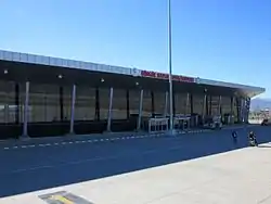
Bingöl Airport opened on 12 July 2013. It has a passenger capacity of 500'000 a year.
Education
Bingöl University opened on 29 May 2007.[27] The University continues its activities with 9 faculties, 6 vocational schools and 5 institutes.
References
- "Population Of Municipalities, Villages And Quarters". TÜIK. Retrieved 24 March 2023.
- Adem, Avcıkıran (2009). Kürtçe Anamnez Anamneza bi Kurmancî (in Turkish and Kurdish). p. 55.
- Ferhengê Kirmanckî (Zazakî)-Tirkî: Kırmancca (Zazaca)-Türkçe Sözlük (in Turkish and Zazaki). Weşanxaneyê Vateyî. 2009. p. 106. ISBN 978-975-6278-40-6.
- İlçe Belediyesi, Turkey Civil Administration Departments Inventory. Retrieved 30 January 2023.
- "Coğrafi Yapı". www.bintso.org.tr. Retrieved 17 October 2022.
- Evliyâ Çelebi Seyahatnâmesi: III. pp. 240–241. Retrieved 17 October 2022.
- Hakobyan, Tadevos Kh.; Melik-Bakhshyan, Stepan T.; Barseghyan, Hovhannes Kh. (1991). Հայաստանի և հարակից շրջանների տեղանունների բառարան [Dictionary of toponymy of Armenia and adjacent territories] (in Armenian). Vol. 3. Yerevan: Yerevan State University Publishing House. p. 603.
- Oikonomides, Nicolas (1972). Les Listes de Préséance Byzantines des IXe et Xe Siècles (in French). Paris, France: Editions du Centre National de la Recherche Scientifique. p. 359.
- M. Mahfuz, Söylemez (2010). According To The Tahrir Register Dated 1550 Liva Of Çapakçur (PDF). Bingöl. p. 17. ISBN 978-975-6788-82-0. Archived from the original (PDF) on 27 June 2020.
{{cite book}}: CS1 maint: location missing publisher (link) - Italian City-states and Catholic Missions in Mongolian World of the 13th and 14th Centuries, ANTHROPOLOGIA INTEGRA Vol. 3, No. 2, 2012, p.9; academia.edu
- Bingöl Tarihi, frmartuklu.org
- "Bingöl'de zırhlı polis aracına saldırı: 2 polis şehit, 5'i polis 19 yaralı". www.sozcu.com.tr (in Turkish). 23 October 2016. Retrieved 28 October 2020.
- DHA (8 June 2018). "Bingöl'de PKK pususu: 1 asker şehit, 3 asker yaralı". Hürriyet (in Turkish). Retrieved 28 October 2020.
- Aydan, Ö. (July 2003). "THE BİNGÖL EARTHQUAKE OF MAY 1, 2003" (PDF). Tokai University, Department of Marine Civil Engineering. p. 4.
- "Resmi İstatistikler: İllerimize Ait Mevism Normalleri (1991–2020)" (in Turkish). Turkish State Meteorological Service. Retrieved 27 June 2021.
- Aydan, Ö. (July 2003). "THE BİNGÖL EARTHQUAKE OF MAY 1, 2003" (PDF). Tokai University, Department of Marine Civil Engineering. p. 1.
- "Bingöl'de deprem: Bir güvenlik görevlisi hayatını kaybetti". euronews (in Turkish). 15 June 2020. Retrieved 21 October 2020.
- "Kaza Chapaghjur – Ճապաղջուր". Virtual Genocide Memorial. Retrieved 17 September 2023.
- Sertel, Savaş (1 January 2014). "ERKEN CUMHURİYET DÖNEMİNDE BİNGÖL NÜFUSU". XVII. TTK Bildiri Kitabi.
- "1965 General Census" (PDF) (in Turkish). Turkish Statistical Institute. 1965. Archived (PDF) from the original on 31 May 2022.
- "1970 General Census" (PDF) (in Turkish). Turkish Statistical Institute. 1970. Archived (PDF) from the original on 10 August 2022.
- "1975 General Census" (PDF) (in Turkish). Turkish Statistical Institute. 1975. Archived (PDF) from the original on 10 August 2022.
- "1980 General Census" (PDF) (in Turkish). Turkish Statistical Institute. 1980. Archived (PDF) from the original on 17 June 2022.
- "1985 General Census" (PDF) (in Turkish). Turkish Statistical Institute. 1986. Archived (PDF) from the original on 22 May 2021.
- "1990 General Census" (PDF) (in Turkish). Turkish Statistical Institute. 1991. Archived (PDF) from the original on 31 August 2021.
- "1997 Population Count" (PDF) (in Turkish). Turkish Statistical Institute. 1999. Archived (PDF) from the original on 30 October 2022.
- Bingöl University Archived 11 June 2015 at the Wayback Machine