Bayswater Road, Sydney
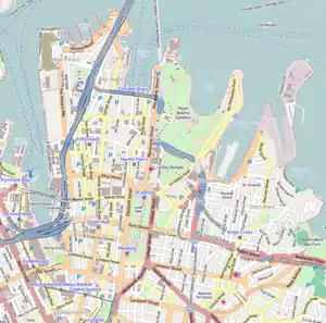
Bayswater Road is a 700-metre-long (2,300 ft)[1] minor street in the Kings Cross district of Sydney, New South Wales, Australia.
Bayswater Road | |
|---|---|
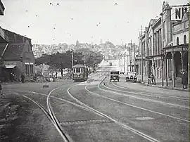 | |
| Bayswater Road in Kings Cross in 1929 | |
 West end East end | |
| Coordinates |
|
| General information | |
| Type | Street |
| Length | 700 m (0.4 mi)[1] |
| Gazetted | December 1964[2] |
| Former route number | (through Rushcutters Bay) |
| Major junctions | |
| West end | Darlinghurst Road Potts Point, Sydney |
| William Street | |
| East end | New South Head Road Rushcutters Bay, Sydney |
Route
Bayswater Road commences at the intersection with Darlinghurst Road in Potts Point and heads east over a short rise and down a hill towards Rushcutters Bay where, east of Ward Avenue and west of Roslyn Street, vehicular traffic in the street able to head in one way direction, from west to east only. At Roslyn Street, through traffic is not permitted, with all traffic directed north on Roslyn Street. East of the junction of Roslyn Street and Bayswater Road, southbound traffic on Roslyn Street is also directed one way, east, on Bayswater Road. From this point Bayswater Road merges with William Street and, adjacent to Rushcutters Bay Park, the street continues as New South Head Road.[1]
The western end of the street is lined with nightspots, eateries, adult venues, dance clubs hotels, and is a popular destination for both Sydneysiders and tourists. It is considered to be a more upmarket precinct of Kings Cross, when compared with Darlingurst Road.
History
The passing of the Main Roads Act of 1924[3] through the Parliament of New South Wales provided for the declaration of Main Roads, roads partially funded by the State government through the Main Roads Board (later the Department of Main Roads, and eventually Transport for NSW). With the subsequent passing of the Main Roads (Amendment) Act of 1929[4] to provide for additional declarations of State Highways and Trunk Roads, the Department of Main Roads (having succeeded the MRB in 1932) extended the western end of Main Road 173 from New South Head Road further west along Bayswater Road to William Street (and continuing west along William Street towards Woolloomooloo) on 2 December 1964.[2]
The passing of the Roads Act of 1993[5] updated road classifications and the way they could be declared within New South Wales. Under this act, William Street retains its declaration as part of Main Road 173.[6]
The route was allocated State Route 76 through Rushcutters Bay in 1976, after the opening of the Kings Cross Tunnel, but was completely decommissioned in 2004.
A busy electric tramway to Watsons Bay once ran down the thoroughfare, this was closed in 1960, replaced by buses.[7]
Major intersections
| LGA | Location | km[1] | mi | Destinations | Notes |
|---|---|---|---|---|---|
| Sydney | Potts Point | 0.0 | 0.0 | Darlinghurst Road – Kings Cross, Darlinghurst | Western terminus of road |
| Rushcutters Bay | 0.3 | 0.19 | Roslyn Street (one-way southbound) – Kings Cross | ||
| Rushcutters Bay–Darlinghurst boundary | 0.4 | 0.25 | William Street (one-way eastbound) – Rushcutters Bay | Eastbound traffic from Kings Cross Tunnel only | |
| 0.6 | 0.37 | MacLachlan Avenue (one-way northbound) – Darlinghurst | |||
| Sydney–Woollahra boundary | Rushcutters Bay–Darling Point–Edgecliff tripoint | 0.7 | 0.43 | Neild Avenue (one-way southbound) – Darlinghurst | |
| New South Head Road – Double Bay, Vaucluse, Watsons Bay | Eastern terminus of road | ||||
| |||||
References
- Google (31 May 2023). "Bayswater Road" (Map). Google Maps. Google. Retrieved 31 May 2023.
- "Main Roads Act, 1924-1963". Government Gazette of the State of New South Wales. No. 137. National Library of Australia. 4 December 1964. p. 3910. Archived from the original on 15 May 2023. Retrieved 31 May 2023.
- State of New South Wales, An Act to provide for the better construction, maintenance, and financing of main roads; to provide for developmental roads; to constitute a Main Roads Board Archived 11 August 2022 at the Wayback Machine 10 November 1924
- State of New South Wales, An Act to amend the Main Roads Act, 1924-1927; to confer certain further powers upon the Main Roads Board; to amend the Local Government Act, 1919, and certain other Acts; to validate certain payments and other matters; and for purposes connected therewith. Archived 12 August 2022 at the Wayback Machine 8 April 1929
- State of New South Wales, An Act to make provision with respect to the roads of New South Wales; to repeal the State Roads Act 1986, the Crown and Other Roads Act 1990 and certain other enactments; and for other purposes. Archived 11 August 2022 at the Wayback Machine 10 November 1924
- Transport for NSW (August 2022). "Schedule of Classified Roads and Unclassified Regional Roads" (PDF). Government of New South Wales. Archived from the original (PDF) on 25 August 2022. Retrieved 1 August 2022.
- Keenan, D. (1979), Tramways of Sydney. Transit Press: Sydney, p. 2