Bassari Country
The Bassari Country (French: Pays Bassari) and its Bassari, Fula and Bedik Cultural Landscapes (Paysages culturels Bassari, Peul et Bédik), located in the southeast of Senegal, is a well-preserved multicultural landscape which emerged from the interaction of human activities and the natural environment. It aggregates three geographical areas: the Bassari–Salémata area, the Bedik–Bandafassi area and the Fula–Dindéfello area, each one with its specific morphological characteristics.[1]
| UNESCO World Heritage Site | |
|---|---|
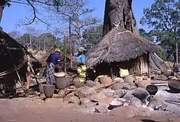 Bedik village | |
| Location | Senegal |
| Includes |
|
| Criteria | Cultural: (iii), (v), (vi) |
| Reference | 1407 |
| Inscription | 2012 (36th Session) |
| Area | 503.09 km2 (124,316 acres) |
| Buffer zone | 2,407.56 km2 (594,921 acres) |
| Coordinates | 12°35′36″N 12°50′45″W |
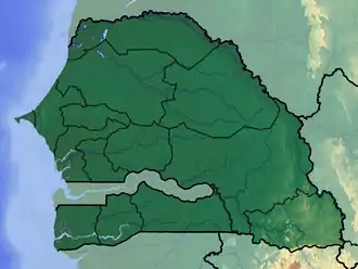 Location of Bassari Country in Senegal | |

Map of Kédougou Region; Bassari, Fula and Bedik Country are located in the Salémata Department and Kédougou Department.
In 2012, the Bassari Country with its Bassari, Fula and Bedik Cultural Landscapes was added to the UNESCO list of World Heritage Sites.[2]
See also
References
- "Bassari Country: Bassari, Fula and Bedik Cultural Landscapes". UNESCO. Retrieved 16 May 2015.
- "Twenty-six new sites inscribed on UNESCO World Heritage List this year". UNESCO. Retrieved 16 May 2015.
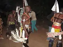
Bassari dancers in Kédougou
This article is issued from Wikipedia. The text is licensed under Creative Commons - Attribution - Sharealike. Additional terms may apply for the media files.