Barh
Barh is the oldest sub division of india. It is a town and one of the 6 sub-division of Patna District, Bihar in India. It is located on the southern bank of the Ganges.[1]
Barh | |
|---|---|
town and subdivision | |
 | |
 Barh Location in Bihar, India  Barh Barh (India) | |
| Coordinates: 25.48°N 85.72°E | |
| Country | |
| State | Bihar |
| Division | Patna |
| District | Barh |
| Government | |
| • Body | Nagar Parishad |
| Area | |
| • Total | 98,000 km2 (38,000 sq mi) |
| Elevation | 47 m (154 ft) |
| Population (2011) | |
| • Total | Approx 10 lakhs in district |
| Demonym | Barh |
| Languages | |
| • Official | Magahi, Hindi |
| Time zone | UTC+5:30 (IST) |
| PIN | 803212,803213,803214 |
| Telephone code | 06132 |
| Vehicle registration | BR-01 |
| Website | patna |
Population
According to the 2011 Census of India, Barh had a total population of 316,348 residents, with 162,354 males and 153,994 females. Barh had an average literacy rate of 100%.[2]
Administration
The Barh sub-division (Tehsil) is headed by an IAS or state Civil service officer of the rank of Sub-Divisional Magistrate (SDM).
Blocks
The Barh Tehsil is divided into 7 Blocks, each headed by a Block Development Officer (BDO). List of Blocks is as follows:
- Athmalgola
- Mokama
- Belchi
- Ghoswari
- Pandarak
- Bakhtiarpur
- Barh
Politics
Barh is a part of the Barh Assembly constituency under the Munger Lok Sabha constituency. It is also the oldest subdivision in India.[3]
History
Peace Treaty of Barh
In 1495, after the sack of Patna, Sikandar Lodi advanced towards Bengal, but a non-aggression pact was made between the Delhi and the Bengal armies. It was decided that the territory to the east of Barh would be controlled by Bengal's ruler, while those to the west would be controlled by the Delhi empire.[4]
Sarai
During the Mughal period, Barh had a large sarai with 200 rooms for travelers/traders built by Sher Shah Suri.[5]
Rennell's Survey
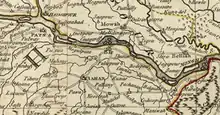
In 1776, James Rennell, also called the "Father of Indian Geography", surveyed Bengal and listed prominent destinations.[6]


Barh Railway line
On 10 November 1877, the Barh railway station was opened to the public.[7]
Plague
Between the 1890s to 1910, Barh and Patna were afflicted by the plague. It is believed that the 1898 plague came by sea by rats aboard infected ships, though it first appeared in the British India Steam Navigation Company's wharf.[8] The two main factors for the spread of the plague were believed to be the high presence of rats and houses with poor hygiene and bad ventilation.[8]
The population of the extended Barh subdivision decreased from 408,256 in 1891 to 365,327 in 1901 due to the plague.[9]
Sati incident
In 1928, Sampati Kuer, a young widow from Berhna village, committed sati on the funeral pyre of her deceased husband. The British government suspected foul play and sentenced 10 people to prison, including her brother Murlidhar Pande, as sati was outlawed 100 years earlier by the British government.[10]
NTPC Barh
NTPC Limited is India's largest power-generating company. The former Prime Minister of India, Atal Bihari Vajpayee, laid the foundation stone of the main plant of stage 1 of NTPC Barh Super Thermal Power Station on 6 March 1999.[11]
List of villages
The list of villages in Barh Block (under Barh Tehsil) is as follows:
- Sadikpur
- saksohra
- Agwanpur
- Ranabigha
- Berhana East
- Berhana West
- Bhatgawn
- Dhanwan Mobarakpur
- Ekdanga
- Ibrahimpur
- Nadawan
- Naruada
- Rahimpur Rupas
- Rangbigha
- Sarkatti Saidpur
- Shohari
- Achuara
- DAHAUR
References
- "Hindu Funerals, Cremation and Varanasi". 16 October 2013. Archived from the original on 16 October 2013. Retrieved 30 July 2020.
- Census of India. Office of the Registrar General. OCLC 181774275.
- Sharma, Navendu (31 October 2010). "No Barh on caste politics". The Times of India. Retrieved 25 July 2020.
- Stewart, Charles (1813). The History of Bengal: From the First Mohammedan Invasion Until the Virtual Conquest of that Country by the English, A.D. 1757. Black, Parry, and Company.
bar.
- http://shodhganga.inflibnet.ac.in/bitstream/10603/18028/7/07_chapter%201.pdf
- "A map of the north part of Hindostan or a geographical survey of the provinces of Bengal, Bahar, Awd, Ellahabad, Agra and Delhi · Online Exhibits". www.lib.umich.edu.
- "Report on the Administration of Bengal, 1877–78". 1878.
- Clemesha, W. W. "An Account of Plague in Bengal".
- O'Malley, L. S. S. (1924). Bihar and Orissa District Gazetteers Patna. ISBN 9788172681210.
- "Archived copy" (PDF). Archived from the original (PDF) on 7 May 2018. Retrieved 7 May 2018.
{{cite web}}: CS1 maint: archived copy as title (link) - Chaudhary, Pranava K. (4 July 2013). "Barh thermal power plant to start power generation by year end". The Times of India. Retrieved 27 July 2020.