Bargo River
The Bargo River, a watercourse of the Hawkesbury-Nepean catchment, is located in the Southern Highlands and Macarthur districts of New South Wales, Australia.
| Bargo | |
|---|---|
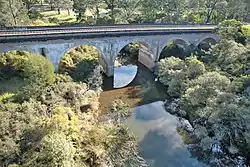 Railbridge over Bargo River, Tahmoor, NSW Australia | |
| Etymology | Aboriginal: Barago, meaning cripple, thick scrub, or brushwood[1] |
| Location | |
| Country | Australia |
| State | New South Wales |
| Region | Sydney Basin (IBRA), Southern Highlands, Macarthur |
| Local government areas | Wingecarribee, Wollondilly |
| Physical characteristics | |
| Source | Colo Vale |
| • location | northwest of Alpine |
| Mouth | confluence with the Nepean River |
• location | near Bargo |
| Length | 27 km (17 mi) |
| Basin features | |
| River system | Hawkesbury-Nepean catchment |
| Tributaries | |
| • left | Ropesand Creek |
| [2] | |
Course
The Bargo River rises in the southern slopes of Southern Highlands, north of Colo Vale, and flows generally north-east, joined by two minor tributaries, before reaching its confluence with the Nepean River, near Bargo.
In its upper catchment, the river runs through Bargo River State Conservation Area, a nature reserve located between Hill Top and Yerrinbool.[3]
See also
References
- Reed, A. W (1973). Australian Place Names. Artarmon: Reed. ISBN 0-589-07115-7.
- "Place Name Search: Bargo River". Geoscience Australia. Commonwealth of Australia. 2010. Archived from the original on 24 December 2013. Retrieved 26 February 2013.
- "Bargo River State Conservation Area". NSW National Parks & Wildlife Service. Government of New South Wales. Retrieved 26 February 2013.
This article is issued from Wikipedia. The text is licensed under Creative Commons - Attribution - Sharealike. Additional terms may apply for the media files.