Bannister, New South Wales
Bannister is a locality in the Upper Lachlan Shire, New South Wales, Australia.[2][3] It lies about 20 km south of Crookwell and 90 km northeast of Canberra. At the 2016 census, it had a population of 120.[4]
| Bannister New South Wales | |||||||||||||||
|---|---|---|---|---|---|---|---|---|---|---|---|---|---|---|---|
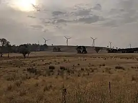 Crookwell 2 Wind Farm from Bannister in 2019 | |||||||||||||||
 Bannister Location in New South Wales | |||||||||||||||
| Coordinates | 34°35′54″S 149°29′34″E | ||||||||||||||
| Population | 141 (SAL 2021)[1] | ||||||||||||||
| Postcode(s) | 2580 | ||||||||||||||
| Elevation | 897 m (2,943 ft) | ||||||||||||||
| Location | |||||||||||||||
| LGA(s) | Upper Lachlan Shire | ||||||||||||||
| Region | Southern Tablelands | ||||||||||||||
| County | Argyle | ||||||||||||||
| Parish | Pomeroy | ||||||||||||||
| State electorate(s) | Goulburn | ||||||||||||||
| Federal division(s) | Hume | ||||||||||||||
| |||||||||||||||
Bannister was named after Saxe Bannister, first Attorney General of New South Wales.[2] It had a state school from 1878 to 1968. This was described at different times as a "public school", a "half-time school" or a "provisional school". Prior to May 1915, it was called Gullen Flat Public School.[5]
References
- Australian Bureau of Statistics (28 June 2022). "Bannister (NSW) (Suburb and Locality)". Australian Census 2021 QuickStats. Retrieved 28 June 2022.
- "Bannister". Geographical Names Board. Retrieved 7 March 2020.
- "Bannister". OpenStreetMap. Retrieved 7 March 2020.
- Australian Bureau of Statistics (27 June 2017). "Bannister". 2016 Census QuickStats. Retrieved 7 March 2020.
- "Bannister in the School history database search". New South Wales Department of Education. Retrieved 7 March 2020.
| Towns | |
|---|---|
| Localities and rural places |
|
Main Article: Local government areas of New South Wales | |
This article is issued from Wikipedia. The text is licensed under Creative Commons - Attribution - Sharealike. Additional terms may apply for the media files.