Azarshahr County
Azarshahr County (Persian: شهرستان آذرشهر) is in East Azerbaijan province, Iran. Its capital is the city of Azarshahr.
Azarshahr County
Persian: شهرستان آذرشهر | |
|---|---|
County | |
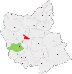 Location of Azarshahr County in East Azerbaijan province | |
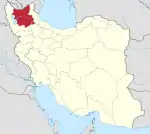
 Location of East Azerbaijan province in Iran | |
| Coordinates: 37°43′N 45°48′E[1] | |
| Country | Iran |
| Province | East Azerbaijan |
| Capital | Azarshahr |
| Districts | Howmeh, Gugan, Mamqan |
| Population (2016) | |
| • Total | 110,311 |
| Time zone | UTC+3:30 (IRST) |
| Azarshahr County can be found at GEOnet Names Server, at this link, by opening the Advanced Search box, entering "9205841" in the "Unique Feature Id" form, and clicking on "Search Database". | |
At the 2006 census, the county's population was 99,286 in 26,857 households.[2] The following census in 2011 counted 107,579 people in 31,812 households.[3] At the 2016 census, the county's population was 110,311 in 35,364 households.[4]
Administrative divisions
The population history and structural changes of Azarshahr County's administrative divisions over three consecutive censuses are shown in the following table. The latest census shows two districts, seven rural districts, and four cities.[4]
| Administrative Divisions | 2006[2] | 2011[3] | 2016[4] |
|---|---|---|---|
| Howmeh District | 64,796 | 69,260 | 73,544 |
| Qazi Jahan Rural District | 5,853 | 6,183 | 6,083 |
| Qebleh Daghi Rural District | 8,342 | 8,659 | 8,239 |
| Shiramin Rural District | 7,862 | 7,933 | 7,550 |
| Yengejeh Rural District | 6,264 | 6,567 | 6,785 |
| Azarshahr (city) | 36,475 | 39,918 | 44,887 |
| Gugan District | 23,616 | 24,954 | 24,873 |
| Dastjerd Rural District | 4,944 | 5,561 | 5,083 |
| Teymurlu Rural District | 7,723 | 7,998 | 2,673 |
| Gugan (city) | 10,949 | 11,395 | 11,742 |
| Teymurlu (city) | 5,375 | ||
| Mamqan District | 10,874 | 13,365 | 11,892 |
| Shahrak Rural District | —1 | —1 | 0 |
| Mamqan (city) | 10,872 | 13,359 | 11,892 |
| Total | 99,286 | 107,579 | 110,311 |
| 1Population below reporting threshold in 2006 and 2011 censuses | |||
Wikimedia Commons has media related to Azarshahr County.
References
- OpenStreetMap contributors (3 April 2023). "Azarshahr County" (Map). OpenStreetMap. Retrieved 3 April 2023.
- "Census of the Islamic Republic of Iran, 1385 (2006)". AMAR (in Persian). The Statistical Center of Iran. p. 03. Archived from the original (Excel) on 20 September 2011. Retrieved 25 September 2022.
- "Census of the Islamic Republic of Iran, 1390 (2011)" (Excel). Iran Data Portal (in Persian). The Statistical Center of Iran. p. 03. Retrieved 19 December 2022.
- "Census of the Islamic Republic of Iran, 1395 (2016)". AMAR (in Persian). The Statistical Center of Iran. p. 03. Archived from the original (Excel) on 13 November 2020. Retrieved 19 December 2022.
| Capital | |||||||||||||||||||||||||||||||||
|---|---|---|---|---|---|---|---|---|---|---|---|---|---|---|---|---|---|---|---|---|---|---|---|---|---|---|---|---|---|---|---|---|---|
| Districts |
| ||||||||||||||||||||||||||||||||
This article is issued from Wikipedia. The text is licensed under Creative Commons - Attribution - Sharealike. Additional terms may apply for the media files.