Aurora Springs, Missouri
Aurora Springs is an unincorporated community and census-designated place in northern Miller County, in the U.S. state of Missouri.[3] The community is located on Saline Creek, just south of Eldon and west of U.S. Route 54.[4]
Aurora Springs, Missouri | |
|---|---|
| Coordinates: 38°19′28″N 92°34′56″W | |
| Country | United States |
| State | Missouri |
| County | Miller |
| Area | |
| • Total | 0.43 sq mi (1.11 km2) |
| • Land | 0.43 sq mi (1.11 km2) |
| • Water | 0.00 sq mi (0.00 km2) |
| Elevation | 909 ft (277 m) |
| Population (2020) | |
| • Total | 138 |
| • Density | 320.93/sq mi (123.95/km2) |
| FIPS code | 29-02584 |
| GNIS feature ID | 2804674[2] |
History
Aurora Springs was platted in 1880, and named for a mineral spring near the original town site.[5] A post office called Aurora Springs was established in 1882, and remained in operation until 1912.[6]
References
- "ArcGIS REST Services Directory". United States Census Bureau. Retrieved September 5, 2022.
- U.S. Geological Survey Geographic Names Information System: Aurora Springs, Missouri
- U.S. Geological Survey Geographic Names Information System: Aurora Springs, Missouri
- Eldon, Missouri, 7.5 Minute Topographic Quadrangle, USGS, 1983
- "Miller County Place Names, 1928–1945". The State Historical Society of Missouri. Archived from the original on June 24, 2016. Retrieved November 6, 2016.
- "Post Offices". Jim Forte Postal History. Retrieved November 6, 2016.
- "Census of Population and Housing". Census.gov. Retrieved June 4, 2016.
Municipalities and communities of Miller County, Missouri, United States | ||
|---|---|---|
| Cities | 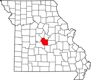 Map of Missouri highlighting Miller County | |
| Villages | ||
| Townships | ||
| CDP | ||
| Other communities | ||
| Footnotes | ‡This populated place also has portions in an adjacent county or counties | |
This article is issued from Wikipedia. The text is licensed under Creative Commons - Attribution - Sharealike. Additional terms may apply for the media files.