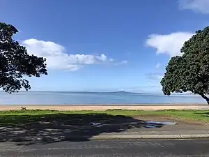
Arkles Bay
Arkles Bay is one of the northernmost suburbs of the contiguous Auckland metropolitan area located in New Zealand. It is located on the southern side of the Whangaparaoa Peninsula, in the Hibiscus Coast, located 25 kilometres (16 mi) north of the Auckland CBD.[3] It is part of the Albany Ward area for local government purposes.[4] Arkles Bay is known for its sheltered beaches, suitable for swimming and paddle boarding.[5]
Arkles Bay | |
|---|---|
 | |
| Coordinates: 36.64252994°S 174.75061100°E | |
| Country | New Zealand |
| City | Auckland |
| Local authority | Auckland Council |
| Electoral ward | Albany ward |
| Local board | Hibiscus and Bays Local Board |
| Area | |
| • Land | 18 ha (44 acres) |
| Population (2018)[2] | |
| • Total | 252 |
| Postcode(s) | 0932 |
| Stanmore Bay | Whangaparaoa | Manly |
| Weiti River |
|
|
| (Hauraki Gulf / Tīkapa Moana) |
Demographics
Arkles Bay covers 0.18 km2 (0.069 sq mi).[1] It is part of the larger Whangaparāoa Central statistical area.[6]
| Year | Pop. | ±% p.a. |
|---|---|---|
| 2006 | 225 | — |
| 2013 | 243 | +1.11% |
| 2018 | 252 | +0.73% |
| Source: [2] | ||
Arkles Bay had a population of 252 at the 2018 New Zealand census, an increase of 9 people (3.7%) since the 2013 census, and an increase of 27 people (12.0%) since the 2006 census. There were 111 households, comprising 117 males and 132 females, giving a sex ratio of 0.89 males per female, with 39 people (15.5%) aged under 15 years, 36 (14.3%) aged 15 to 29, 120 (47.6%) aged 30 to 64, and 57 (22.6%) aged 65 or older.
Ethnicities were 91.7% European/Pākehā, 8.3% Māori, 3.6% Pacific peoples, and 6.0% Asian. People may identify with more than one ethnicity.
Although some people chose not to answer the census's question about religious affiliation, 51.2% had no religion, 36.9% were Christian, 1.2% were Hindu and 2.4% were Buddhist.
Of those at least 15 years old, 45 (21.1%) people had a bachelor's or higher degree, and 36 (16.9%) people had no formal qualifications. 51 people (23.9%) earned over $70,000 compared to 17.2% nationally. The employment status of those at least 15 was that 96 (45.1%) people were employed full-time, 42 (19.7%) were part-time, and 6 (2.8%) were unemployed.[2]
References
- "ArcGIS Web Application". statsnz.maps.arcgis.com. Retrieved 4 June 2022.
- "Statistical area 1 dataset for 2018 Census". Statistics New Zealand. March 2020. 7001654 and 7001657.
- "New Zealand Topographic Map". NZ Topo Map. Retrieved 26 November 2021.
- Council, Auckland. "Albany ward map" (PDF). aucklandcouncil.govt.nz. Archived (PDF) from the original on 11 February 2018.
- "Arkles Bay". Anita Dobson & Kieran Barakat. 7 April 2020. Retrieved 26 November 2021.
- 2018 Census place summary: Whangaparāoa Central