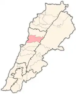
Aramoun, Keserwan
Aramoun (Arabic: عرمون; also spelled Aaramoun or ′Aramun) is a town and municipality located in the Keserwan District of the Keserwan-Jbeil Governorate of Lebanon. The town is about 28 kilometres (17 mi) north of Beirut.[1] It has an average elevation of 730 meters above sea level and a total land area of 148 hectares.[1] Aramoun's inhabitants are Maronites.[2]
Aramoun
عرمون | |
|---|---|
Municipality | |
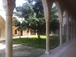 The Monastery of Saint Nicolas in Aramoun, formerly the house of al-Dahdah | |
 Aramoun Location in Lebanon | |
| Coordinates: 34°1′9″N 35°42′1″E | |
| Country | |
| Governorate | Keserwan-Jbeil |
| District | Keserwan |
| Area | |
| • Total | 1.48 km2 (0.57 sq mi) |
| Elevation | 730 m (2,400 ft) |
| Time zone | UTC+2 (EET) |
| • Summer (DST) | UTC+3 (EEST) |
History
In 1838, Eli Smith noted Aramun as a village located in "Aklim el-Kesrawan, Northeast of Beirut; the chief seat of the Maronites".[3]
In 1959, an Ariana Airlines plane crashed just moments after taking off from the nearby Beirut International airport. The flight, Flight 202 was going to Iran and then to Afghanistan.
References
- "Aaramoun (Kesrwan)". Localiban. Localiban. 2008-01-19. Retrieved 2016-02-26.
- "Elections municipales et ikhtiariah au Mont-Liban" (PDF). Localiban. Localiban. 2010. p. 19. Archived from the original (pdf) on 2015-07-24. Retrieved 2016-02-26.
- Robinson and Smith, 1841, vol 3, 2nd appendix, p. 194
Bibliography
Capital: Jounieh | ||
| Towns and villages |
|  |
| Notable landmarks | ||
This article is issued from Wikipedia. The text is licensed under Creative Commons - Attribution - Sharealike. Additional terms may apply for the media files.