Aradan County
Aradan County (Persian: شهرستان آرادان) is in Semnan province, Iran. Its capital is the city of Aradan.[3]
Aradan County
Persian: شهرستان آرادان | |
|---|---|
County | |
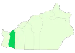 Location of Aradan County in Semnan province | |
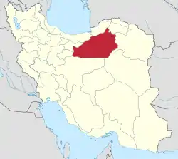 Location of Semnan province in Iran | |
| Coordinates: 34°55′43″N 52°36′50″E[1] | |
| Country | Iran |
| Province | Semnan |
| Capital | Aradan |
| Districts | Central, Kohanabad |
| Population (2016)[2] | |
| • Total | 13,884 |
| Time zone | UTC+3:30 (IRST) |
| Aradan County can be found at GEOnet Names Server, at this link, by opening the Advanced Search box, entering "9206417" in the "Unique Feature Id" form, and clicking on "Search Database". | |
At the 2006 census, the region's population (as Aradan District of Garmsar County) was 15,418 in 4,437 households.[4] The following census in 2011 counted 15,575 people in 4,882 households.[5] It was separated from Garmsar County in 2011 to form Aradan County.[3] At the 2016 census, the county's population was 13,884 in 4,919 households.[2]
Administrative divisions
The population history and structural changes of Aradan County's administrative divisions over three consecutive censuses are shown in the following table. The latest census shows two districts, four rural districts, and two cities.[2]
| Administrative Divisions | 2006[4] | 2011[5] | 2016[2] |
|---|---|---|---|
| Central District | 10,673 | 11,807 | 11,060 |
| Hoseynabad-e Kordehha Rural District | 2,275 | ||
| Yateri Rural District | 5,714 | 6,181 | 2,528 |
| Aradan (city) | 4,959 | 5,626 | 6,257 |
| Kohanabad District | 4,745 | 3,768 | 2,824 |
| Faravan Rural District | 1,134 | ||
| Kohanabad Rural District | 4,745 | 3,768 | 498 |
| Kohanabad (city) | 1,192 | ||
| Total | 15,418 | 15,575 | 13,884 |
| 1As a part of Garmsar County at the 2006 and 2011 censuses | |||
Wikimedia Commons has media related to Aradan County.
References
- OpenStreetMap contributors (23 April 2023). "Aradan County" (Map). OpenStreetMap. Retrieved 23 April 2023.
- "Census of the Islamic Republic of Iran, 1395 (2016)". AMAR (in Persian). The Statistical Center of Iran. p. 20. Archived from the original (Excel) on 17 November 2020. Retrieved 19 December 2022.
- Rahimi, Mohammadreza (10 October 1392). "Aradan County was added to the map of country divisions". DOLAT (in Persian). Ministry of Interior, Board of Ministers. Archived from the original on 2 October 2013. Retrieved 23 April 2023.
- "Census of the Islamic Republic of Iran, 1385 (2006)". AMAR (in Persian). The Statistical Center of Iran. p. 20. Archived from the original (Excel) on 20 September 2011. Retrieved 25 September 2022.
- "Census of the Islamic Republic of Iran, 1390 (2011)" (Excel). Iran Data Portal (in Persian). The Statistical Center of Iran. p. 20. Retrieved 19 December 2022.
| Capital |  | ||||||||||||||||
|---|---|---|---|---|---|---|---|---|---|---|---|---|---|---|---|---|---|
| Counties and cities |
| ||||||||||||||||
| Sights |
| ||||||||||||||||
| populated places | |||||||||||||||||
| Capital | |||||||||||||||||||||
|---|---|---|---|---|---|---|---|---|---|---|---|---|---|---|---|---|---|---|---|---|---|
| Districts |
| ||||||||||||||||||||
This article is issued from Wikipedia. The text is licensed under Creative Commons - Attribution - Sharealike. Additional terms may apply for the media files.