Alberta Highway 38
Alberta Provincial Highway No. 38, commonly referred to as Highway 38, is a 25 km (16 mi) east–west highway in central Alberta, Canada. It extends from Highway 28 in Redwater to a 'T' junction with Highway 45 north of Bruderheim.[2][1]
Highway 38 | ||||
|---|---|---|---|---|
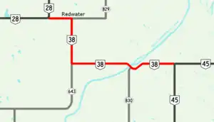 Highway 38 highlighted in red | ||||
| Route information | ||||
| Maintained by Alberta Ministry of Transportation | ||||
| Length | 25.9 km[1] (16.1 mi) | |||
| Major junctions | ||||
| West end | ||||
| East end | ||||
| Location | ||||
| Country | Canada | |||
| Province | Alberta | |||
| Specialized and rural municipalities | Sturgeon County, Strathcona County, Lamont County | |||
| Towns | Redwater | |||
| Highway system | ||||
|
| ||||
| ||||

Major intersections
From west to east:
| Rural/specialized municipality | Location | km[1] | mi | Destinations | Notes |
|---|---|---|---|---|---|
| Sturgeon County | Redwater | 0.0 | 0.0 | ||
| 4.3 | 2.7 | Hwy 38 branches south | |||
| | 10.8 | 6.7 | Hwy 38 branches east | ||
| ↑ / ↓ | | 19.1 | 11.9 | Vinca Bridge across North Saskatchewan River | |
| Strathcona County | | 19.4 | 12.1 | ||
| Lamont County | | 25.9 | 16.1 | Through traffic follows Hwy 45 east | |
| 1.000 mi = 1.609 km; 1.000 km = 0.621 mi | |||||
References
- Google (March 5, 2018). "Highway 38 in Alberta" (Map). Google Maps. Google. Retrieved March 5, 2018.
- "2015 Provincial Highway 1-216 Progress Chart" (PDF). Alberta Transportation. March 2015. Archived (PDF) from the original on April 10, 2016. Retrieved October 12, 2016.
This article is issued from Wikipedia. The text is licensed under Creative Commons - Attribution - Sharealike. Additional terms may apply for the media files.