Abulog
The Abulog River or Abulug River is the 9th largest river system in the Philippines in terms of watershed size.[1][2] It has an estimated drainage area of 3,372 square kilometres (1,302 sq mi) and a length of 196 kilometres (122 mi) from its source in the mountains of Apayao in the Cordillera Administrative Region. More than 90% of the drainage area of the river is located in Apayao province while the remaining, including the mouth of the river, is in Cagayan province.
| Abulog River | |
|---|---|
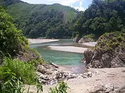 | |
.svg.png.webp) Abulog River mouth .svg.png.webp) Abulog (Philippines) | |
| Location | |
| Country | |
| Region | |
| Province | |
| Physical characteristics | |
| Source | |
| • location | Apayao |
| Mouth | |
• elevation | 0 m (0 ft) |
| Length | 196 km (122 mi) |
| Basin size | 3,372 km2 (1,302 sq mi) |
| Depth | |
| • minimum | 200 m3/s (7,100 cu ft/s) |
| Discharge | |
| • location | Babuyan Channel |
The upper reaches of the Abulug River, especially upstream from Kabugao, is commonly known as the Apayao River.
References
- "Dams in the Cordillera" (PDF). Cordillera People's Alliance, Public Information Commission. 2001. Archived from the original (PDF) on 28 August 2008. Retrieved 2008-09-19.
- "Principal River Basins of the Philippines" Published by the National Water Resources Board, October 1976 (p 12)
This article is issued from Wikipedia. The text is licensed under Creative Commons - Attribution - Sharealike. Additional terms may apply for the media files.