Aberffraw
Aberffraw[1][2] is a village and community on the south west coast of the Isle of Anglesey (Welsh: Ynys Môn), in Wales, by the west bank of the Afon Ffraw (Ffraw River). The community includes Soar and Dothan. Located near the A4080 and the nearest rail station is Bodorgan.
| Aberffraw | |
|---|---|
 | |
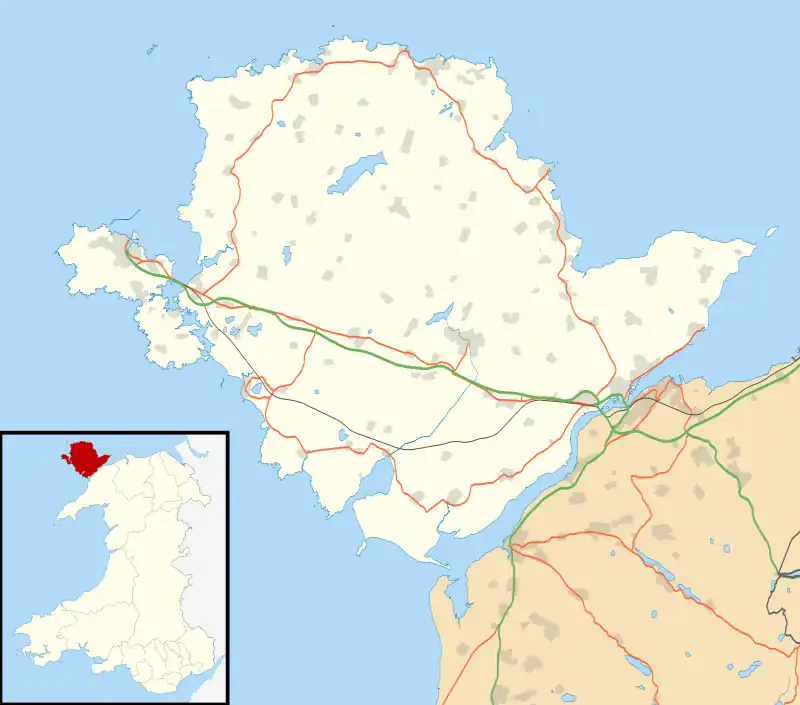 Aberffraw Location within Anglesey | |
| Population | 620 (2011) |
| OS grid reference | SH3568 |
| Community |
|
| Principal area | |
| Preserved county | |
| Country | Wales |
| Sovereign state | United Kingdom |
| Post town | TŶ CROES |
| Postcode district | LL63 |
| Dialling code | 01407 |
| Police | North Wales |
| Fire | North Wales |
| Ambulance | Welsh |
| UK Parliament | |
| Senedd Cymru – Welsh Parliament | |
History
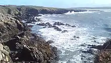
Aberffraw is one of the oldest Mesolithic sites from prehistoric Wales, dating c. 9,000 years ago. At Aberffraw bay is the Trwyn Du (Welsh: Black nose) excavated site. The site was discovered whilst excavating a Bronze Age kerb cairn (bowl barrow) from 2,000 BC. The kerb cairn was excavated because of the threat of coastal erosion in the bay. The archaeological excavation in 1977 revealed a prehistoric site. The carin was built on top of a deposit of 7,000 thousand flint tools and 2 axes from after the last Ice Age.[3][4][5]
Medieval Royal House of Aberffraw
In the early Middle Ages, Aberffraw was the capital of the Kingdom of Gwynedd from c.860 AD until c.1170. Under the House of Aberffraw it came to be the most important political centre in medieval Wales. The Llys remained the symbolic throne of the Kings of Gwynedd from the 9th century to the 13th century. The Royal Annals of Edward I of England show the Llys was dismantled in 1315 to provide building materials for nearby Beaumaris Castle.
The probable site of a medieval llys, a princely court partly dismantled in 1317. Excavation, 1973-4 (White 1979) & 1979, with further work 1987-8 (White & Longley 1995), recorded part of a rectilinear enclosure with at least one rounded corner. Its ditch had been recut on at least one occasion. It was traced for 70m north-north-east to south-south-west. Initially [sic] thought to represent a Roman military work, refurnished in the early medieval period. The apparently curving corner has suggested the presence of a castle mound ... This overall interpretation is supported by a radio-carbon determination of about 27-387AD ... counts against the presence of a fort. It is possible that this was the site of a later Prehistoric style settlement occupied in the Roman period.[6]
Aberffraw cantref (hundred)
The Meyrick (Welsh: Meurig) family of Bodorgan, Anglesey, were given the Crown lease for the manor lands of the Aberffraw cantref during the Tudor period (c. 1500). Llewelyn Ap Heilyn fought at the Battle of Bosworth alongside Henry VII of England. Afterward, Heilyn's son Meurig ap Llewelyn became captain of the bodyguard to Henry VIII and was rewarded with the lease. Today, the same family at Bodorgan Hall (near Aberffraw) is represented by the Tapps-Gervis-Meyrick baronets.[7][8] After the Meyrick family ownership, it was the Owen family of Penrhos locally on Anglesey who owned the lands of Aberffraw until 1808. Then subsequently, the Hughes family of Baron Dinorben, the Williams and Wynn families of Baron Newborough, then the Marquess of Anglesey Paget family, and finally Lord Bulkeley (Viscount) all briefly owned the lands surrounding Aberffraw. Today the current town was developed in the mid to late 20th century.[9]
Aberffraw village
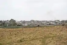
At the 2011 census, Aberffraw had a population of 620,[10] of which 67.5% speak Welsh.[11][12] The name of the village is often truncated to "Berffro" in the local Welsh dialect.[13]
Attractions near Aberffraw village include Llyn Coron, Barclodiad y Gawres, a neolithic burial chamber and the tidal island of Cribinau with church of Saint Cwyfan perched on top. The church still holds services in the summer and is sometimes used for weddings. The village has a sandy beach, which was awarded the Blue flag rural beach award in 2005, and is on the Anglesey Coastal Path. There is a post office in the village. St Beuno's Church, Aberffraw, dates from the 12th century and is a Grade II* listed building.[14] The village also has an association football team. The village school, Ysgol Aberffraw, closed in 2011.[15]
Governance
Until the 2012 Isle of Anglesey electoral boundary changes an electoral ward in the same name existed. This ward also included part of the community of Llanfaelog. The total population was 1,370.[16] Since the boundary changes Aberffraw has been part of a larger Bro Aberffraw ward which elects two county councillors to the Isle of Anglesey County Council.[17] As of the 2022 election, the ward is represented by Plaid Cymru councillors Arfon Wyn and John Ifan Jones.[18]
Demographics
Aberffraw's population was 620, according to the 2011 census;[19] a 1.97% increase since the 608 people noted in 2001.[20]
The 2011 census showed 67.5% of the population could speak Welsh, a fall from 80.8% in 2001.[11]
In mythology
In Welsh mythology, Aberffraw features as the site of Branwen and Matholwch's wedding festival, where Efnysien maimed Matholwch's horses.[21]
Notes
- "Search: Aberffraw". Enwau Cymru. University of Wales. Retrieved 16 April 2013.
- Spelled variously in period sources, including Aberfrau.
- "Trwyn du Scheduled Monuments- Full Report". cadwpublilc-api.azurewebsites.net. Retrieved 29 August 2023.
- "Trwyn Du Cairn near Aberffraw, Overlying A Mesolithic Site (302323)". Coflein. RCAHMW.
- "Aberffraw to port Cwyfan, Anglesey" (PDF). walescostalpath.gov.uk.
- "Aberffraw, Excavated Features, Rejected Roman Fort And Suggested Llys Site (401126)". Coflein. RCAHMW.
- "Meyrick family, Bodorgan, Anglesey.". Dictionary of Welsh Biography. National Library of Wales.
- Kidd, Charles, ed. (1903). Debrett's peerage, baronetage, knightage, and companionage. London: Dean & Son. p. 414.
- "Aberffraw (32986)". Coflein. RCAHMW. Retrieved 15 September 2023.
- "Parish Headcounts: Isle of Anglesey". Neighbourhood Statistics. Office for National Statistics. Archived from the original on 26 May 2013. Retrieved 16 April 2013.
- "2011 Census results by Community". Welsh Language Commissioner. 26 October 2012. Archived from the original on 14 September 2017. Retrieved 25 June 2017.
- "2011 Census results by Community". Welsh Language Commissioner. 26 October 2012. Archived from the original on 14 September 2017. Retrieved 25 June 2017.
- Rhys, Guto (2022). Amrywiaith 2 - Blas ar dafodieithoedd Cymru (in Welsh) (1 ed.). Llanrwst: Carreg Gwalch. p. 40. ISBN 9781845278526.
- Cadw. "Church of St. Beuno (5270)". National Historic Assets of Wales. Retrieved 11 April 2019.
- Jones, Geraint (15 July 2011). "Final bell looming for Ysgol Aberffraw". North Wales Chronicle. NWN Media Ltd. Retrieved 25 June 2017.
- "Ward population 2011". Retrieved 18 May 2015.
- "Isle of Anglesey (Electoral Arrangements) Order 2012" (PDF). legislation.gov.uk. The National Archives. Retrieved 9 December 2017.
- "Election results for Bro Aberffraw, 5 May 2022". democracy.anglesey.gov.uk. 5 May 2022. Retrieved 2 June 2023.
- "Area: Aberffraw (Parish)". Office for National Statistics. 30 January 2013. Retrieved 12 August 2015.
- "Area: Aberffraw (Parish)". Office for National Statistics. 18 November 2004. Retrieved 12 August 2015.
- The Mabinogion: Branwen the Daughter of Llyr, translated by Lady Charlotte Guest. Online at www.sacred-texts.com.
Further reading
- Davies, John. A History of Wales.
External links
- A Vision of Britain Through Time
- British Listed Buildings
- Aberffraw: historical and genealogical information at GENUKI.
- Geograph
- Office for National Statistics
- Ysgol Aberffraw

Native Welsh castles and llysoedd in North Wales | ||
|---|---|---|
| Built by Llywelyn ab Iorwerth | .jpg.webp) | |
| Other stone castles |
| |
| Earthwork castles |
| |
| Royal llysoedd | ||