Abanda, Alabama
Abanda is a census-designated place and unincorporated community in Chambers County, Alabama, United States. Its population was 133 as of the 2020 census.
Abanda, Alabama | |
|---|---|
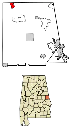 Location of Abanda in Chambers County, Alabama. | |
 Abanda  Abanda | |
| Coordinates: 33°06′03″N 85°31′47″W | |
| Country | United States |
| State | Alabama |
| County | Chambers |
| Area | |
| • Total | 3.01 sq mi (7.80 km2) |
| • Land | 3.00 sq mi (7.76 km2) |
| • Water | 0.01 sq mi (0.03 km2) |
| Elevation | 646 ft (197 m) |
| Population (2020) | |
| • Total | 133 |
| • Density | 44.36/sq mi (17.13/km2) |
| Time zone | UTC-6 (Central (CST)) |
| • Summer (DST) | UTC-5 (CDT) |
| ZIP code | 36276 |
| Area code | 334 |
| GNIS feature ID | 112879[2] |
History
Abanda was founded when the Atlanta, Birmingham and Atlantic Railroad (ABandA) was extended to that point.[3] A post office was established at Abanda in 1908, and remained in operation until it was discontinued in 1956.[4]
Demographics
| Census | Pop. | Note | %± |
|---|---|---|---|
| 2010 | 192 | — | |
| 2020 | 133 | −30.7% | |
| U.S. Decennial Census[5] | |||
Abanda first appeared on the 2010 U.S. Census as a census-designated place (CDP).[6]
2020 census
| Race / Ethnicity | Pop 2010[7] | Pop 2020[8] | % 2010 | 2020 |
|---|---|---|---|---|
| White alone (NH) | 129 | 95 | 67.19% | 71.43% |
| Black or African American alone (NH) | 58 | 34 | 30.21% | 25.56% |
| Native American or Alaska Native alone (NH) | 0 | 0 | 0.00% | 0.00% |
| Asian alone (NH) | 0 | 0 | 0.00% | 0.00% |
| Pacific Islander alone (NH) | 0 | 0 | 0.00% | 0.00% |
| Some Other Race alone (NH) | 0 | 0 | 0.00% | 0.00% |
| Mixed Race/Multi-Racial (NH) | 2 | 0 | 1.04% | 0.00% |
| Hispanic or Latino (any race) | 3 | 4 | 1.56% | 3.01% |
| Total | 192 | 133 | 100.00% | 100.00% |
Economy
The median household income in Abanda is $13,864 which is considerably smaller than the United States average median income of $53,046. Also, versus the state of Alabama, average median income of $43,160, Abanda is approximately a third that size.[9]
References
- "2020 U.S. Gazetteer Files". United States Census Bureau. Retrieved October 29, 2021.
- "Abanda". Geographic Names Information System. United States Geological Survey, United States Department of the Interior.
- Foscue, Virginia O. (1989). Place Names in Alabama. University of Alabama Press. p. 5. ISBN 978-0-8173-0410-2.
- "Chambers County". Jim Forte Postal History. Retrieved February 9, 2015.
- "Census of Population and Housing". Census.gov. Retrieved June 4, 2016.
- "Census data 2010" (PDF). census.gov. Retrieved April 15, 2023.
- "P2 HISPANIC OR LATINO, AND NOT HISPANIC OR LATINO BY RACE – 2010: DEC Redistricting Data (PL 94-171) – Abanda CDP, Alabama". United States Census Bureau.
- "P2 HISPANIC OR LATINO, AND NOT HISPANIC OR LATINO BY RACE - 2020: DEC Redistricting Data (PL 94-171) - Abanda CDP, Alabama". United States Census Bureau.
- "Abanda CDP Alabama Economy data and economic research". www.towncharts.com. Retrieved April 15, 2023.
Municipalities and communities of Chambers County, Alabama, United States | ||
|---|---|---|
| Cities | 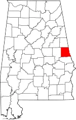 Map of Alabama highlighting Chambers County | |
| Towns | ||
| CDPs | ||
| Unincorporated communities | ||
| Ghost town | ||
| Footnotes | ‡This populated place also has portions in an adjacent county or counties | |
This article is issued from Wikipedia. The text is licensed under Creative Commons - Attribution - Sharealike. Additional terms may apply for the media files.