aMatikulu
aMatikulu is a settlement in Uthungulu District Municipality in the KwaZulu-Natal province of South Africa.
aMatikulu | |
|---|---|
 aMatikulu  aMatikulu | |
| Coordinates: 29.05°S 31.533333°E | |
| Country | South Africa |
| Province | KwaZulu-Natal |
| District | Uthungulu |
| Municipality | uMlalazi |
| Area | |
| • Total | 1.39 km2 (0.54 sq mi) |
| Population (2011)[1] | |
| • Total | 515 |
| • Density | 370/km2 (960/sq mi) |
| Racial makeup (2011) | |
| • Black African | 74.0% |
| • Coloured | 3.3% |
| • Indian/Asian | 16.9% |
| • White | 5.4% |
| • Other | 0.4% |
| First languages (2011) | |
| • Zulu | 59.8% |
| • English | 26.1% |
| • Afrikaans | 5.7% |
| • S. Ndebele | 4.7% |
| • Other | 3.7% |
| Time zone | UTC+2 (SAST) |
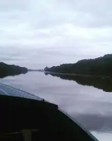
Boat ride at Amatigulu Nature Reserve
Town some 130 km north-east of Durban, near Gingindlovu. Named after the Matigulu, also spelt Amatikulu, River. From Lala or Zulu, probably "large water", i.e. "large river". The approved form is aMatikulu.[2]
References
- "Main Place aMatikulu". Census 2011.
- "Dictionary of Southern African Place Names (Public Domain)". Human Science Research Council. p. 299.
Municipalities and communities of King Cetshwayo District Municipality, KwaZulu-Natal | ||
|---|---|---|
District seat: Richards Bay | ||
| uMhlathuze | .svg.png.webp) King Cetshwayo District within South Africa | |
| uMlalazi | ||
| Nkandla | ||
| Mbonambi | ||
| Ntambanana | ||
| Mthonjaneni | ||
This article is issued from Wikipedia. The text is licensed under Creative Commons - Attribution - Sharealike. Additional terms may apply for the media files.