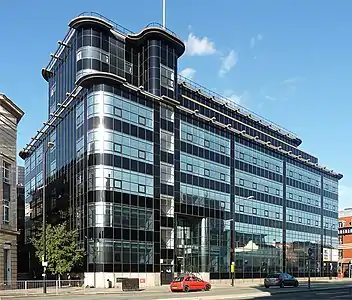
1 The Avenue
1 The Avenue is a building in Spinningfields, Manchester. It is situated on Deansgate adjacent to the grade-I listed John Rylands Library.
| 1 The Avenue | |
|---|---|
 | |
| Former names | 2 Spinningfields Square |
| General information | |
| Type | Office, Retail |
| Architectural style | Post modern |
| Location | Manchester |
| Country | United Kingdom |
| Construction started | 2007 |
| Opened | 2009 |
| Landlord | Allied London |
| Technical details | |
| Structural system | Steel |
| Floor area | 5,100m2 |
| Design and construction | |
| Architecture firm | Sheppard Robson |
| Structural engineer | Capita Symonds |
| References | |
| [1] | |
Architecture
The building consists of two mirror-image parallelograms, stacked one on top of the other, resulting in a three-storey 23 m (75 ft) cantilever on the east end of the building. The cantilever is supported by an inclined steel 'diagrid' structure.[2]
A diagrid is similar in shape to a triangle[3] and other building have used a diagrid structure, such as 30 St Mary Axe in London.[4]
Reaction to the glass clad building has been mixed due its proximity to the Grade I listed Rylands Library which, along with the Town Hall is considered the finest piece of architecture in Manchester and one of the finest interpretations of Gothic revival in the world.[5][6]
 1 The Avenue under construction
 Cantilever under construction
References
- "1 The Avenue". Spinningfields Manchester. Archived from the original on 10 March 2012. Retrieved 13 April 2012.
- "No 2 Spinningfields Square Manchester". steelconstruction.org. Archived from the original on 23 February 2013. Retrieved 13 April 2012.
- "The Design of High-rise Buildings Using Diagrid Structures". Arch2O. Retrieved 3 January 2022.
- Moussavi, Farshid (2012). "30 St. Mary Axe". Harvard Design Magazine. Harvard Graduate School of Design. Retrieved 3 January 2022.
- "By John Rylands Library I sat down and wept..." Manchester School of Architecture. 15 January 2009. Archived from the original on 19 March 2012. Retrieved 13 April 2012.
- Griffin, Phil (16 September 2008). "2 Spinningfields Square: an awkward fit or just right?". Manchester Confidential. Archived from the original on 15 September 2012. Retrieved 13 April 2012.
