1980 Grand Island tornado outbreak
The 1980 Grand Island tornado outbreak, also known as The Night of the Twisters, was a tornado outbreak that produced a series of destructive tornadoes that affected the city of Grand Island, Nebraska, on Tuesday, June 3, 1980. Seven tornadoes touched down in or near the city that night, killing five people and injuring 200.
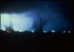
 Shown here is the second F3 to hit Grand Island (right) and the first F1 to hit the city (left). | |
| Duration | June 3, 1980 |
|---|---|
| Tornadoes confirmed | 29 |
| Max. rating1 | F4 tornado |
| Duration of tornado outbreak2 | 2 days |
| Fatalities | 6 fatalities, 413 injuries |
| Damage | $ 300 million (1980 USD) |
| Areas affected | Midwestern and Northeastern United States |
Part of the tornado outbreaks of 1980 1Most severe tornado damage; see Fujita scale 2Time from first tornado to last tornado | |
The name generally referred to by Grand Island area residents for the event, "The Night of the Twisters", comes from the semi-fictionalized book of the same name, loosely based on the June 3rd, 1980 tornadoes, by author Ivy Ruckman, which in turn inspired a made-for-TV movie of the same name that premiered on The Family Channel (now Freeform) in February 1996. While the outbreak is best known for the Grand Island tornado family on June 3, the event as a whole produced 29 tornadoes across two days, causing severe damage as far east as Pennsylvania.[1] In addition to the five deaths that occurred in the Grand Island area, the outbreak injured a total of 413 across seven states.
Outbreak description

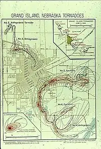
The outbreak began on June 2, producing strong tornadoes in Iowa, Indiana, and Ohio, including one that struck the east side of Indianapolis. One fatality occurred near Crawfordsville, Indiana. Tornado activity continued on June 3, with additional strong tornadoes touching down in Pennsylvania, Maryland, West Virginia, and Nebraska. Over a span of three hours on the evening of June 3, 1980, a slow-moving supercell complex moving across Grand Island, Nebraska, spawned several tornadoes. The resulting outbreak was one of the most unusual in United States history: The supercells moved over the city at only 8 mph (13 km/h); of the seven tornadoes, three of them were anticyclonic; and the tornadoes did not move in a straight line, with most looping back over their own path at least once.[1]
Confirmed tornadoes
| FU | F0 | F1 | F2 | F3 | F4 | F5 | Total |
|---|---|---|---|---|---|---|---|
| 0 | 2 | 11 | 9 | 4 | 3 | 0 | 29 |
June 2 event
| F# | Location | County / Parish | State | Start Coord. | Time (UTC) | Path length | Max width | Summary |
|---|---|---|---|---|---|---|---|---|
| F2 | SW of Belvidere | Thayer | NE | 40.23°N 97.6°W | 0930 | 2 mi (3.2 km) | 300 yd (270 m) | [2] |
| F2 | S of Allerton | Wayne | IA | 40.65°N 93.42°W | 1230 | 4.7 mi (7.6 km) | 80 yd (73 m) | Tornado struck a farm, twisting the house off its foundation and destroying several outbuildings. Six train cars were derailed and another home lost its roof.[1][2] |
| F1 | SW of Numa | Appanoose | IA | 40.67°N 93.02°W | 1300 | 2 mi (3.2 km) | 30 yd (27 m) | Three people were injured.[2] |
| F2 | Cincinnati to SE of West Grove | Appanoose, Davis | IA | 40.63°N 92.92°W | 1305 | 19.8 mi (31.9 km) | 80 yd (73 m) | Trees were damaged and three homes were partially unroofed. Three trailer homes were destroyed, and other homes and trailers were damaged. A Masonic Lodge was damaged as well. There were five injuries, all of which occurred in trailer homes.[1][2] |
| F2 | SSW of Covington | Fountain | IN | 40.13°N 87.4°W | 1800 | 0.1 mi (0.16 km) | 10 yd (9.1 m) | A hardware store and four homes were destroyed in Covington.[1][2] |
| F3 | SW of Waynetown to Ladoga | Montgomery | IN | 40.08°N 87.07°W | 1800 | 18.1 mi (29.1 km) | 10 yd (9.1 m) | 1 death – High-end F3 damage and serious injuries occurred southwest of Crawfordsville. One woman was killed when her trailer was obliterated and scattered over 30 acres. Caused $2,000,000 in damage and injured 16 people.[1][2] |
| F2 | Northern Indianapolis | Marion | IN | 39.78°N 86.15°W | 1900 | 0.1 mi (0.16 km) | 10 yd (9.1 m) | A high-end F2 tornado struck the east side of Indianapolis, destroying four homes and damaging a dozen others. Flying debris caused a traffic accident on I-465. Six people were injured.[1][2] |
| F2 | New Palestine | Hancock | IN | 39.72°N 85.88°W | 1930 | 0.1 mi (0.16 km) | 10 yd (9.1 m) | A high-end F2 tornado tore apart many homes in town and ripped the roof off of a grocery store. A high school and an elementary school were heavily damaged. Four people were injured, including a woman who was trapped in the debris of her trailer home.[1][2] |
| F0 | SW of Rushville | Rush | IN | 39.72°N 85.88°W | 2000 | 0.1 mi (0.16 km) | 10 yd (9.1 m) | One person was injured.[2] |
| F1 | Wyoming to S of Madeira | Hamilton | OH | 39.23°N 84.47°W | 2105 | 6.2 mi (10.0 km) | 70 yd (64 m) | There were 15 injuries.[2] |
| F4 | Lamoni to NW of Powersville, MO | Decatur, Wayne | IA | 40.62°N 93.92°W | 2125 | 31.2 mi (50.2 km) | 140 yd (130 m) | A long-track, violent tornado completely destroyed a farmhouse near Davis City, and unroofed a fertilizer plant.[1][2] |
| F1 | S of Epworth to S of Peosta | Dubuque | IA | 42.43°N 90.93°W | 2320 | 3.6 mi (5.8 km) | 50 yd (46 m) | [2] |
| F1 | Tippecanoe Lake | Kosciusko | IN | 41.32°N 85.75°W | 2330 | 0.1 mi (0.16 km) | 10 yd (9.1 m) | One person was injured.[2] |
| F1 | SW of Oak Hill to W of Patriot | Jackson, Lawrence, Gallia | OH | 39.23°N 84.47°W | 2330 | 11.5 mi (18.5 km) | 150 yd (140 m) | Two homes were unroofed and seven farm buildings were destroyed near the rural community of Blackford. Grazulis lists this tornado as an F2.[2][1] |
| F1 | SW of Dixon, IN and OH | Adams | IN | 40.92°N 84.83°W | 0000 | 0.1 mi (0.16 km) | 10 yd (9.1 m) | Three people were injured.[2] |
| F1 | E of Manchester | Washtenaw | MI | 42.15°N 84°W | 0535 | 0.1 mi (0.16 km) | 10 yd (9.1 m) | [2] |
June 3 event
| F# | Location | County / Parish | State | Start Coord. | Time (UTC) | Path length | Max width | Summary |
|---|---|---|---|---|---|---|---|---|
| F4 | NW of Harrison Township to Vandergrift to SE of Orchard Hills | Allegheny, Westmoreland, Armstrong | PA | 40.65°N 79.73°W | 1630 | 11.8 mi (19.0 km) | 10 yd (9.1 m) | A restaurant and two stores were severely damaged in Natrona Heights, with 12 injuries at that location. Seven homes were damaged in Vandergrift, and a trailer park in Apollo was devastated. One home was nearly leveled by this tornado. Caused $6,000,000 in damage and injured 140 people. Rated F3 by Grazulis.[1][3] |
| F2 | Avonmore to Clarksburg | Indiana | PA | 40.53°N 79.47°W | 1705 | 4.9 mi (7.9 km) | 10 yd (9.1 m) | A half dozen homes, a helicopter, and three trailers were torn apart. Six people were injured.[1][3] |
| F3 | SE of Ridgedale, West Virginia to Oakland, Maryland | Monongalia (WV), Preston (WV), Garrett (MD) | WV, MD | 39.53°N 79.9°W | 1705 | 29.8 mi (48.0 km) | 150 yd (140 m) | In West Virginia, 28 homes were destroyed and 102 others were damaged. Thirteen businesses and nine public buildings were damaged as well. Reedsville was hard hit. A mobile home park there was destroyed, and a two-year-old child was thrown nearly a mile into a field, but survived. The tornado continued into Maryland where two trailer homes were destroyed, 15 permanent homes were damaged, and 12 farms were damaged. Caused $7,000,000 in damage and 19 injuries. Most destructive West Virginia tornado since 1944.[1][3] |
| F1 | Vincentown | Burlington | NJ | 39.93°N 74.75°W | 2000 | 0.5 mi (0.80 km) | 30 yd (27 m) | [3] |
| F2 | N of Dover to N of Gilberts Corner | Loudoun | VA | 39°N 77.67°W | 2000 | 2.7 mi (4.3 km) | 100 yd (91 m) | [3] |
| F0 | N of Watford City | McKenzie | ND | 47.88°N 103.38°W | 2130 | 0.1 mi (0.16 km) | 10 yd (9.1 m) | [3] |
| F3 | SW of St. Libory to Western Grand Island | Hall | NE | 41.02°N 98.4°W | 0145–0234 | 6.4 mi (10.3 km) | 700 yd (640 m) | 1 death – Tornado touched down 11 miles northwest of Grand Island. First of seven tornadoes to hit the city in just over two hours. Farm homes outside of town were torn apart, and a woman was killed while trying to drive to a relative's house. 25 others were injured and caused an estimated $2.5 million in damages. Although the straight line (and official) path length of the tornado was only about 7.0 miles (11.3 km), the actual length was over double that at 14.5 miles (23.3 km) because the track was highly unusual in that it looped and crossed itself numerous times, while spending 49 minutes on the ground.[3][4] |
| F1 | Northwestern Grand Island | Hall | NE | 40.95°N 98.37°W | 0200–0212 | 0.8 mi (1.3 km) | 150 yd (140 m) | Small anticyclonic tornado briefly touched down in the northern edges of Grand Island, just east of the first tornado. Second of seven tornadoes to hit the city in just over two hours. The tornado caused an estimated $25,000 in damages and five injuries. First of three anticyclonic tornadoes.[3][4] |
| F3 | Grand Island | Hall | NE | 40.97°N 98.35°W | 0205–0230 | 2.3 mi (3.7 km) | 500 yd (460 m) | 1 death – Tornado touched down north of Grand Island and moved into the city near Airport Road, between US 281 and Webb Road. Third of seven tornadoes to hit the city in just over two hours. The tornado injured 40, killed one, and caused an estimated $2.5 million in damages. Although most damage was rated F0, several homes were heavily damaged and some F3 damage was noted near the veteran's home, which had windows blown out. Second of three anticyclonic tornadoes. While the path is officially listed as 2.3 miles (3.7 km), the distance covered by the tornado was 3.5 miles (5.6 km) due to its curving nature.[3][4] |
| F1 | Southeastern Grand Island | Hall | NE | 40.88°N 98.3°W | 0246–0250 | 2.3 mi (3.7 km) | 100 yd (91 m) | Fourth of seven tornadoes to hit the city in just over two hours. Tornado touched down southeast of Grand Island and moved toward the southwest, west, and north. This was the last of three anticyclonic tornadoes.[3][4] |
| F4 | Grand Island | Hall | NE | 40.92°N 98.3°W | 0316–0328 | 1.1 mi (1.8 km) | 1,700 yd (1,600 m) | 3 deaths – Fifth of seven tornadoes to hit the city in just over two hours. Tornado touched down just east of Grand Island, then moved west into the city. Once within the city, the tornado turned south and followed Locust Street, causing some of the most intense damage of the outbreak to businesses and neighboring residences, some of which were "obliterated". Numerous homes, vehicles, businesses, trees, and power lines were destroyed. Damages exceeded $200 million, and 110 people were injured. While the path length is listed as 1.1 miles (1.8 km), the curving path of the tornado covered a distance of 6 miles (9.7 km). Peak winds in the most intense damage areas were estimated to be at 250 miles per hour (400 km/h).[3][4] |
| F2 | SE of Grand Island | Hall | NE | 40.9°N 98.28°W | 0325–0335 | 3.4 mi (5.5 km) | 1,700 yd (1,600 m) | A large tornado touched down southeast of Grand Island, causing significant damage in rural areas. Sixth of the seven tornadoes that hit Grand Island. The tornado caused an estimated $2.5 million in damages and 18 injuries. While the official track is listed at 3.4 miles (5.5 km), the curving path of the tornado caused it to travel a total distance of 6 miles (9.7 km).[3][4] |
| F1 | SE of Grand Island to N of Giltner | Hall, Hamilton | NE | 40.83°N 98.28°W | 0400–0430 | 4.1 mi (6.6 km) | 2,000 yd (1,800 m) | A large tornado touched down southeast of Grand Island. Last of the seven tornadoes in the area. The tornado caused an estimated $2.5 million in damages and two injuries. The tornado tracked across mostly rural areas and avoided many homes. While the official track is listed at 4.1 miles (6.6 km), the tornado looped numerous times, traveling a total distance of 13.4 miles (21.6 km).[3][4] |
Aftermath
The tornadoes in Grand Island, Nebraska killed five, injured 200, and caused an estimated more than $285 million (USD) ($1.02 billion 2022 USD) in damage. In Nebraska, Tornado warnings allowed people to get to safety in time, which prevented a higher death toll. The South Locust Street area in Grand Island was hardest hit, struck by the fifth tornado of the night (an F4 tornado). Much of the rubble and debris left by the tornadoes was placed in a landfill that now forms Tornado Hill, a popular biking and sledding spot in Grand Island today.
Fictionalized accounts of the event

Book
In 1984, a semi-fictionalized book version of this significant tornado outbreak by children's author Ivy Ruckman, a native of Nebraska, was released under the title Night of the Twisters. The book told the story of Danny Hatch, a pre-teen and his family, and what happened to them as the event took place.
Television film
The book inspired a made-for-cable television original movie of the same name, that premiered on February 14, 1996, on The Family Channel (now Freeform). The movie version still centered on the Hatch Family and most of the characters in the book were adapted to the film. However, there were several discrepancies from the movie and the book version. The most notable being the town in the movie is changed from Grand Island to the fictional town of Blainsworth, which Ivy Ruckman reportedly was disappointed about as it took some of the reality out of the actual event. Danny's father's name is changed to Jack in the film (played by John Schneider) and is mentioned to be his stepfather as Danny's real father is revealed to have died in a plane crash when Danny was six years old. One somewhat prominent character in the movie was Bob Iverson (played by David Ferry), who was not included in the book.
Danny's mother's occupation is also changed to waitress. The last scene in the film in which the Hatch family tries to outrun a tornado in a car lent to them at a shelter was added specifically for the film and was not in the book, either. Danny and his friend Arthur's (played by Devon Sawa and Amos Crawley) ages are also changed to their mid-teens (though their ages are never mentioned in the film).
Notes
- All dates are based on the local time zone where the tornado touched down; however, all times are in Coordinated Universal Time for consistency.
References
- Grazulis, Thomas P. (July 1993). Significant Tornadoes 1680-1991. St. Johnsbury, Vermont: The Tornado Project of Environmental Films. ISBN 1-879362-03-1.
- "June 2, 1980 Tornadoes". Tornado History Projects. Storm Predicition Center. Archived from the original on 24 July 2020. Retrieved 30 June 2020.
- "Tornado History Project: June 3, 1980". Archived from the original on 2020-07-24. Retrieved 2020-05-20.
- "NWS Hastings: June 3, 1980 Grand Island Tornadoes". NWS. Retrieved April 18, 2019.
External links
- NWS Hastings: 1980 Grand Island Tornadoes
- GITwisters.com - special of the Grand Island Independent
- 10-11 News Night of the Twisters
- An Engineering Analysis of the Grand Island, Ne. Tornadoes- Institute for Disaster Research, Texas Tech University