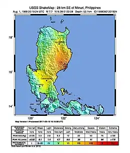
1968 Casiguran earthquake
The 1968 Casiguran earthquake occurred on 04:19:22 local time on August 2 with a moment magnitude of 7.6 and a maximum Mercalli intensity of IX (Violent). The thrust earthquake's epicenter was in Casiguran, Quezon (now part of Aurora province). A small non-destructive tsunami was generated and at least 207 people were killed. The majority of the deaths occurred in the collapse of a six-story building in Manila.
 | |
| UTC time | 1968-08-01 20:19:22 |
|---|---|
| ISC event | 817557 |
| USGS-ANSS | ComCat |
| Local date | August 2, 1968 |
| Local time | 04:19:22 |
| Magnitude | 7.6 Mw[1] 7.3 Ms[2] |
| Depth | 25 km (16 mi)[1] |
| Epicenter | 16.316°N 122.067°E[1] |
| Type | Thrust[3] |
| Areas affected | Philippines |
| Max. intensity | IX (Violent)[1] PEIS – VIII (Very Destructive) [2] |
| Tsunami | .3 m (1 ft 0 in)[4] |
| Foreshocks | 10+[3] |
| Casualties | 207–271 dead, 261 injured [4] |
Damage
In Manila, many structures that suffered severe damage had been built near the mouth of the Pasig River on huge alluvial deposits. A number of buildings were damaged beyond repair while others only suffered cosmetic damage. 268 people were reported to have died during the collapse of the six-story Ruby Tower, located at the corner of Doroteo Jose and Teodora Alonzo Streets in the district of Santa Cruz.[5][lower-alpha 1] The entire building, save for a portion of the first and second floors at its northern end, was destroyed. Allegations of poor design and construction, as well as the use of poor-quality building materials arose.[7] In the district of Santa Ana, one person was injured by debris from a damaged apartment building. Two more people from Aurora sub province and Pampanga died as a direct result of the quake. Around the town of Casiguran, there were several reports of landslides, the most destructive one at Casiguran Bay.
Aftershocks
The aftershock sequence throughout the month of August included many moderate shocks, including fifteen over 5.0 mb. The strongest of these occurred on August 3 with a 5.9 Ms event that produced intensities of III–IV in Manila.[8]
Aftermath and legacy
The former location of Ruby Tower in Santa Cruz district is now a memorial hall which stands today.[7][9]
See also
References
- "M 7.6 - Luzon, Philippines". United States Geological Survey. August 1, 1968. Retrieved August 27, 2017.
- "Destructive Earthquakes in the Philippines". phivolcs.dost.gov.ph. PHIVOLCS. Retrieved October 17, 2021.
- Su 1969, p. 459
- USGS (September 4, 2009), PAGER-CAT Earthquake Catalog, Version 2008_06.1, United States Geological Survey
- Moya, George P. (July 2, 2014). "When an earthquake hits Metro Manila". Rappler. Retrieved September 23, 2020.
- Ynares, Dr. Jun. "The Ruby Tower". Manila Bulletin. Retrieved September 23, 2020.
- Marianne V. Go (December 14, 2006). "Group warns vs substandard construction materials". The Philippine Star. Retrieved September 1, 2012.
- Su 1969, pp. 465–468
- "Of Manila Earthquakes and Ruby Tower". The Urban Roamer. April 27, 2019. Retrieved September 23, 2020.
Sources
- Su, S. S. (1969), "The Luzon earthquake of 1 August 1968: A preliminary report", Bulletin of the Seismological Society of America, 59 (1): 459–472, archived from the original on September 23, 2015, retrieved November 9, 2013
External links
- Casiguran Earthquake - 02 August 1968 – Philippine Institute of Volcanology and Seismology
- M7.6 - Luzon, Philippines – United States Geological Survey
- The International Seismological Centre has a bibliography and/or authoritative data for this event.
.svg.png.webp)
