1960 Agadir earthquake
The 1960 Agadir earthquake occurred 29 February at 23:40 Western European Time near the city of Agadir, located in western Morocco on the shore of the Atlantic Ocean. Despite the earthquake's moderate Mw scale magnitude of 5.8, its relatively shallow depth (15.0 km[7]) resulted in strong surface shaking, with a maximum perceived intensity of X (Extreme) on the Mercalli intensity scale. Between 12,000 and 15,000 people (about a third of the city's population of the time) were killed and another 12,000 injured with at least 35,000 people left homeless, making it the most destructive and deadliest earthquake in Moroccan history. Particularly hard hit were Founty, the Kasbah, Yachech/Ihchach and the Talborjt area. The earthquake's shallow focus, close proximity to the port city of Agadir, and unsatisfactory construction methods were all reasons declared by earthquake engineers and seismologists as to why it was so destructive.
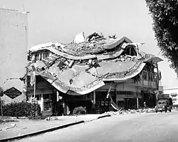
 Building damage in Agadir | |
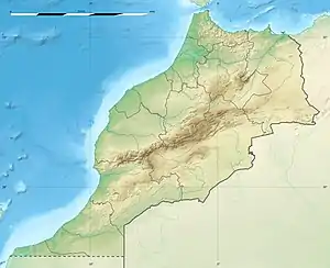
 Agadir Casablanca | |
| UTC time | 1960-02-29 23:40:18 |
|---|---|
| ISC event | 878424 |
| USGS-ANSS | ComCat |
| Local date | 29 February 1960 |
| Local time | 23:40:18 WET (UTC±00:00) |
| Duration | < 15 seconds[1] |
| Magnitude | 5.8 Mw[2] |
| Depth | 15 km [3] |
| Epicenter | 30.35°N 9.69°W[3] |
| Areas affected | Morocco |
| Max. intensity | X (Extreme)[4] |
| Foreshocks | 23 February III (Weak)[5] 29 February VI (Strong)[5] |
| Aftershocks | 22 March VI (Strong) 17 April VI (Strong)[5] |
| Casualties | ~ 12,000–15,000 dead[4] ~ 12,000 injured[6] |
Earthquake
While the shock was recorded by seismographs around the world, few of these stations were close enough to the scene to locate the epicenter with high accuracy, but with what information was available the instrumental location was determined to have been 8 kilometres (5.0 mi) to the north-northwest of the Kasbah. Macroseismic observations (establishing the locations with the highest observed intensity) placed the epicenter about 1 kilometre (0.62 mi) north of Yachech. A sequence of minor foreshocks preceded the main event. The first shock occurred on 23 February with an intensity of III or IV (Weak to Light) and on the day of the disaster, a more significant foreshock with an intensity of VI (Strong) caused alarm around the lunchtime hour.[5]
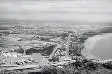
The main shock took place on the third day of the Muslim observance of Ramadan, immediately collapsing many hotels, apartments, markets, and office buildings. Underground water mains broke and sewer systems crumbled. The Kasbah of Agadir Oufla, a dilapidated fortress which had stood for centuries, crumbled on the side of a hill. With no water pressure and most fire stations having collapsed (killing their occupants) many fires were left burning in the resort city of Agadir with few firefighters and resources to fight them. With nearly seventy percent of the city in ruins, no rescue operations were able to be initiated or arranged from within Agadir. By morning the French army and sailors from the United States Sixth Fleet approached the coast, anchored, and prepared for the rescue process.[8]
British author Gavin Maxwell was staying in Morocco at the time of the disaster and his book The Rocks Remain opens with a vivid description drawn from his own experiences and those of others in the area, including important personages in the Moroccan government who numbered among his friends.[9]
Response
Mohammed V broadcast a request that all cities of Morocco prepare and send aid. He and his son, Crown Prince Moulay Hassan, flew to the area along with several cabinet ministers to observe the impact firsthand. In his role as Imam, he gave special dispensation to rescue workers to set aside the requirement to abstain from food and drink during daylight in Ramadan, but many workers nevertheless continued to fast.[9] Military planes from France and the United States flew into Agadir to assist with the relief effort. The Moroccan Army provided emergency aid and helicopters arrived from the Ben Guerir Air Base, around 249 km (155 mi) away.[10]
Upon arrival, Rear Admiral Frank Akers (commander of the U.S. fleet air arm in the eastern Atlantic and Mediterranean) toured the scene and reported that the Agadir hospital was in ruins. One of the many victims of the disaster was author and lawyer Robin Maugham. He was treated at a hospital in Casablanca for minor injuries he received while at the Saada resort when it collapsed – he had been trapped under a fallen beam for several hours.[9] The city of Agadir was evacuated two days after the earthquake in order to avoid the spread of disease.[11]

The rescue work was hampered both by the level of destruction and by the weather – temperatures were unusually high for the time of year, reaching 40 °C (104 °F)). Rapid putrefaction of the thousands of corpses created a foul and unhealthy atmosphere, and adherence to the Ramadan fast caused further strain on rescue workers. Many victims also refused medical treatment, believing that to accept it would constitute breaking their fast. Rescue workers were equipped with gas masks, and quicklime was spread over areas where rescue was considered hopeless, to destroy the rotting corpses – the risk of killing buried survivors as well being accepted. Disinfectant and DDT were sprayed over the ruins from lorries and helicopters to control disease and kill the swarms of flies which were attracted to the scene. The ruins also became infested by rats from the destroyed sewer network and rat poison was spread to kill them; larger animals, such as stray dogs and cats which fed on the human corpses, were shot. Looters were also attracted to the destruction; they were shot on sight and their bodies dumped in mass graves along with those of the victims. These measures were viewed as callous and brutal by those remote from the scene, but given the scale of the destruction and the rapid infestation of the ruins by potential carriers of disease, drastic measures were seen as necessary in order to prevent still further loss of life from epidemic.[9]
Damage

Construction in Agadir progressed rapidly between 1945 and 1955, with specific conditions that may have contributed to the high degree of destruction. Challenging designs were often undertaken with untrained workers, and a lack of good supervision was typical, along with an accelerated effort to finish the job. As there had been no serious earthquakes prior to 1960, construction in the city had been done without consideration of seismic activity. Masonry buildings of more than one story did not fare well, but reinforced concrete structures varied dramatically in their response. For example, some of the highest of this type collapsed completely, while a good number of them resisted the shock well, and some others escaped damage altogether. In most cases of complete collapse, the design of the buildings lacked with respect to building regulations, as these were not a primary concern of the architects and inadequate enforcement of the ordinances was also a factor.[12]
Many quarters of the city consisted entirely of buildings constructed from rammed earth. These had essentially zero earthquake resistance and disintegrated completely into dust. In these areas rescue work was impossible and survival rates were negligible; for example, in the Talbourdjt area, out of 5,000 inhabitants fewer than ten survived.[9]
Tsunami
The newspaper report on 2 March 1960 described how a tsunami was reported to have come ashore shortly after the earthquake, stating "A tidal wave curled in across the white beaches and lanced 300 metres/yards into the town. The city dock was cut in two, a Spanish shipmaster radioed."[13] A tsunami disaster was later refuted by a report from the American Iron and Steel Institute after a team of earthquake engineers, including Ray W. Clough from the University of California, Berkeley, surveyed the damage and building failures throughout the Agadir area in March 1960. The report of their findings stated that the port facilities suffered damage due to fairly uniform subsidence in the harbor area that was responsible for knocking over five large cranes, but no evidence of nor any reliable witness to large waves was found, with the exception of a Dutch freighter crew who stated that large swells in the harbor did cause the separation of their mooring lines at the time of the earthquake. A report in a 1964 issue of the Bulletin of the Seismological Society of America also denied the existence of a destructive tsunami because of a lack of evidence from a nearby tide gauge.[14][15]
References
- AISE 1962, p. 13.
- ANSS: Morocco 1960 .
- ISC-EHB Event 878424 [IRIS].
- Utsu 2002.
- AISE 1962, pp. 27–29.
- AISE 1962, p. 15.
- ISC-EHB Event 1960 [IRIS].
- Davis, Lee Allyn (2009). Natural Disasters, New Edition. Infobase Publishing. p. 77. ISBN 978-1-4381-1878-9.
- Maxwell, Gavin (1974). The Rocks Remain. Penguin Books. ISBN 978-0140039269.
- "2 Morocco Quakes Kill Hundreds". Los Angeles Times. 1 March 1960.
- "Fire and Havoc Grip Agadir After Quakes; Hundreds of Victims Still Trapped in Debris; Death Toll in City Placed at 1,000". Los Angeles Times. 2 March 1960.
- Despeyroux, J. (1960), The Agadir earthquake of February 29th 1960: behaviour of modern buildings during the earthquake | Association for Science Documents Information, Proceedings of the second World Conference on Earthquake Engineering : Tokyo and Kyoto, Japan, July 11–18, 1960, pp. 522, 527, 531, archived from the original on 13 August 2016, retrieved 17 February 2019
- "Tidal wave hits". The Milwaukee Sentinel. 2 March 1960. pp. A2. Archived from the original on 12 March 2016. Retrieved 29 February 2016.
- AISE 1962, pp. 8, 29, 52
- Berninghausen, W. H. (1964). "Tsunamis and seismic seiches reported from the Eastern Atlantic south of the Bay of Biscay". Bulletin of the Seismological Society of America. 54 (1): 441. Bibcode:1964BuSSA..54..439B. doi:10.1785/BSSA0540010439.
Sources
- AISE (1962), The Earthquake of Agadir, Morocco (1st ed.), American Iron and Steel Institute, ASIN B000H5AJDG.
- ANSS, "Morocco 1960: M 5.8 – Morocco", Comprehensive Catalog, U.S. Geological Survey
- International Seismological Centre, ISC-EHB Bulletin, Thatcham, United Kingdom
- Utsu, T. R. (2002), "A List of Deadly Earthquakes in the World: 1500–2000", International Handbook of Earthquake & Engineering Seismology, Part A, Volume 81A (First ed.), Academic Press, ISBN 978-0124406520.
External links
- A hotel, before and after the earthquake
- Thousands dead in Moroccan earthquake – BBC News
- Once... Agadir, a 1971 documentary film about the Agadir earthquake
- Agadir en 1960 et le tremblement de terre du 29 février 1960 (in French)
- Pictures of the earthquake
- Historical earthquakes – Agadir, Morocco – United States Geological Survey
- The International Seismological Centre has a bibliography and/or authoritative data for this event.