1939 Pacific hurricane season
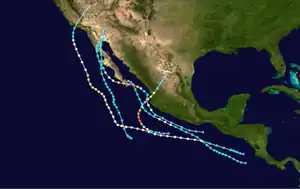
The 1939 Pacific hurricane season ran through the summer and fall of 1939. Before the satellite age started in the 1960s, data on east Pacific hurricanes was extremely unreliable. Most east Pacific storms were of no threat to land. However, 1939 saw a large number of storms threaten California.
| 1939 Pacific hurricane season | |
|---|---|
 Season summary map | |
| Seasonal boundaries | |
| First system formed | June 12, 1939 |
| Last system dissipated | October 25, 1939 |
| Strongest storm | |
| Name | Ten |
| • Lowest pressure | 930 mbar (hPa; 27.46 inHg) |
| Seasonal statistics | |
| Total storms | 10 |
| Hurricanes | 4 |
| Total fatalities | 93 |
| Total damage | $2 million (1939 USD) |
| Related articles | |
Systems
Hurricane One
On June 12, a hurricane was detected. The lowest pressure reported by a ship was 985 mbar (29.1 inHg). The hurricane was last seen June 13.[1]
Possible Tropical Cyclone Two
A possible tropical cyclone was located off the coast of Mexico on June 27. A ship reported a gale and a pressure of 1,006 mbar (29.7 inHg). The system was last seen on June 28.[1]
Tropical Cyclone Three
On July 19, a tropical cyclone was detected. A ship reported a pressure of 1,000.7 millibars (29.55 inHg).[2]
Tropical Cyclone Four
On July 29, a tropical cyclone was located midway between Manzanillo and Acapulco. It moved up the coast, and a ship reported a pressure of 1,000 mbar (30 inHg) on July 29 as the cyclone made landfall in the vicinity of Manzanillo.[2]
Tropical Cyclone Five
A small tropical cyclone was detected on August 31. A ship reported gales and a pressure of 1,003.3 millibars (29.63 inHg).[3]
Hurricane Six
A storm developed southwest of Cabo San Lucas on September 4 and paralleled the western coast of the Baja California Peninsula for two days, eventually curving northeast into the northern Baja California on September 6.[4]: 60 From September 4 to 7, moisture from the storm and its remnants brought heavy rain to Southern California. The storm delivered over a year's worth of rainfall to Blythe, while Imperial received more than two years' worth.[5] The flooding caused major damage in Mecca, California, and 3 feet (0.91 m) of water swamped Thermal.[6] Unusually heavy rains spread across the Colorado River Valley to western Arizona ahead of an approaching shortwave trough, with a maximum of 6.85 in (174 mm) falling in Truxton, Arizona.[4]: 57 Across the state, seven stations set 24-hour rainfall records between September 4–6, while the storm's rains would contribute to the rainiest September at 38 stations.[7]
Hurricane Seven
A tropical cyclone was first detected south of Acapulco on September 5. It intensified into a hurricane and moved northwestward. A ship sailing through the eye reported a pressure reading of 948 mbar (28.0 inHg). The tropical cyclone made landfall somewhere along the Baja California Peninsula. It dissipated inland over the northern part of the peninsula on September 12.[8] Remnants of this tropical storm, in association with a trough, caused rain of up to 4 inches (100 mm) in southern California on September 11 and 12.[5]
Tropical Cyclone Eight
On September 5, a tropical cyclone formed off the coast of Costa Rica. It also headed northwest and dissipated over the southern part of Baja California on September 15. The lowest reported pressure was 1,004 mbar (29.6 inHg).[8] From September 19 to 21, remnants of this tropical cyclone caused rain measuring up to 3 inches (76 mm) in Southern California.[5]
Hurricane Nine

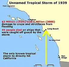
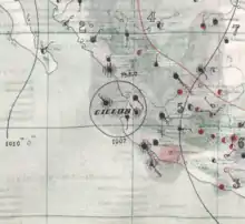
On September 14, a tropical cyclone formed off the coast of Central America. This tropical storm tracked northwestward and intensified into a hurricane.[6] The sea-level pressure dropped to 975 mbar (28.8 inHg) or lower. The hurricane recurved gradually to the northeast and weakened over cool seas. On September 25, this tropical storm made landfall near Long Beach, California, and dissipated inland.[8]
The tropical storm caught Southern Californians unprepared.[6] It brought heavy rain and flooding to the area, which killed 45 people.[8] At sea, 48 were killed. The storm caused heavy property damage amounting to $2 million (1939 USD) in total, mostly to crops and coastal infrastructure.[6]
Hurricane Ten

On October 23, a tropical cyclone formed south of Cabo Corrientes, Jalisco. It intensified and headed roughly due north. A steamer, the Nevadan, caught in the eye of this extremely intense hurricane, recording a corrected central pressure of 930 mbar (hPa; 27.46 inHg).[9] Even with modern tropical cyclone observation techniques available, this reading still qualifies this cyclone as one of the most intense on record and would likely have made it a Category 4 or 5 hurricane.[10] The steep pressure gradient between the Nevadan and the external hurricane conditions off of Manzanillo, Colima caused several tarpaulins to burst.[9] Other shipping was disrupted off the Mexican coast by the intense tropical cyclone.[11]
The hurricane made landfall near Cabo Corrientes on October 25 and dissipated shortly thereafter.[11] Onshore, the storm caused an extensive swath of damage. Homes were destroyed in the towns of Santiago Ixcuintla and Rosamorada in the Mexican state of Nayarit,[12] displacing hundreds of people.[13] In Puerto Vallarta, a strong storm surge flooded a section of the town, destroying several homes. Tobacco, corn, and rice crops in the region suffered considerable damage.[12] The strong winds downed power lines, resulting in the delayed dissemination of damage reports.[14] Although no exact casualty total was documented, reports indicated that the tropical cyclone caused a "few casualties". After the storm, US$6,000 was donated to help aid the displaced in the states of Nayarit and Jalisco, while doctors and nurses were sent to those areas.[15]
See also
References
- Hurd, Willis (June 1939). "North Pacific Ocean, June 1939" (PDF). Monthly Weather Review. 67 (6): 190. Bibcode:1939MWRv...67..190H. doi:10.1175/1520-0493(1939)67<190:NPOJ>2.0.CO;2. Archived (PDF) from the original on 2012-06-12. Retrieved 2011-01-18.
- Hurd, Willis (July 1939). "North Pacific Ocean, July 1939" (PDF). Monthly Weather Review. 67 (7): 226. Bibcode:1939MWRv...67..226H. doi:10.1175/1520-0493(1939)67<226:NPOJ>2.0.CO;2. Archived (PDF) from the original on 2012-06-12. Retrieved 2011-01-18.
- Hurd, Willis (August 1939). "North Pacific Ocean, August 1939" (PDF). Monthly Weather Review. 67 (8): 309. Bibcode:1939MWRv...67..309H. doi:10.1175/1520-0493(1939)67<309:NPOA>2.0.CO;2. Archived (PDF) from the original on 2012-06-12. Retrieved 2011-01-18.
- Smith, Walter (August 1986). The Effects of Eastern North Pacific Tropical Cyclones on the Southwestern United States (PDF) (Report). Salt Lake City, Utah: National Oceanic and Atmospheric Administration. Retrieved August 22, 2019.
- Williams, Jack (2005-05-17). "Background: California's tropical storms". USA Today. Archived from the original on 2009-02-26. Retrieved 2012-05-12.
- "A History of Significant Weather Events in Southern California" (PDF). National Weather Service Forecast Office San Diego. January 2007. Archived (PDF) from the original on 2016-01-20. Retrieved 2012-05-12.
- Greening, G. K. (September 1989). "Arizona Section" (PDF). Climatological Data. Asheville, North Carolina: National Centers for Environmental Information. 43 (9): 2. Archived from the original (PDF) on August 22, 2019. Retrieved August 22, 2019.
- Hurd, Willis (September 1939). "North Pacific Ocean, September 1939" (PDF). Monthly Weather Review. 67 (9): 356. Bibcode:1939MWRv...67..356H. doi:10.1175/1520-0493(1939)67<356:NPOS>2.0.CO;2. Archived (PDF) from the original on 2008-04-09. Retrieved 2011-01-18.
- Hurd, Willis (1940). "Additional Note on the Mexican West Coast Cyclone of October 23–25, 1939" (PDF). Monthly Weather Review. 68 (1): 29. Bibcode:1940MWRv...68Q..29H. doi:10.1175/1520-0493(1940)068<0029:ANOTMW>2.0.CO;2. Archived (PDF) from the original on 2012-06-12. Retrieved 2011-01-18.
- National Hurricane Center; Hurricane Research Division; Central Pacific Hurricane Center (April 4, 2023). "The Northeast and North Central Pacific hurricane database 1949–2022". United States National Oceanic and Atmospheric Administration's National Weather Service. A guide on how to read the database is available here.
 This article incorporates text from this source, which is in the public domain.
 - Hurd, Willis (June 1939). "North Pacific Ocean, October 1939" (PDF). Monthly Weather Review. 67 (10): 406. Bibcode:1939MWRv...67..406H. doi:10.1175/1520-0493(1939)67<406:NPOO>2.0.CO;2. Archived (PDF) from the original on 2012-02-05. Retrieved 2011-01-18.
- "Mexican Coast Is Swept By Hurricane". The Modesto Bee. Modesto, California. Associated Press. October 27, 1939. p. 2. Archived from the original on October 4, 2018. Retrieved August 31, 2014 – via Newspapers.com.

- "Hurricane Damages Towns In Mexico". The Modesto Bee. Vol. 20, no. 83. Corpus Christi, Texas. Associated Press. October 27, 1939. p. 1. Archived from the original on March 4, 2016. Retrieved August 31, 2014 – via Newspapers.com.

- "Storm Rips Mexico Coast". El Paso Herald Post. Vol. 59, no. 259. El Paso, Texas. United Press International. October 27, 1939. p. 5. Archived from the original on March 4, 2016. Retrieved August 31, 2014 – via Newspapers.com.

- "Mexico Speeds Storm Relief". Star-Monitor-Herald. Vol. 3, no. 16. Harlingen, Texas. Associated Press. October 29, 1939. p. 5. Archived from the original on March 7, 2016. Retrieved August 31, 2014 – via Newspapers.com.
