100-series highways (Nova Scotia)
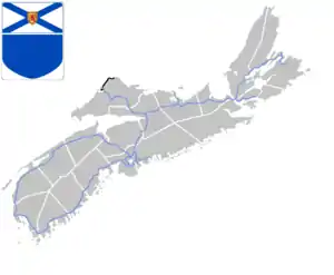
The 100-Series Highways are a series of arterial highways in the Canadian province of Nova Scotia.
 .svg.png.webp) Standard highway markers for Nova Scotia | |
 Map of the system | |
| Highway names | |
|---|---|
| Arterial (100-series) highways | Nova Scotia Highway 1XX (Hwy 1XX) |
| System links | |
A 100-series highway is a designation applied to a highway that can be a controlled-access expressway, Super-2, or fully divided freeway. The designation can also be applied in some cases to sections of uncontrolled access roads which are deemed strategically important and which will be upgraded in the future to controlled-access.
These highways connect major population centres such as the Halifax Regional Municipality and Cape Breton Regional Municipality with smaller population centres such as Yarmouth, Truro, New Glasgow and Amherst, as well as the neighbouring province of New Brunswick.[1]
Some of the 100-series highways also carry the Trans-Canada Highway designation on their routes.
The typical naming convention is to add 100 to a route containing a local trunk highway. E.g. Trunk 3 is a local trunk highway and Highway 103 is the 100-series highway running parallel to Trunk 3 in this corridor.
A 100-series freeway is roughly equivalent in function to the 400-series highways of Ontario, Autoroutes of Quebec, or the Interstate Highway System of the United States, albeit on a much reduced scale and amount of traffic. Many of these highways were developed during the 1960s–1990s as political projects and proved detrimental to rural railway service in the province, resulting in many rail line abandonments.
Route list
| Number | Length (km) | Length (mi) | Southern or western terminus | Northern or eastern terminus | Local names | Formed | Removed | Notes |
|---|---|---|---|---|---|---|---|---|
| 308.5 | 191.7 | Trunk 3 in Yarmouth | Hwy 102 / Trunk 1 in Lower Sackville | Harvest Highway | 1962 | current | Passes through the Annapolis Valley and Digby. | |
| 100.8 | 62.6 | Halifax | Hwy 104 in Onslow | • Veterans Memorial Highway • Bicentennial Drive |
1949 | current | Passes through Bedford, Lower Sackville, and Truro. | |
| 291.3 | 181.0 | Hardscratch Road in Yarmouth | Hwy 102 in Halifax | Fishermens' Memorial Highway | 1949 | current | Passes through Bridgewater, Liverpool, and Barrington Passage. | |
| 274.1 | 170.3 | New Brunswick border near Fort Lawrence (continues as NB 2) | Hwy 105 / Trunk 4 / Trunk 19 in Port Hastings | • Trans-Canada Highway • Miners Memorial Highway |
1964 | current | Passes through Amherst, Truro, New Glasgow, and Antigonish. | |
| 37.3 | 23.2 | Trunk 4 near Port Hawkesbury | Trunk 4 near St. Peter's | 1976 | current | |||
| 141.8 | 88.1 | Hwy 104 / Trunk 4 / Trunk 19 in Port Hastings | Marine Atlantic ferry terminal in North Sydney (continues as NL 1) |
• Trans-Canada Highway • Mabel and Alexander Graham Bell Way |
1970 | current | Ferry connection to Newfoundland and Labrador. | |
| 19.4 | 12.1 | Hwy 104 near New Glasgow | Northumberland Ferries terminal in Caribou (continues as PE 1) |
• Trans-Canada Highway • Jubilee Highway |
1968 | current | Ferry connection to Prince Edward Island. | |
| 43.2 | 26.8 | Dartmouth | Trunk 7 in Musquodoboit Harbour | 1978 | current | Extension proposed to Hwy 102 near Bedford.[2] | ||
| 12.9 | 8.0 | Trunk 2 in Halifax | Route 322 in Dartmouth | • Circumferential Highway • Highway of Heroes |
1960 | current | ||
| 9.9 | 6.2 | Hwy 103 in Hubley | Hwy 102 in Bedford | proposed[3] | — | |||
| 14.2 | 8.8 | Hwy 111 in Dartmouth | Hwy 102 near Fall River | 1971 | current | The highway has the only collector-express section in Atlantic Canada. | ||
| 28.3 | 17.6 | Hwy 105 near Sydney Mines | Trunk 4 in Sydney | Peacekeepers Way | 1970 | current | Passes through North Sydney. | |
| 6.1 | 3.8 | Trunk 2 in Springhill | Hwy 104 near Springhill | 1970 | current | |||
| 8.4 | 5.2 | Hwy 105 near Bras d'Or | Point Aconi | 1978 | current | |||
| ||||||||
Historical Note: Nova Scotia's original arterial highway number system had route number signs in the same shape as the U.S. Highway route number signs. These signs are now used for trunk highways.
Nova Scotia is planning to convert many 100-series highways to divided 4-lane highways during the 21st century, pending availability of funding.
See also
References
- Nova Scotia Road Map (Map). 1:640,000. Province of Nova Scotia. 2019.
- "Highway 107 Sackville-Bedford-Burnside Connector (Highway 107 Extension)". Department of Transportation and Infrastructure Renewal. Government of Nova Scotia. Retrieved April 7, 2020.
- Nova Scotia Transportation & Public Works (March 2006). "Focus Report for the Proposed Highway 113 Class I Environmental Assessment" (PDF). Nova Scotia Environment. Government of Nova Scotia. Retrieved April 7, 2020.