Štíty
Štíty (Czech pronunciation: [ˈʃciːtɪ]; until 1949 Šilperk; German: Schildberg) is a town in Šumperk District in the Olomouc Region of the Czech Republic. It has about 2,000 inhabitants. The historic town centre is well preserved and is protected by law as an urban monument zone. Štíty is known for its freestyle skiing centre.
Štíty | |
|---|---|
 View of Štíty | |
 Flag  Coat of arms | |
 Štíty Location in the Czech Republic | |
| Coordinates: 49°57′40″N 16°45′57″E | |
| Country | |
| Region | Olomouc |
| District | Šumperk |
| First mentioned | 1278 |
| Government | |
| • Mayor | Jiří Vogel (ODS) |
| Area | |
| • Total | 29.93 km2 (11.56 sq mi) |
| Elevation | 443 m (1,453 ft) |
| Population (2023-01-01)[1] | |
| • Total | 1,976 |
| • Density | 66/km2 (170/sq mi) |
| Time zone | UTC+1 (CET) |
| • Summer (DST) | UTC+2 (CEST) |
| Postal code | 789 91 |
| Website | www |
Administrative parts
Villages of Březná, Crhov and Heroltice are administrative parts of Štíty.
Etymology
The original German name was Schildberg (meaning "Shield Hill") and Šilperk in Czech (transcription from German). After World War II in 1947, the town was briefly renamed Žalkov, but soon changed its name to Štíty. The current name is derived from the original one and literally means "shields".[2][3]
Geography
Štíty is located about 15 km (9 mi) west of Šumperk and 53 km (33 mi) northwest of Olomouc. The municipal territory is divided between several geomorphological units. The southern part lies in the Zábřeh Highlands, the northwestern part lies in the southernmost tip of the Orlické Mountains, and the northeastern part lies in the Kłodzko Valley. A small northern part also extends into the Hanušovice Highlands. The highest point of Štíty is located on the slopes of the Strážka mountain, at about 830 m (2,720 ft) above sea level.
The historic centre of Štíty is situated on the promontory above the Březná river, which flows through the municipal territory and partly forms its southern border.
History
The first written mention of Štíty is from 1278. From 1308, the village was owned by the Sternberg family, however, they often leased the town to another aristocratic families. In 1334, it was first referred to as a town. In the early 15th century, it was one of the largest settlements in the region. During the Hussite Wars, the originally purely German town was partially settled by Czechs.[3]
In 1464, part of the Štíty estate was sold and joined to the Zábřeh estate. The second part was sold to Jan of Dalčice in 1480. During late 15th and early 16th century the town often changed its owners. In 1624, after the Battle of White Mountain, Štíty together with all his properties was confiscated from Jan Odkolek Jr. and assigned to the House of Liechtenstein, who annexed it to the Ruda estate.[3]
During the Thirty Years' War, the town was greatly devastated, especially by the Swedish troops in 1646, and the local castle was destroyed. In 1744, the town was completely burned down by the Prussian army.[3]
During the rule of the Liechtensteins, the town remained a craft centre for its surroundings, but lost its previous significance. The Liechtensteins administered the town to the fall of feudal system in 1848. Due to the establishment of textile factories in other parts of the region in the second half of the 19th century, local crafts found themselves in crisis and the town became one of the poorest in the region, whose livelihood depended mainly on agriculture.[3]
In 1938, Štíty was annexed by Nazi Germany and administered as part of Reichsgau Sudetenland. After the World War II, the German-speaking population was expelled.
Demographics
|
|
| ||||||||||||||||||||||||||||||||||||||||||||||||||||||
| Source: Censuses[4][5] | ||||||||||||||||||||||||||||||||||||||||||||||||||||||||
Sport
Štíty is known for its large freestyle skiing centre whose operator is the 2002 Olympic winner Aleš Valenta.[2][6]
Sights

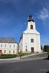
The landmark of Štíty is the parish Church of the Assumption of the Virgin Mary. Its predecessor was a wooden church from the mid-13th century, destroyed by Prussian army in 1744. The church was replaced by the current late Baroque structure built in 1755. The one-storey stone building of the rectory dates from 1794.[7]
The former town hall from the 16th century is one of the oldest houses in the town. The Renaissance town hall was modified into a Baroque burgher house in 1734. Today the house serves as an elementary art school and the seat of various associations. [7]
References
- "Population of Municipalities – 1 January 2023". Czech Statistical Office. 2023-05-23.
- "Mezi Lanškrounem a Štíty měla před 100 lety vzniknout dráha" (in Czech). České dráhy. 2012-11-22. Retrieved 2022-01-24.
- "Historie města Štíty" (in Czech). Lysá hora. Retrieved 2022-01-24.
- "Historický lexikon obcí České republiky 1869–2011 – Okres Šumperk" (in Czech). Czech Statistical Office. 2015-12-21. pp. 15–16.
- "Population Census 2021: Population by sex". Public Database. Czech Statistical Office. 2021-03-27.
- "Acrobat Park – accommodation, restaurant and sports". Acrobat Park. Retrieved 2022-01-24.
- "Památky a zajímavosti města" (in Czech). Město Štíty. Retrieved 2022-01-24.
- "Partnerská města" (in Czech). Město Štíty. Retrieved 2022-01-24.