< Transport 
Map of 1888 Paris on 2 sheets. Showing average length of bus lines, the routes and connecting lines
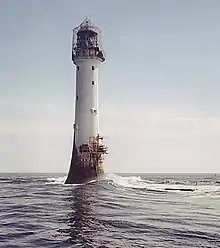
Bell Rock Lighthouse constructed on a dangerous rock submerged at most states of the tide
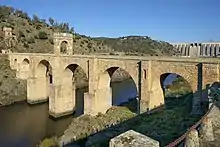
Alcántara Bridge
- Maps
- Lighthouse
- Viaduct
- Parking lot
- Overhead cables
Cost
- Cost-benefit analysis
- Passengers
- Subsidy - Roads are the most subsidised infrastructure especially controlled access highways (freeways, motorways).[1]
- Space
- Traffic flow
- Demand (induced)
The longest tram line in the world at 42 miles is Coast Tram (Belgium).
References
This article is issued from Wikibooks. The text is licensed under Creative Commons - Attribution - Sharealike. Additional terms may apply for the media files.