Yaiza is a village on the island of Lanzarote. It's the admin centre for the southern part of the island, but the main visitor attraction is that it's an access point for Timanfaya National Park. Only the southern half of the Park lies within Yaiza municipality but it's convenient to describe it all here. In 2022 the village population was 1098 and most of the municipality's population live further south in Playa Blanca.
Understand
- El día 1 de septiembre de 1730, entre las nueve y las diez de la noche, la tierra se abrió en Timanfaya, a dos leguas de Yaiza . . .
- - a survivor described the landscape erupting, and a new mountain arising.
- El día 1 de septiembre de 1730, entre las nueve y las diez de la noche, la tierra se abrió en Timanfaya, a dos leguas de Yaiza . . .
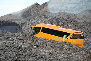
Lanzarote has always been volcanic. In 1730 the earth cracked open, and lava spouted from a line of volcanoes along the fissure. This mostly flowed northeast, sparing Yaiza but destroying nine villages and everything else in its path. It enlarged the island where it hissed into the sea, and slowly cooled to leave a black barren plain. There were other eruptions over the next six years, and another in 1824. The farmland was ruined and many emigrated.
These badlands - malpais - were declared a National Park in 1974 and given further legal protection in 1994. It's a bleak, haunting landscape that today is Lanzarote's main visitor attraction.
Get in
Yaiza is 24 km west of Arrecife via the main highway LZ-2.
Bus 60 runs from Arrecife via Playa Honda, Tias and Uga to Yaiza, continuing to Playa Blanca (for ferries to Fuerteventura). It's every 30 min M-F and hourly Saturday and Sunday.
Bus 161 runs from the airport (T1 and T2) via Puerto del Carmen to Yaiza and Playa Blanca, every 30 min M-F, hourly Saturday and every two hours on Sunday.
🌍 Supermercado the supermarket in village centre is the main bus stop.
Get around
You need wheels to explore the Park or anywhere off the main highway. A bike would do, but a hired car will cover more ground and shelter you from the sun and winds. Otherwise consider joining a tour, though you'll spend longer than you care for in gift shops.
See
- El Lomo del Cura is a hill just south of Yaiza village, with a track drivable by 2WD to the summit. It's tame if you've already seen the park.
- 🌍 Montaña Tremesana is a Kīpuka meaning an "island" that lava has flowed around but not engulfed - it's an older volcano that didn't erupt in the 1730s. This area on the south edge of the park is off-limits to individual visitors but guided walks come this way, see below.
- 🌍 Camel Museum is midway along LZ-67 park road. It's a free exhibition of how farmers in this arid terrain used camels. But their aim is to get you to ride one, a 20 min plod through the black desert which in 2023 cost €11 pp.
- Islote de Hilario Gate is at the junction of LZ-67 and the narrow lane to Islote de Hilario visitor centre. Tour buses pre-book so they skip line, other visitors can't do this so you may have to wait well over an hour as cars are trickle-fed in. No toilets or shelter here, and even less clever is that cars must queue on the through-road, so shunts are a danger. (Imagine Disney lousing up like this?) Once admitted, drive on for 2 km up to the visitor centre.
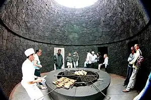
- 🌍 Islote de Hilario, ☏ +34 928 840056. Daily 09:00-17:00. Visitor centre, shop, bar and restaurant designed by César Manrique. Here you transfer to a bus which circles two volcano vents, with narration in Spanish, English and German. This has limited capacity so if seats are available (and the gate has done its sums right), do the bus tour first and save the centre for later. Only 10 m below your feet, the volcanic heat is 600 °C, so the docents do stunts like pouring water down a crack, to have it roar back as geyser steam. The restaurant El Diablo likewise has a schtick of naturally roasting your order, don't dare ask for a salad. Adult €12, child €6.
- 🌍 Pico Partido can be circled by a 3-4 hour trail starting by km 13 on the park road. However only 500 m up the trail are a pair of lava tunnels that you can scramble into, about 50 m deep.
- 🌍 Sima de Tinguatón are five chimneys or "throats" in the flank of Tinguatón, which erupted as late as the 19th century. Spelunkers may be able to descend them into the lava cave system below, most visitors will be content to drop a stone to gauge the depth. They're only 200 m from the park road, the difficulty is parking. You may have to park at the Pico Partido trailhead and walk up the road.
- 🌍 Timanfaya National Park Visitors' Centre (Centro de visitantes), ☏ +34 928 118042. Daily 09:00-16:00. Exhibition and AV presentations on the origins of the island, the volcanic activity that formed the park, and the flora and fauna of this arid terrain. Out back is a wheelchair-accessible walkway through the lava field. Free.
- 🌍 Caldera Blanca is more beige than white but stands out against the black lave field - it's pumice rubble. The simplest trail to the crater rim is from Mancha Blanca village to the east: drive up the unsealed lane to the parking lot, and then it's a 5 km hike, wear stout shoes. Montaña Caldereta is a side crater just before you reach the main one. You can circle both if time allows, the sunset views are impressive, but think about getting back in darkness.
- 🌍 Caldera Los Rostros is the west end of a ridge extending 1.5 km from Highway LZ-56 through Montaña Corujo. It's best to park at the highway junction rather than scrape the car finding a space along the access lane. The area between ridge and National Park Visitors' Centre is farmland, and ingenious farmers have plots right up the arid slopes.
- 🌍 Montaña Los Rodeos is reached by the same access lane: this is suitable for 2WD to the foot of the hill, but not the loop trail beyond. Three smaller volcanoes lie on its west flank and the group beyond is Pico Partido.
- Montaña De La Tabaiba is a three-caldera hill just east of the parking area for Los Rostros on LZ-56.
- 🌍 Montaña Cardona is best reached by hiking 2 km southeast from Los Rostros car park. The main attraction is the two lava tunnels just west. However since the trail is 4WD-drivable these are often used as a party room, garbage dump and latrine.
- 🌍 Volcán El Cuervo is reached from a free parking lot on LZ-56, then you walk about 600 m up a sand and gravel trail to the base. Take the right fork if you want to descend into the caldera, or either fork for a longer loop trail. The volcano is probably named cuervos (crows) for the thieves who target the parked cars. Montaña Negra is the black hill just east of the car park and highway.
- 🌍 Montaña Colorada is northeast of the same car park, or there is a closer car park 500 m north, equally thief-prone. The trail brings you to a field of bombas on the southeast mountain side, great volcanic boulders that rained down red hot. The summit and caldera are nothing special. You can trudge on across the lava field to Montaña Cardona but there are shorter access trails.

- 🌍 La Cueva de las Palomas and Cueva de los Naturalistas are two entrances to a 500 m lava tunnel. Signs forbid entry but most visitors venture in for a few metres to admire the spooky interior with sparkling rocks lit up by their cell phone. Traversing the tunnel is a 45 to 60-minute scramble where you want a headlight, to keep both hands free.
- Gateras means cat-flaps, formed when a lava cave collapses but the roof hinges downwards instead of fragmenting. A good example is Gatera de Sory in the lava field 500 m south of Cueva de Las Palomas / Los Naturistas.
- 🌍 Playa del Paso is a black beach with sea caves: the sea is too rough for swimming and there are strong currents. Get here by driving past Vulcano del Roja to the end of LZ-705 then hiking the 2 km dirt track across the lava field. Or hike 3 km along the coast trail from El Golfo, passing a natural arch midway.
- 🌍 El Golfo is a laid-back little village on the west coast. The beach is rugged black lava and the sea is rough. The "Playa del Paso" marked here on Google Map is simply the parking lot for the coastal trail.
- Charco Verde - Green Lagoon - is in an eroded caldera 300 m south of El Golfo. A lava shingle beach has formed across the caldera trapping a little brackish lake behind, green from algae and minerals, better photographed than tasted. Visitors in 2022 / 23 found the track from the village car park blocked off. You may be able to get a view by driving around the hill on LZ-703 to the south viewpoint, but this too may be closed and the police will fine anyone attempting to park.
- 🌍 Los Hervideros means "the boiled ones". The lava cliffs have been eroded into caves and pillars. When the tide is high and there's a strong wind from the west, the waves surging into the caves create blowholes above. In 2023 the turnoff lane and parking lot are closed by landslide, but you can park on LZ-703. The area is free and 20 minutes will be plenty.
- Highway LZ-703 remains closed in 2023 between Los Hervideros and Janubio because of landslide.
- 🌍 Salines de Janubio are salt pans. The 1730s lava flow closed off a sea inlet to create a lagoon. Over the following decades this dried out, and was panned commercially from 1895. The lagoon is replenished by raw sea water then fed into evaporation ponds, yielding up to 15,000 tons of salt per year. You can't enter the industrial area but there are viewpoints. Migratory birds visit the lagoon and ponds, but the salt company is tight-lipped about what they do whilst there.
- 🌍 Los Charcones are pools formed by the rocks. Some are dinky and you look for crabs, others are suitable for bathing in calm conditions, while others are exposed and the returning surf could sweep you out to sea. All of them are popular with sea urchins. In strong weather there are blowholes. Charcones are all along this coast but this is the best group, reached by a 2 km dirt track past an abandoned hotel. This track is nowadays closed to vehicles.
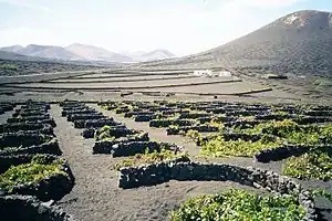
- 🌍 La Gería is a village amidst vineyards along the slopes of Montaña Chupaderos and Diama. It's a striking landscape where the black volcanic surface - you couldn't call it soil - has been "cupped" by a myriad little walls to trap moisture and break the wind to protect the vines. See below for the wine they produce, and tours.
Do
- Ruta de Tremesana is a guided hike from Yaiza north to Montaña Tremesana on the park boundary. Short hikes turn back here, the full day hike continues west to El Golfo.
Buy
- Supermercado de Yaiza is in village centre at C Vista de Yaiza 24, by the main bus stop. It's open M-Sa 08:00-21:00, Su 08:00-14:00 and has an ATM.
- Aloe Plus is a tourist-trap gift shop purporting to be a museum. It's west side of the village at C Vista de Yaiza 9.
Eat
- Manuel Filipino serves tapas and fast food at C Montañas del Fuego 6, 100 m north of the bus stop. It's open Tu-Sa 09:00-22:00, Su 10:00-20:00.
- La Bodega de Santiago, C Montañas del Fuego 27 (by north highway junction), ☏ +34 928 836204. Tu-Su 13:00-22:30. Great reviews for their grills and other trad fare.
- El Diablo at Islote de Hilario is open daily 12:00-16:00.
Drink
- Vineyards (Bodegas) around La Gería are La Gería (below), Rubicón, Statvs and La Querencia. The volcanic soil favours Malvasia grape varieties - historically called "Malmsey" but nowadays that only refers to sweet wines.
- Bodega La Geria, Carretera de La Geria km19, ☏ +34 928 173178. Daily 10:00-19:00. This has a tavern, shop, and guided tours - in English daily at 14:00. Tour €12.
Sleep
- There is no accommodation or camping in the Park.
- Timanfaya Cottage, C el Vallito 8, Yaiza (200 m west of bus stop), ☏ +34 638 491463. Pleasant welcoming pansiyon. B&B double €100.
- Hotelito La Era, C el Barranco 11, Yaiza (100 m south of bus stop), ☏ +34 928 830016. Friendly clean pansiyon near village centre. B&B double €100.
- La Casona de Yaiza, C del Valle de Fanauso 11, Yaiza (200 m south of bus stop), ☏ +34 928 836262. Charming but idiosyncratic pansiyon in a 19th century house.
- Casa de Hilario, C Los Rostros 5, Yaiza (500 m north of bus stop), ☏ +34 928 836262. Relaxing clean pansiyon near main highway junction. B&B double €120.
Connect
As of Oct 2023, Yaiza and its approach highways have 5G from MasMovil, Movistar and Orange, and 4G from Vodafone.
Go next
- Arrecife the capital has two offshore forts, one a museum and the other a modern art gallery.
- Playa Blanca is a small resort at the south tip of the island. Ferries sail to Fuerteventura.