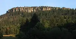
- This guide is about the Table Mountains in Poland, see also the Table Mountain National Park in South Africa.
The Góry Stołowe (Table Mountains in English) is a national park in Poland part of the Sudetes Range southeast of the Giant Mountains.
Towns
Understand

The Table Mountains National Park was established in the Stołowe Mountains in 1993. The highest peak of the range is Szczeliniec Wielki.
The Table Mountains owe their name to their specific structure, the shape of which is similar to the flat surface of the table. The current appearance of the range is due to relatively young tectonic movements and erosions that began in the Miocene and continue to this day. As a result, the upper part of the hills formed flat peaks.
Tourist information
- IT point of the Kudowski Center for Culture, Sport and Promotion - ul. Zdrojowa 44 - ☏ +48 74 866 13 87, ☏ +48 74 866 35 68
- Tourist Information and City Promotion Office - Rynek 9 - ☏ +48 74 866 94 13
- Tourist Information Point - Rynek 17 - ☏ +48 74 871 22 70
Get in
By plane
There are no passenger airports in the vicinity of the park. The nearest one is in Wrocław-Strachowice, Poland. It is about 117 km from the national park.
By car
The direct road leading to the park is provincial road 387, which connects Nowa Ruda with Kudowa-Zdrój. To the south of the range there is the national road No. 8, where its final section runs (border crossing in Kudowa-Zdrój, about 6 km from the park border).
Get around
See
- The Rock City (Skalne Miasto) in Szczeliniec Wielki
- Errant Rocks (Błędne Skały) in the Skalniak peak massif
- Skalne Grzyby and Radkowskie Skały
- The Łężyckie Skałki mountain clearing
- The old cross on Krucza Kopa
- Charles Fort and the Hundred Curves Road (Fort Karola i Droga Stu Zakrętów)
- Dinosaur Park in Karłów
- Museum of the Table Mountains National Park
- Open-air museum and religious buildings in Wambierzyce