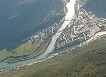
Otta is a town in Oppland. Otta sits at the confluence of Lågen and Otta rivers. The small town is an important junction in Gudbrandsdalen valley as the Otta valley joins the main valley. The Otta valley and river cuts deep into the central mountains almost to Geiranger and Stryn. Otta town sits between Reinheimen and Rondane mountain ranges.

Otta town at the confluence of Otta river (emerald, opaque as it brings meltwater from glaciers) and Lågen river from Lesja and Rondane-Dovrefjell plateau
Get in
By rail
By car
E6 from Lillehammer and Oslo from the south, or Trondheim from the north. Route 15 from Stryn in Sogn og Fjordane.
Get around
See
Altertavle.JPG.webp)
Altarpiece in Sel church
- Jørundgard (Along E6, 10 km north of Otta), ☏ +47 61233700, fax: +47 61233120, info@jorundgard.no. 20 Jun - 1 Aug: 10 am - 7 pm. A constructed medieval farm, complete with its own stave church. Built in 1991 for the filming of the movie Kristin Lavransdatter. Adults: kr 65, students: kr 60, children: kr 35.
- 🌍 Sel church (Sel kyrkje), Valley floor just north of Otta village (Close to road E6 at Sel). Wooden church, 1742. Colorful, decorated interior, particularly the rich altarpiece carved in wood, copied largely from Lesja Church.
- 🌍 Rondane range and national park (Road 27). 24/7. Rondane mountains was protected in 1962 as Norway's first national park. No road through the park but road 27 along the edge, access also from Høvringen at E6 north of Otta. free.
- Battle of Kringen (Slaget ved Kringen). Some 300 Scottish mercenary soldiers on their way to Sweden in 1612 were massacred by locals after the ambush at Kringen, a few kilometers downstream from Otta village. While the Battle had limited military signficiance, it has since become a part of folklore in Norway. There is a monument next to the main road.
Do

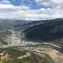
Snow-covered slopes of Rondane rising above Otta town (early May photograph).
- Sjoa Adventure (Along route 257 towards Ransverk), ☏ +47 93406500, info@sjoaadventure.com. Rafting in the Sjoa river, one of the best rivers for rafting in Europe.
Buy
Eat
Drink
Sleep
Budget
- Sjoa Vandrerhjem, Sjoa, ☏ +47 61236200, sjoa@hihotels.no.
Mid-range
- 🌍 Norlandia Otta Hotell, Ola Dahlsgate 7, ☏ +47 61210800, fax: +47 61210899, service@otta.norlandia.no.
Connect
Go next
- Rondane mountains
- Sogn og Fjordane: Luster, Stryn
- Møre og Romsdal: Åndalsnes, Geiranger
- Lillehammer
| Routes through Otta |
| Trondheim ← Dovrefjell ← | N |
→ Kvitfjell → Oslo |
| Måløy ← Lom ← | W |
→ END |
This article is issued from Wikivoyage. The text is licensed under Creative Commons - Attribution - Sharealike. Additional terms may apply for the media files.