Northland is the northernmost region in New Zealand. Whangarei is the only city in the area; the next biggest towns have a few thousand people. The Northland Region (governed by the Northland Regional Council) covers the area from Te Hana in the south to Cape Reinga at the northern tip of the North Island. Further south, towns such as Wellsford and Warkworth are now part of the Auckland Region in local government terms, but were historically part of Northland.
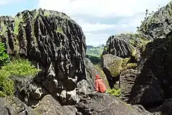
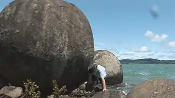
If you're looking for wonderful empty beaches in a subtropical-like setting, this is the best area in New Zealand. The east coast of Northland has long been a well-known holiday place, and the west coast is known for its spectacular natural phenomena: Tane Mahuta (huge, ancient kauri tree), untouched forests in Waipoua, Warawara, Omahuta Kauri Sanctuary and Puketi, the biggest concretions in the world (the Koutu Boulders and the world unique Wairere Boulders), the sand dunes of the North Hokianga and Ninety Mile Beach.
Regions
- Bay of Islands – historic area and very popular tourist destination
- Far Far North – the northernmost part of mainland New Zealand, including Cape Reinga and Ninety Mile Beach
- Hokianga – pristine, unspoilt, untouched, untamed
- Lower Northland – Kaipara and Whangarei districts
Cities and towns
- 🌍 Whangarei – the main centre and only city in the region
- 🌍 Dargaville – the main town in Kaipara District
- 🌍 Kaitaia – in the very far north, near 90 Mile Beach
- 🌍 Kerikeri – in the Bay of Islands, and has the oldest buildings in New Zealand
- 🌍 Opononi – village across the Hokianga Harbour from massive sand dunes
- 🌍 Paihia – historic town in the centre of the Bay of Islands, including the location where the Treaty of Waitangi was settled
- 🌍 Rawene – historic and picturesque village on the west coast's Hokianga Harbour
- 🌍 Russell – historic town in the Bay of Islands, and the first European settlement in New Zealand
- 🌍 Whangaroa – harbourside village north of the Bay of Islands
Other destinations

- 🌍 Cape Brett – 16.3-km walking track to an old lighthouse in the Bay of Islands
- 🌍 Cape Reinga – at the northern tip of New Zealand
- 🌍 Ninety Mile Beach – used as a road to Cape Reinga, it's actually only 58 miles long, but that's still very long
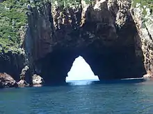
- 🌍 Poor Knights Islands – halfway between Whangarei and the Bay of Islands. They are a nature reserve and the surrounding waters are a marine reserve. You are not allowed to land on the islands, but the waters are a popular underwater diving location. They can be reached by charter boats from Tutukaka Harbour, 30 kilometres north of Whangarei. Rikoriko Cave is the world's largest sea cave. Several boats can enter the cave, and the acoustics are extraordinarily good. Rikoriko means dancing light in Maori and the light reflected from the water seems to dance on the roof of this cavernous natural wonder. See also Diving the Poor Knights Islands.
Understand

Māori tribes (iwi) in Northland say that their boats arrived in Northland in the 13th century, beginning their spread throughout the country. The British also used Northland as their starting point for their colonisation of New Zealand in the 19th century. New Zealand's first capital was Okiato (Old Russell) and the oldest European building in the country can be found in Kerikeri. Battles were fought between the Māori and the British throughout this area as the British restricted Māori rights and spread into Māori lands.
Despite its natural beauty and ample tourist attractions, Northland is one of the poorest regions of New Zealand. Economic deprivation is not readily apparent in tourist towns like Paihia and Kerikeri, but it can easily be seen in the Whangarei CBD and inland towns like Kawakawa and Kaitaia. Reasons include a lack of jobs, a low proportion of residents with qualifications, and a brain drain to Auckland. That said, the locals are as friendly as in the rest of country New Zealand, with people commonly greeting you with "kia ora" as they pass you on the street.
Northland is home to many walkable kauri (pronounced ko-ree) forests. These stately native trees are under threat from kauri dieback, a disease caused by a microscopic fungus spread by dirt particles on shoes. Please ensure you scrub and sanitise the soles of your shoes as you enter and leave forests where kauri trees grow. Brushes and sanitising solution are provided.
Get in
By air
Auckland is the main international gateway for travel to Northland. Air New Zealand operates domestic flights to Whangarei and Kerikeri (Bay of Islands). Barrier Air flies from Auckland to Kaitaia. Charter operators offer transport into the region tailored to your requirements.
By car
The Twin Coast Discovery Highway is Northland's scenic touring route starting and finishing in Auckland. Taking you to both coasts, this route showcases the diversity of the region.
By sea
Arrival to Northland by sea is spectacular - your coastal journey is bound to impress. Stunning headlands, bush-covered hillsides and long stretches of beach greet as you head for terra firma. If you are arriving by boat from overseas there are two official Ports of Entry into Northland.
By bus
- GreatSights operates a premium sightseeing tour to the Bay of Islands with daily departures from Auckland. Tours can be completed in one day, including a guided tour of the Waitangi Treaty Grounds and "Kings Dolphin Cruise" to Cape Brett and the famous "Hole in the Rock", or one way.
- InterCity is a national coach company and operates a number of daily departures to the Bay of Islands and other Northland destinations.
Get around
See

- Historic buildings The Historic Places Trust allows you to visit five historic places in the Bay of Islands and Hokianga: Kerikeri Mission Station and Stone Store; Pompallier Mission in Russell; Clendon House in Rawene; Mangungu Mission at Horeke; Te Waimate Mission at Waimate North.
- Koutu Boulders — biggest concretions in the world in Koutu, Hokianga
- Wairere Boulders — an enormous basalt flow just south of Horeke, Hokianga
- Sand dunes — windblown sculptures on top of sand dunes across the harbour from Opononi, Hokianga
- Omahuta Kauri Sanctuary (ecologically undisturbed forest) — see five of the dozen biggest kauri trees near Mangamuka Bridge in Hokianga
Do
- Cruise the Bay of Islands seeing the sights and viewing marine life. On some cruises you can swim with dolphins.
- Cycle the Twin Coast Cycle Trail. Runs for 87 km between Opua in the Bay of Islands and Horeke in the Hokianga.