Mount Nimba Strict Nature Reserve covers parts of Côte d'Ivoire and Guinea. It is an endangered UNESCO World Heritage Site. The reserve covers significant portions of the Nimba Range, a geographically unique area with unusually rich flora and fauna, including exceptional numbers of single-site endemic species, such as viviparous toads, and horseshoe bats. Its highest peak is Mount Richard-Molard at 1,752 m (5,750 ft), which is the highest peak of both countries.
Understand
The nature reserve on the Guinean side has 13,000 hectares, while the Ivorian side has 5,000. The Biosphere Reserve (Guinea) has 17,000 hectares.
Mount Nimba lies in remote region along the tri-nation border of Guinea, Côte d'Ivoire, and Liberia, far from their capital cities. The Liberian part of the mountain is greatly degraded due to former mining activities. However, the Guinean half of the ridge is highly protected; and therefore this part is still characterized by intact montane ecosystems, and unique species assemblage (as well as the smallest, Ivorian section).
History
The Monte Nimba Integral Nature Reserve was declared in 1943 in Côte d'Ivoire and in 1944 in Guinea . The Guinean sector was internationally recognized as a Biosphere Reserve in 1980 and, in 1981, was inscribed by UNESCO on the list of World Heritage sites; the site was expanded in 1982 to include the Ivorian sector. Adjacent to these reservations, that of Liberia has already been proposed to be included as well.
The reserve was inscribed in 1992 on the List of World Heritage in Danger because of the proposal to grant an iron mine to an international consortium and the settlement of a large number of refugees in the Guinean part of the hill. Although the Guinean government created a "Mount Nimba Environmental Management Center" and the boundaries of the area were redefined, in 1999 the mine project was still standing, although outside the protected region. The government, as investors, assured the international community that they will make every effort to maintain the ecological integrity of the site.
Landscape
The reserve includes Mount Nimba, the highest mountain in Côte d'Ivoire, and Guinea (1752 meters). It is located on the border between the two countries. Mont Nimba lies between the tropical forest and the West African savannah zone. It is part of an archipelago of peaks and plateaus, a secluded refuge covered by Guinean montane forest at a higher elevation, which rises steeply above undulating lowland forest plains.
Flora and fauna
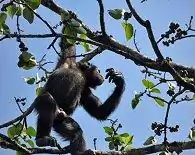
Mount Nimba is covered by dense forests, with mountain pastures at its foot. These habitats are especially rich in flora and fauna, with several endemic species such as the viviparous frog and chimpanzees that use stones as instruments.
The endangered pygmy hippopotamus, many species of monkeys, buffalo and duiker can also be found here. There are also said to be some herds of elephants.
Climate
Temperature changes extremely with altitude, with a daytime maximum ranging between 24 °C and 33 °C, and the nightly minimum can fall below 10 °C. Some parts of the reserve receive significantly less precipitation, due to rain-shadow effect of the high ridge. In general, southern slopes are moister than the leeward northern ones which are affected by dry Harmattan wind from the Sahara. The Nimba Range and the reserve have exceptional microclimatic diversity.
The wettest months are usually April to November (May to November on the peaks). There is marked fluctuation, but rainfall is usually heaviest from August to October. January is the driest month with an average rainfall of 20mm. In January and February, when dry, often heavily dusted winds blow from the desert. During most of the year, except in the dry season, a dense cloud cover above 850 m develops daily and covers half the mountain.
Get in
To visit the strict nature reserve is the best choice from Guinea, where a local tour operator organizes guided tours from Conakry.
Fees and permits
Get around
See
Do
Buy
Eat
Drink
Sleep
Lodging
Camping
Backcountry
Stay safe
Go next