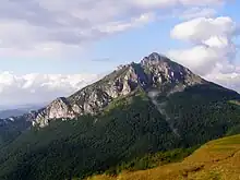
Little Fatra (Malá Fatra - Slovak pronunciation: [ˈmalaː ˈfatra]; also Lesser Fatra, Polish: Mała Fatra) is a karst mountain range in the Western Carpathians in the north-west of Central Slovakia.
It lies between Nitrianske Pravno, Strečno, Martin and Zázrivá.
Understand
History
Landscape

The mountain range contains one of the most iconic/photogenic mountains in Slovakia, Veľký Rozsutec. Several other mountains belong here too, such as Malý Rozsutec (1343m), Veľký Kriváň (1709m) and Malý Kriváň (1671m).
Flora and fauna
Climate
Get in
- Bus from Žilina to Terchová. Buses leave in Žilina from the main bus station southeast of the train station. The first one departs at 05:23 with several connections per hour. The last one departs at 20:25. From Terchová you can then walk 2 km to the entry to Jánošíkove Diery.
- 🌍 Štefanová. The small village has parking spots for tourists, from which most of the area can be explored by feet.
Fees and permits
Get around
See
Do
Most people visit the park for its nature areas, such as the following:
- 🌍 Jánošíkove diery (Start at Terchová, Hotel Diery, continue towards the mountains at the back of the valley.). A not too difficult, but picturesque ravine.
- 🌍 Veľký Rozsutec (Most common access is from village Štefanová (altitude approx. 650m) or Terchová (600m, goes through "Jánošíkove diery"), following a ravine, continuing around Malý Rozsutec and up. Usually 2½-3 hr hike up (in places quite steep, but no significant cliffs).). Measuring 1610m, the mountain provides great views from both summit and during the trip there.
- 🌍 Malý Rozsutec (Most of the hiki is common with Veľký Ruzsutec, you just split at the beadow/saddle Medzirozsutce (between the mountains) and follow the signs. The hike requires some climbing of steep rocks - not too hard for normal hikers, but families should consider this. It's manageable to combine this with the bigger mountain hike in a day.). This small brother of the above is equally interesting and in some places technically even more demanding.
- 🌍 Vrátna valley (Vrátna dolina) (Follow the road from Terchová). A valley, which is one of the most visited tourist and ski destinations in Slovakia.
- 🌍 Malý Kriváň and Veľký Kriváň (Most commonly, start is at Vrátna dolina, from where it is possible to shorten the hike up by using the cablecar to Snilovské sedlo (saddle, approx. 1500m). The way through forest is somewhat of an exhausting start. Follow the red signs to reach the peaks and back. This medium-difficulty hike takes 8-9 hr (without taking the cablecar).). Pair of nearby mountains, where "Veľký Kriváň" is the highest one in the mountain range.
- 🌍 Šútovo waterfall (Šutovský vodopád) (Start at the Šutovo village, "Šútovská Fatranka" hut, follow blue signs. The hike should take approx. 45 min.). 4th highest Slovak waterfall, a short hike away from Šútovo village.
- 🌍 Stoh. A prominent peak providing great views of the surroundings, especially of "Veľký Rozsutec".
Buy
Eat
Drink
Sleep
Lodging
Hotels and guesthouses are available in the villages of Terchová, Belá and Zazriva.
Camping
Wildcamping and open fires inside the national park are not allowed in order to protect the nature and wildlife.
- 🌍 Camping Belá - Nižné Kamence (just off the main road Zilina-Terchova near Nižné Kamence), ☏ +421 415695135, camp@bela.sk. 2 people with tent €10.
Backcountry
A few cabins (knowns as chata) are available inside the national park. Most have shared dorms at good value for hikers.
- 🌍 Chata pod Chlebom, ☏ +421 905861042, chatarka@chatachleb.sk. 30 minutes hiking from the chairlift station at Snilovské Sedlo. Reservation via email only, which is recommended in high season. If you intend to arrive after 18:00, let them know beforehand what time you will come. Open year-round. €10 per person, €2 discount if you bring your own bedding.
- 🌍 Chata na Gruní, on the trail between Vratna and Stefanova, ☏ +421903524200, chatagruni@gmail.com. This chata is at a convenient half-way point if you intend to visit the area around Velky Rozsutec as well as Velky Krivan, and definitely a good option if you intend on hiking the entire ridge. Dorm with breakfast €13, with dinner €18.
- 🌍 Chata pod Kľačianskou Magurou, ☏ +421 907338871, miriam@tipnet.sk. Dorm €12.
- 🌍 Chata pod Suchym (halfway on the trail from Strecno to Velky Krivan), ☏ +421 918523200, info@chatapodsuchym.sk. Reservation via email only. If you intend to arrive after 19:00, let them know via SMS. Dorm €12, with own bedding €10.
Stay safe
It is possible to encounter bears, wolves and lynx in the area, though they tend to avoid busy trails. Make sure you know what to do if you encounter one.
Go next
Žilina | Martin | Ružomberok
Great Fatra | Low Tatras | High Tatras