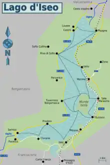
Lake Iseo (also known as Sebino - Lago d'Iseo in Italian) is in the eastern part of Lombardy, Italy.
Understand
The place
Lake Iseo is located between the provinces of Bergamo and Brescia, and the main waterway that flows into and out of it is the river Oglio. The upper part of the lake and the western shore are characterized mostly by a small stretch of coastline bordered by mountains, among which the Monte Guglielmo (1,957 m above sea level) between Zone and Marone and Mount Bronzone (1,334 m asl). Characteristic of the upper part of the lake, especially between Riva di Solto and Castro, are the gorges: vertical slabs of rock overhanging the water.
When to go
Tourist season spans from May to September.
Historical notes
Thanks to findings in the bottom of the lake, we now know that the area was inhabited in prehistoric times.
During the Roman Empire the area grew in importance and baths were built in Predore and Clusane (the latter remain the only walled arches).
After the descent, in 1161, of Frederick Barbarossa, the area experienced a period of continuous struggle between the Guelphs and Ghibellines.
In 1859, all city-states around the lake's area officially became part of the Kingdom of Sardinia.

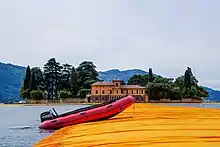
From June 18 to July 3, 2016, the Bulgarian-American artist Christo has created a series of floating walkways, The Floating Piers on the waters of Lake Iseo. The installation consisted of about 3 km of 16 m wide floating pontoons consist of cubes of high density extruded polyethylene covered by an orange synthetic fabric. Piers are around 4, the first, half a kilometer long, linking Sulzano and Peschiera, the second, about 1 km from Peschiera headed for the island of San Paolo, but before reaching it branched into two (700 and 250 m) creating a sort of triangle and forming a circumnavigation around the small private island. Christo and his wife Jeanne Claude had first developed this project for the mouth of the Rio de la Plata in Buenos Aires, but the local authorities never granted the necessary permissions. In 1975 it was the turn of Tokyo, but also in this case the Japanese authorities denied permission.
Cities
Urban centers
Eastern shore (from South to North)
- Paratico - between Franciacorta and lake Paratico has a nice, long walk by the lake that connects the hamlet of Tengattini in Sarnico.
- 🌍 Clusane - fishing village known by the epithet of the country-baked tench, owns a 15th-century castle (Castello Carmagnola) from which you can have a beautiful view of the lake.
- 🌍 Iseo - town in the southern part of the lake, with a beautiful castle and a square with many historical buildings and monuments as the first non-equestrian monument dedicated to the Hero of Two Worlds, Giuseppe Garibaldi.
- Pilzone - small village from where the Via Valeriana starts.
- Sulzano - this town is important for its service of non-stop ferries that connects with the Mount Island, is also important for its waterfalls.
- Sale Marasino - With its lakeside villas, is often remembered for the festival for brains in which she was awarded the largest pumpkin and are organized based on the result menu.
- Marone - important for wool and for the extraction of dolomite, the town is connected with Toline (Pisogne) from a cycle path which offers charming views of the lake.
- Pisogne - between mountain and lake, Pisogne is a town that has encouraged tourism through the redevelopment of the lakefront, mainly pedestrian today.
Western shore (from South to North)
- Sarnico
- Predore
- Tavernola Bergamasca
- Riva di Solto - fishermen village hosting a unique geologic formation the Bogn reachable from the village by a short walk north on the lakeside. the Bogn is a unique formation and a beautiful place for a swim
- Castro
- Lovere - picturesque village, hometown of Giacomo Agostini
- Costa Volpino