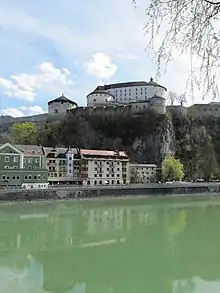
Kufstein is city in the Austrian state of Tyrol with a population of about 20,000 inhabitants, making it the second largest city in Tyrol after its capital Innsbruck. It is flanked by the Brandenberg Alps in the northwest and the Kaiser Mountains (Kaisergebirge) in the southeast. Kufstein is located along the river Inn in the Lower Inn Valley (Inntal). Most travellers visiting the Austrian Alps pass through Kufstein either by train, bus or car as it is the first city south of the Bavarian border. Kufstein is known for its fortress, and is also associated with one of the best known German language folk songs - the Kufstein Song (das Kufsteinlied) - which rose to popularity in the 1960s.
Understand
Archaeological findings in the Tischofer Cave in Kaisertal near Kufstein denote a settlement of the area more than 30,000 years ago, the oldest traces of human habitation in Tyrol. Incorporated into the Roman Empire in 15 BC, the Inn river formed the border between the Roman provinces of Raetia and Noricum.
The remote Kaisertal in Kufstein until recently was the last settled valley in Austria without transport connections, prior to the completion of a tunnel road in 2008. North of the town, the Inn river leaves the Northern Limestone Alps and enters the Bavarian Alpine Foreland.
The town area comprises several small lakes, such as Pfrillsee, Längsee, and Hechtsee; Egelsee and Maistaller Lacke are protected nature reserves.
The municipal arrangement comprises the cadastral communities of Kufstein, Morsbach and Thierberg; the town itself is divided into five quarters (Zentrum, Sparchen, Weissach, Endach, and Zell).
Get in
By train
Kufstein can easily be reached by train. With the 🌍 Kufstein Railway Station (Bahnhof Kufstein). being a local railway hub, Kufstein is served by local, regional, night, long-distance, and high-speed (WESTbahn, ICE and Railjet) trains (https://www.oebb.at/en/fahrplan).
See the overview for rail travel in Austria for a general overview.
By plane
The largest international airport nearby is Munich Airport (MUC IATA) (121 km) and is easy to reach by train. Innsbruck (INN IATA) (86 km) and Salzburg (SZG IATA) (104 km) have smaller international airports and are also connected by public transit.
🌍 Kufstein-Langkampfen Airport, Kufsteiner Str. 42, A-6336 Langkampfen (ca. 3 km to the south west of the city centre), ☏ +43 5372 63833. This airfield accommodates gliders, motorized gliders, ultralight and single engine airplanes up to 2,000 kg.
By car
One-way roads and expansive pedestrian zones make driving into town unattractive. There are parking fees throughout the city center.
- From the North (from Germany) using the Autobahn A93 Rosenheim / Dreieck Inntal to Kufstein, Exit Kufstein Nord.
- From the South using the Autobahn A12 (Innsbruck - Kufstein), Exit Kufstein Süd.
By bike
The Inn cycle path (Inn-Radweg) passes through Kufstein, leading from the upstream Tyrolean valleys down to the Danube River where it connects to the Danube cycle path.
Get around
Kufstein is fairly small, and all tourist attractions can easily be reached by foot.
Bikesharing stations from Regiorad are spread around town.
Four urban bus lines and many regional buses (https://www.vvt.at) cross the town with nearly all stopping at the bus station next to the train station.
Numerous electric cars are available for Carsharing throughout the town (https://www.beecar.at).
See


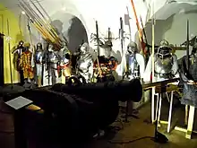
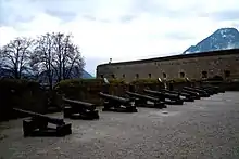
- 🌍 Kufstein Fortress (Festing Kufstein), Festung 2 (Festungsbahn, funicular railway), ☏ +43 5372 66525. 9:00-17:00 daily. The main landmark of Kufstein, its 13th century fortress sits on a hill overlooking the city 507 m above sea level. In its early history it was controlled by the Bavarians, first under Bavarian Duke Ludwig and the bishop of Regensburg, from 1415 onward by Duke of Bavaria Louis VII. The strategic importance of the fortress made it a frequent battleground throughout history between Bavarian and Tyrolean armies. Ironically, Kufstein transitioned peacefully from Bavaria to Tyrol when the son of Bavarian emperor Ludwig gifted the city to his newly wedded wife Margarete, Duchess of Tyrol, in 1342. The peace didn't last long however, and in 1363 the Bavarians attacked the city and took control of the fortress from the Tyroleans. Control switched back to Tyrol after emperor Maximilian I besieged the city in 1504, and expanded the fortress with the addition of the massive round tower constructed between 1518 and 1522. The increased defensive capabilities of the fortress successfully held back the Bavarians until 1703, an occupation that lasted little over a century until the Austro-Hungarian Empire finally regained control in 1814. It then served as prison for Hungarian political prisoners. Since modern times the fortress houses the City Museum of Kufstein, and is frequently used for concerts and other cultural events.
- St. Vitus' church. The original church dates back to 788. The choir of the present day church was built around 1390 to 1420, with the three-nave hall was built around 1500. In the 17th century, the interior was redone using baroque aesthetics. There are many frescoes - some dating back to the 15th century, and some modern.
Do
Cycling, hiking, rock climbing, swimming in alpine lakes, and nearby skiing/snowboarding in winter are popular activities.
- Ride the Kaiserlift chair lift for a hike and meal at a mountain hut.
Buy
- 🌍 Buch-Café im Lippott Haus, Unterer Stadtpl. 25, 6330 Kufstein, Austria. Bookstore + Cafe.
- 🌍 Riedel, Weißachstrasse 28-34, 6330 Kufstein, ☏ +43537264896.
Eat
- 🌍 La Crusca, Südtiroler Pl. 2, 6330 Kufstein, ☏ +43 664 1820431.
- 🌍 onnumara cigköfte, Oberer Stadtpl. 5b, 6330 Kufstein, ☏ +43 660 9701010.
Drink
- 🌍 Inncafe Hell (Kaffehaus, Konditorei), Unterer Stadtplatz 3 (old town / Innpromenade), ☏ +43 5372 62433.
- 🌍 Inner, Südtiroler Pl. 1, 6330 Kufstein.
- 🌍 das Kleinod, Kaiserbergstraße 17 / 2, 6330 Kufstein, ☏ +436645205305.
- 🌍 BAU! Kufstein, Marktgasse 14, 6330 Kufstein.
Sleep
- 🌍 Hotel Gisela, Südtiroler Platz 4, ☏ +43 676 7395322, info@hotelgisela.at.
- 🌍 Aparthotel Andreas Hofer (Apartments, Ferienwohnungen), Hötzendorferstraße 2, ☏ +43 5372 6980, fax: +43 5372 698090, info@ferienwohnung-kufstein.at.
- 🌍 Hotel Goldener Löwe (Hotel Kufstein), Oberer Stadtplatz 14, ☏ +43 5372 62181, fax: +43 5372 621818, hotel@goldener-loewe.at.
- 🌍 Beim Dresch, Oberweidau 2, Erl, ☏ +43 5373 8129, fax: +43 5373 8129-3, anker@dresch.at.
Go next
- 🌍 Innsbruck — state capital of Tyrol and largest city in the Alps
- 🌍 Igls — between Innsbruck and the 🌍 Patscherkofel mountain
- 🌍 Eng — the largest alm in Europe and one of the most remote settlements in the Alps
- 🌍 Hall in Tirol — historic salt mining city with the best preserved old town centre in western Austria
- 🌍 Wattens — home of the Swarvoski Crystal Company and their museum, the world famous 🌍 Crystal Worlds
- 🌍 Schwaz — famous for its silver mine