Karratha is a city in the Pilbara region of Western Australia, with a population of 17,013 in 2021. It's entirely modern, built from 1968 to house mining and port workers - Dampier is the port. The main reason for other visitors to linger, apart from urgent car repairs on the hot dusty road to Broome, is to view the petroglyphs in Murujuga National Park.
Understand
This area was traditionally the home of the Yapurarra. The coast was explored by Europeans from the 17th century, one of them being William Dampier (1651-1715) who gives his name to an island and small port. Settlement for livestock farming got underway in the 19th century and led to conflict with the Aboriginals. When two police officers and a pearling worker were murdered in 1868, reprisals led to the Flying Foam Massacre - casualties are debated but it effectively wiped out the Yapurarra.
Livestock was exported via Dampier and other small ports, and not much else happened until the 1960s, when vast reserves of iron ore and other minerals were discovered inland across Pilbara. A series of mining towns sprang up, railways were built to the coast, and the ports grew into modern industrial zones. Karratha was built as a new town from 1968, and rail and road causeways linked it to Dampier, no longer on an island but on what's now called the Burrup Peninsula. Iron ore is still big business and then in the 1980s the North West Shelf oil and gas field was discovered.
This has sucked in a huge workforce who are mostly FIFO, "Fly in, fly out." They work a "swing" of say two weeks solid then are flown home for a week off. Their families don't relocate here, no company could pay them enough, so they stay in camp - trailer parks or simple motel-type accommodation. They're decent hard-working folk but have no long term commitment to the town.
🌍 Karratha is Calling is the Visitor Centre, on De Witt Rd 500 m south of the shopping centre. It's open Tu-Sa 10AM-2PM.
Get in
Karratha has several flights a day from Perth by Qantas and Virgin. They take two hours non-stop and you might pay $600 return. Alliance don't fly here.
Local flights by Aviair are from Newman, Paraburdoo, Port Hedland and Broome.
🌍 Karratha Airport (KTA IATA) is 14 km northwest of Karratha and 5 km southeast of Dampier. The terminal is small but modern, with car rental from all the major companies.
Integrity Coaches run 3 nights a week from Perth, taking 25 hours along the coast via Dongara, Geraldton, Carnarvon and Exmouth. The bus stop is on Welcome Rd outside the shopping centre, and the adult fare in 2022 is $600 return. These buses continue east to Port Hedland and Broome.
By road from Perth follow the North West Coastal Highway. This continues east to Port Hedland, where it meets the Great Northern Highway via Mount Magnet and Newman, and continues to Broome.
Get around
PTA Bus 881 runs 2-3 times a day east from Dampier to Karratha (45 min), Roebourne, Wickham and Point Samson; the 880 is the westbound service.
🌍 Karratha Shopping Centre on Welcome Road is the stop for these and intercity buses, and the closest thing to a downtown hub in this strung-out settlement.
Taxis wait outside the Shopping Centre. Operators are Karratha Taxis (+61 131330), Karratha Silver Taxi (+61 135060) and Premier Taxi (+61 439 747 800).
You need your own wheels to explore the National Park. Rent a car at the airport: 2WD gets you most places, including Deep Gorge, but you need high-clearance 4WD for the top of Burrup peninsula.
See
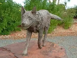
- 🌍 Red Dog is the fellow that greets you at the entrance to Dampier. He was a cattle dog (1971-79) that ranged independently across Pilbara, loping along or hitching rides, with several owners but adopted by the community at large as a true Australian free spirit. Then someone poisoned him, and his status as a "sight" says it all about Dampier's other attractions. The residential area is nondescript, while north is the ugly dusty port. Turn back 1.5 km for the start of Burrup Rd, the route north up the peninsula.
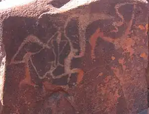
- 🌍 Ngajarli or Deep Gorge has a remarkable collection of Ngarda-Ngarli Aboriginal rock engravings and other artefacts - some over 47,000 years old. You explore it along a 700-metre boardwalk, accessible free 24 hours but with the best viewing in afternoon light. The gorge is within the detached southern part of Murujuga National Park.
- Hearson's Cove is a scenic beach 1 km east of the Ngajarli turn-off, suitable for swimming at high tide. It has public toilets, which Ngajarli doesn't. It's not within the Park: barbecues are permitted but not camping.
- Staircase to the moon is a natural effect seen on the Pilbara coast March-Oct on the full moon spring tides. Water caught between the ripples on the mudflats exposed at low tide creates the image of a golden staircase towards the rising moon. You need a southeast-facing view, and Hearson's Cove is about the best spot. Viewing times are published locally, eg by the Visitor Centre.
- 🌍 North West Shelf Visitor Centre explains the huge natural gas facility west side of the peninsula. Hours vary, but usually Wednesdays 9AM to noon.

- Mount Wongama is a lookout reached by a turnoff from Burrup Rd. Look north, you don't want to look at the industry west. This turn-off is far as you should venture with 2WD. The road continues by Withnell Bay and becomes rough: you need high-clearance 4WD to reach Conzinc Bay, and Aremvee Beach where camping is permitted. North coast of the peninsula, a narrow channel separates Dolphin Island.
- 🌍 Murujuga National Park northern section occupies the north of the peninsula.
- 🌍 Dampier Archipelago is a group of 42 islets west and north of Dampier. They have many fine beaches and boat trips visit for marine life, diving, snorkelling and fishing. Camping is permitted.
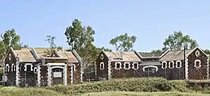
- 🌍 Roebourne east on the main highway was a gold-rush town in the 1880s then lapsed into slumber. It has several historic buildings of that era, including the old gaol which now houses the Visitor Centre.
- 🌍 Cossack is a small village north of Roebourne with basic accommodation. This is another beach for seeing the "staircase to the moon" as it has a view southeast, while northeast is the disused lighthouse on Jarman Island. Cossack has a museum, and near the turn-off is a memorial to Red Dog, buried in the boonies hereabouts.
- 🌍 Point Samson is the resort village at the end of the sideroad.
- 🌍 Montebello Islands are a group of 174 islets some 200 km west of Dampier, so they're beyond a day trip. Boat tours sometimes visit. They're a wildlife reserve from which cats and rats have been removed, and indigenous species re-introduced. Vodka Beach on Trimouille Island is the preferred camping spot, but don't dig too deep to build your sandcastle. In the 1950s Britain tested atomic bombs here, and there is residual contamination. For Barrow Island to the southwest see Onslow.
Do

- Beaches near town are east along Searipple Rd. At its foot a staircase leads down to the beach. Continue 3 km east on Mystery Rd to reach Back Beach, which has a boat ramp.
- Yaburara Heritage Trail is a 3.5 km walk between Tank Hill Lookout by the Visitor Centre and the Leisureplex.
- Red Earth Arts Precinct is on Welcome Rd opposite the shopping centre. Its auditorium can be configured for theatre, live music or cinema. Box Office is +61 8 9186 8600.
- Golf: Karratha Country Club is north side of town off Searipple Rd. Blue tees are 5891 yards, par 72.
- Karratha Leisureplex is off Dampier Hwy 1 km east of town centre. It has a gym / fitness centre and pool; a one-day drop in without membership is $20.
- Diving: Pilbara Dive and Tours are based in Karratha 1 km west of the shopping centre. They offer training, and shore- and boat-based diving around the Dampier islands.
- Nickol Bay Speedway is 5 km from Dampier, facing the airport across the lagoons. Race meetings are April-Sept.
- Horse-racing: Roebourne Races has meetings in June and July.
Buy
- Karratha City Shopping Centre has Woolworths (open daily 7AM-9PM) and ATMs.
- Dampier has an IGA on High St, open M-Sa 8AM-8PM. The food and liquor store next to it keeps the same hours.
Eat

- Lo’s, The Quarter Shop, 24 Sharpe Ave (north side of Shopping Centre), ☏ +61 438 186 688. 6AM–4PM. Reliable place for breakfast or lunch.
- Hearson's Bistro is within the Ibis hotel, open daily noon-2PM, 6PM-9PM.
- Bollywood Lounge at 23 Sharpe Ave gets mixed reviews. It's open daily 5PM-9PM.
- Point Samson and Cossack don't have free-standing restaurants, but Wickham on the access highway has Rambla bar and bistro.
Drink
- Karratha has a handful near the shopping centre. choose from Florita Wine Bar, Blanche Bar, Sweet but Pyscho, Evolution or others.
- 🌍 Northwest Brewing Company, 100 Mooligunn Rd, Karratha, ☏ +61 8 9197 2214. Tu 4PM-10PM, W-Su 11AM-10PM. Microbrewery and pub with good selection of ales.
Sleep

- Karratha Backpackers, 21 Wellard Way (500 m east of town centre), ☏ +61 499 999 571, terry@karrathabackpackers.com.au. Decent basic place. It went through a bad patch around 2020 but later reviews are positive.
- Ibis Styles (formerly All Seasons), 35 Searipple Rd (town centre), ☏ +61 8 9159 1000, H1904@accor.com. Efficient clean Accor chain hotel, with pool and bistro. B&B double $200.
- Karratha International Hotel, Hillview Rd (cnr of Dampier Hwy, 300 m west of town centre), ☏ +61 8 9187 3333. Friendly welcoming place earning great reviews. B&B double $200.
- Searipple Village at the foot of Searipple Rd is a miners' camp but may be able to accommodate passing visitors.
- 🌍 Comfort Inn, 2 Matebore St, Nicol, ☏ +61 8 9144 0777. Comfy business-oriented place just off Dampier Hwy. No pets. B&B double $200.
- 🌍 Aspen Karratha Village, 20 Radley Drive, Baynton, ☏ +61 8 9185 2726. Budget cabins, this is the best of the three places together in Baynton. Noise can be a problem. B&B double $150.
- 🌍 The Ranges (Best Western), De Witt Rd, ☏ +61 1300 639 320. Consistently high scores for these apartments south of the Visitor Centre. B&B double $200.
- 🌍 Dampier Caravan Park, 198 The Esplanade, Dampier, ☏ +61 8 9183 1243. Simple but neat little park open April-Oct, community-run and kept clean. It has 18 caravan and 7 camping powered pitches. Pets welcome, max stay 3 nights. Caravan $40.
- Mermaid Hotel in Dampier got poor reviews in 2021 / 22.
- Point Samson accommodation includes Point Samson Resort, Cove Holiday Village, Delilah's B&B and Samson Beach Chalets, all clustered around the park.
Connect
As of Feb 2022, Karratha and Dampier have a patchy 4G signal from Telstra. This extends east to Port Hedland, but there's nothing west or south, and no signal from other carriers. 5G has not reached the Pilbara.
Go next
- West, Exmouth and Coral Bay have great diving and snorkelling on the world heritage listed Ningaloo Reef.
- East, Port Hedland is a dusty port shipping iron ore, but turtles nest on its beaches.