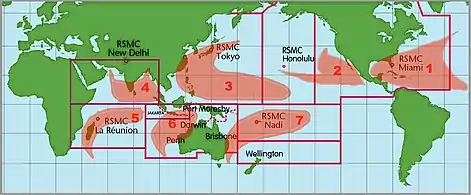
Cyclones, hurricanes or typhoons are circular storms with high winds and rains that form over water. They often cause flooding and other damage, and therefore are a threat to travellers, particularly near coastlines in the Southern United States, the Caribbean, Japan, China, Taiwan, Hong Kong, India, South Korea, the Philippines and Queensland, the Northern Territory and northern Western Australia in Australia.
This article covers only the dangers of cyclones for travellers on land. However, cyclones are also a major hazard at sea as that is where they usually develop; see our article Cruising on small craft for basic advice and consult specialist publications for more detailed advice. Cyclones can also disrupt air travel; chances of being caught in one while flying are almost nil since there are good warning systems, but flights may be cancelled or re-routed.
Understand

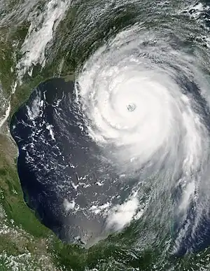
Unlike a tornado which inflicts damage along a narrow path, a cyclone can be hundreds of kilometers wide and cause various forms of damage including wind damage, flooding, and storm surge. They form around low pressure areas in tropical and subtropical oceans, around which winds accumulate due to the spherical nature of Earth. Hence, they develop a doughnut shape, with a circular band of high winds and heavy rain around a relatively calm center called the eye of the storm. They intensify while over warm water with limited atmospheric disturbances before hitting tropical or subtropical landmasses. The more optimal a cyclone's circumstances, the more likely it is to develop into a major cyclone with life-threatening winds. Since optimal circumstances are not particularly common but identifiable using modern technology, extreme cyclones are both somewhat predictable and relatively rare.
Anyone near the center of a cyclone's path first observes the consequences of a drop in barometric pressure: the arrival of darker clouds followed by rainfall and increasing wind. Following outer bands that produce heavy rainfall and strong winds, an observer would experience two intense blasts of wind and rain separated by a calm period in the eye. On the fringes of the cyclone, there is only one blast of wind and rain but it may last longer.
Meteorologically, cyclones are categorized either by intensity, using the Saffir-Simpson Wind Scale from category one to five, or by differentiating between tropical and extratropical cyclones. Tropical cyclones, which are generally the most dangerous, form over tropical waters and are in many countries known as hurricanes or typhoons. Extratropical cyclones occur in colder regions and lack the tropical cyclone's warm core and are frequently known as severe storms. When extratropical cyclones are the remnants of tropical cyclones, which they often are, they are called post-tropical cyclones.
Tropical cyclones are known by a variety of terms. They are in some regions known as cyclones, but on the east coast of Asia they are called typhoons (from Chinese tai feng, supreme wind) and in the eastern Pacific Ocean and the Atlantic Ocean they are called hurricanes. In Australia, they are called cyclones.
Being reliant on the Earth's rotation to form and rotate, tropical cyclones rarely occur near the equator, and only a minority of those that do ever make landfall. One of the most notable ones that did so was Typhoon Vamei in 2001, which battered southern Johor in Malaysia and also caused heavy rains and significant flight disruptions in the surrounding areas.
Classification
| Category | km/h | mph | wind damage |
|---|---|---|---|
| Tropical depression | ≤ 62 | ≤ 38 | negligible |
| Tropical storm | 63-118 | 39-73 | minimal |
| Category 1 | 119-153 | 74-95 | some |
| Category 2 | 154-177 | 96-110 | extensive |
| Category 3 | 178-208 | 111-129 | severe |
| Category 4 | 209-251 | 130-156 | devastating |
| Category 5 | ≥ 252 | ≥ 157 | catastrophic |
The classification systems in different regions vary, and scientists have proposed several alternatives, but the systems in current use are all similar. The table shows the Saffir-Simpson scale used by the US weather service. The wind speeds shown are for sustained winds; in any category there will be gusts of higher winds, which can cause the most damage.
Categories 3 and higher are described as "major hurricanes" in the US, while categories 4 and 5 are called "super-typhoons" in the western Pacific. Major or "super" cyclones form once every year or two in the Atlantic and more often in the Western Pacific, causing significant destruction and casualties on the ground where they make landfall.
Depending on local infrastructure and the way in which a cyclone hits an area, storms of varying category can see massive differences in impact. The size of a storm and its air pressure are also crucial factors, as broader storms such as Katrina have been more likely to hit a major city along the storm path, and storms with low pressure have brought massive amounts of heavy rain. Categories 1 and 2 can be as dangerous and damaging as major hurricanes due to non-wind factors including rainfall, or for high winds if you receive a direct hit. Therefore wind speed shouldn't be the only factor considered when trying to assess risk.
Warning systems

Areas where cyclones are common often have good warning systems; typically they show the approximate intensity and the predicted future track of any incoming storm. Forecasts are not always exact and hence frequently updated, but they are almost always good enough to provide a few days warning of major storms.
Once such a storm hits it is usually difficult or impossible to get out of the affected area; certainly neither planes nor boats can be used safely and other transport will be impeded. For most travellers, the best course is to heed weather warnings and leave before it hits. Otherwise, take shelter and wait it out, then be prepared to deal with chaos in the aftermath of the storm.
Regardless of the expected severity of the storm, obey warnings and commands from local authorities regarding what to do and whether, when, where and how to evacuate. A misjudged attempt to ride out a storm is dangerous, perhaps fatal. In these situations local residents, local government and the professional forecasters will all likely have both more experience and better information than a traveller, so take their advice!

If you are unable to evacuate, you are strongly advised to seek shelter in a sturdy building and stay indoors until it is all over. Even search and rescue may not risk themselves rescuing anyone trapped until the storm passes. In tropical or subtropical regions where cyclones can frequently form, the buildings are often designed to withstand high winds; for example they may have strong shutters which can be closed when a storm is expected. Still, stay away from windows—the cyclone may pick up pieces of gravel or other projectiles which can do real damage even when buildings are designed for the wind. In a house, get underground or cover yourself in a bathtub with sheets or blankets so that you are not blown away. In a high-rise, an interior stairwell on a lower floor may be the safest place in the building. But of course, follow the advice of local authorities above all else.
Power outages
Cyclones can cause serious power outages as objects are flying and trees are falling, taking down power lines and causing blackouts that may be quite widespread and in some cases can last for several days. Weather forecasts would usually include wind speeds especially if its threat is imminent; winds that are generally 35mph (50km/h, 14m/s) or above have the potential to take down some trees; the higher the speed and the larger the cyclone, the higher and more widespread the threat is. Even evacuation shelters are prone though the building may not be structurally damaged; a damaged power pole can cause outages within the electricity network that utilizes the pole.
In case of a power outage threat, stock up with non-perishable meals that you do not need to cool in the fridge and can last for days. Take a look at the article on camping food for suggestions. Have a cellphone with you and use it only if you need to call help; if you have a car, bring a car charger and fill up with enough fuel.
If power is off, turn off and unplug all devices that use the electricity grid as it may be damaged by a power surge when electricity comes back on (and some devices may get overheated if forgotten). Do not touch the affected power lines. It is really helpful to stay at the evacuation center (if one is set up near your neighborhood) or government service offices as they have the highest priority to have power back on; they also have some spare rations for emergencies.
Non-tropical cyclones
While tropical cyclones are the most common, there is also a special type of storm called an extratropical cyclone which can happen outside the tropical regions or during the fall and winter months; these can sometimes cause great damage when they hit areas that are not prepared for them. The main concern would be the wind that can still reach cyclone speed in addition to the rainstorm or snowstorm (blizzard).
There are also polar vortexes which form near the poles and sometimes move into populated areas. These do not have the extremely high winds of tropical cyclones — cold air lacks the energy for that — but they may still be very unpleasant with high winds and lots of snow.
See also
- Thunderstorms
- Flash floods — often the consequence of cyclones
- Tornado safety