The piton de la Fournaise (which translates to Furnace Peak in English) provides some excellent hiking opportunities on Réunion's only active volcano. The circuit of 14.5 km (9.0 mi) takes about 5 hours of walking and can be said to be one of the greatest hikes in the East African Islands.
As the trail is in the "inner zone" of Réunion National Park, the trail is on a world heritage area.
Understand
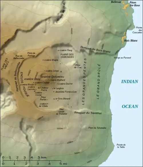
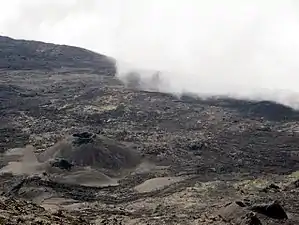
Hiking on the slopes of the Fournaise will give you the rare experience of walking in a mineral landscape formed by successive lava flows. Do not hesitate to take the paths of the Fouqué enclosure even if you have no specific destination, as you can enjoy the landscape and approach the Formica Leo. All the routes inside the enclosure are only marked by closely spaced white paint dots, so they are very easy to follow but difficult to find once you have left them. If in doubt, spot other walkers who don't look lost, and do not stray from the path under any circumstances.
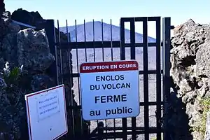
Access to the Bory crater and the crater tour route have been closed since the Dolomieu Crater collapsed in 2007.

Prepare
See Hiking in Réunion § Prepare for information on what to bring. All of that information applies to this trail.
Get in

See the article on piton de la Fournaise on information on how to get to the trail.
The only access for visitors to the inner caldera "Enclos Fouqué" with the volcanic cone and the two summit craters is to descend the steep rim of the crater near the Pas de Bellecombe car park (at 2311 m). Due to this only possible descent (approx. 100 mH, 20 minutes), the entire area can also be easily controlled and, depending on the danger situation at the volcano, can also be easily blocked by the responsible authorities. Depending on the dangerous situation on the volcano, it may or may not be possible to circumnavigate the two summit craters; the information on the signs on the descent must be observed. Access is free of charge.
Walk
The first thing you will encounter is on the "Nez de bœuf" pass (2136 m), where, after walking through lush greenery, you'll encounter a panoramic view over the "plaine des sables" (plain of sands). This plain of black sand from volcanic activity gives a hint of what is to come. A path (or more precisely, a dusty track), riddled with potholes, takes you to the "Pas de Bellecombe" (2311 m). A short walk of just a few metres from the car park takes you up to a lovely view over the "Fournaise".
It’s a breathtaking sight as you see this lunar landscape presented before your eyes. A path (which is the only way of getting to the Fournaise) goes down about 150 m in altitude in about 580 steps (we counted them!). Fortunately, there is a rail along the whole route, because the “steps” are far from being like those on normal staircases – they are from 10 cm to 40 cm in height and scramble over rock, earth, tree roots, concrete and pebbles. Nevertheless, the descent along the wall of the caldera leads you through tamarind trees and is not an all too unpleasant route.
Once you’re at the bottom, the first stop is to the "Formica Léo", a small volcano which has been inactive since 1753. From its reddish tip emerges about 20 m of ash spewed out from successive eruptions of the volcano during its active years.
The entire journey is well marked out with white markers. These white markers, about every 2 m apart, are essential in case of a sudden spell of mist – they will guide you back to the starting point. Be careful not to stray too far from them, as if you get lost there is very little chance of being rescued before the next morning, and nights up there are pretty cold!
After the Formica Léo, the signposts take you towards the peak, on hard and smooth earth, made up of old lava. A small sign marks out that it is made of “Lave Cordée” (basaltic, smooth, fluid lava, also known as “Pāhoehoe” lava). From then on, the track goes on through a more lunar-like landscape, and the long ascent begins, crossing more recently produced lava.
Getting one’s bearings is no problem, all you have to do is follow the throngs of fellow visitors. Nevertheless, drink lots and do not be deceived by the cool air at this altitude of 2200 m. The sun, even through mist, is very strong, so protect your head and use suncream sparingly all over all parts of your body exposed to the sun (including your legs). Otherwise, be prepared for a few difficult days of sunburn.
After the 2 hours of walking from the car park, you will finally arrive (about a third of the way along the route) at the summit of the Bory crater, at 2631 metres above sea level. This small crater, only 350 m in diameter, has been inactive since 1971. It’s an ideal place to take a few photos or videos to immortalise the moment.
Still following the white markers, the walk continues towards the Dolomieu crater (1km in diameter), which is still active, as the fumes will remind you. This itinerary covers the crater, and the route traverses recent lava flows. You’ll certainly feel the heat on your legs and the crunching underfoot (as if you’re walking on pieces of glass). A few signposts remind you of the danger of climbing down the rock face to get closer to the crater. The positioning of certain seismic probes around the crater’s lip will put your mind at rest slightly.
Once you are finished up on the summit, it’s just another 2½ hours of walking to return to your vehicle – without forgetting that you have to climb back up those 580 steps again!
Stay safe

See Hiking in Réunion § Stay safe for information on what to bring. All of that information applies to this trail.
When the weather is nice, the strong sunlight at high altitude and the resulting strong heating of the dark volcanic rock should be taken into account. Sufficient sun protection and enough drinking liquid should be carried with you.
It is also important to note that rain and fog are easily possible all year round from the afternoon at the latest, the result is a damp stretch of road and sometimes dangerously smooth basalt stones. In addition to the necessary sturdy shoes for the sometimes extremely sharp-edged basalt rock because it is young and a water-repellent anorak, a warm jumper should also be carried because of the rapid drop in temperature in rainy weather. Due to the usual weather deterioration in the afternoon, it is advisable to start as early as possible in the morning.
The greatest danger for hikers can be the difficult orientation in fog: The entire route runs without any special landmarks in a vegetation and soil-free ascent path on rocky volcanic terrain. Since the path is often freely chosen by visitors in the area when the weather is nice and visibility is good, there are no well-worn paths for large parts of the crater ascent on the fresh volcanic rock and therefore no clear climbing tracks. In fog with diffuse visibility and the white markers that are not always easy to see, visibility can quickly become difficult if you stray from designated trails.
Go next
- Explore the rest of Réunion National Park