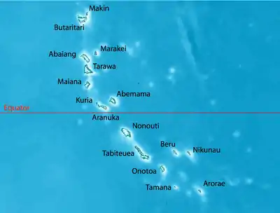
The Gilbert Islands are an island group in Kiribati.
Regions
- Abaiang - 18 km², pop.~5502 - has at least one hotel and a couple of guest houses
- Abemama - 27 km², pop.~3400
- Aranuka - 12 km², pop.~1200
- Arorae - 9 km², pop.~1300
- Beru - 18 km², pop.~2200
- Butaritari - 13 km², pop.~3300
- Kuria - 16 km², pop.~1100
- Maiana - 17 km², pop.~2000
- Marakei - 14 km², pop.~2800
- Nikunau - 19 km², pop.~2000
- Nonouti - 20 km², pop.~3200
- Onotoa - 16 km², pop.~1700
- Tabiteuea (Tabiteuea North - 26 km², pop.~3600 & Tabiteuea South - 12 km², pop.~1298)
- Tamana - 5 km², pop.~ 900 - the smallest of the Gilbert Islands (too small to construct an airstrip)
- Tarawa (Tarawa North - 15 km², pop.~5700 & Tarawa South - 16 km², pop.~40000+) - Tarawa South is the location of Kiribati's capital
Understand
The Gilbert Islands are all in the UTC+12 time zone and lie either side of the Equator. The islands are named after 18th-century British mariner Thomas Gilbert, who sailed through the islands and explored some of the islands in depth.
Get in
Get around
By plane
Air Kiribati has four small aircraft for inter-island travel. Flights travel to all Outer Islands regularly.
See
Do
Eat
Drink
Stay safe
Go next
This article is issued from Wikivoyage. The text is licensed under Creative Commons - Attribution - Sharealike. Additional terms may apply for the media files.