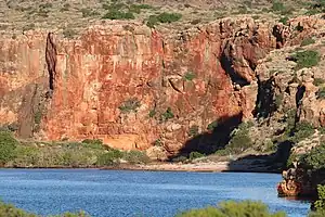
Gascoyne is one of the nine administrative regions of Western Australia. It's hot, dry and sparsely populated, with only 9277 residents in 2019 over its 135,000 sq km - half of them in Carnarvon the main town. It has a long coastline on the Indian Ocean: the Mid West region lies south and east, and Pilbara lies north and east. Tourism is its main industry, with Ningaloo Reef and Shark Bay the big draws.
Towns
Other destinations
- Ningaloo Reef is 260 km long so it flanks the entire coast. Its south end is far from shore, but north it lies close and creates coral-filled lagoons. The main visitor access is from Coral Bay, Cape Range National Park and Exmouth.
- 🌍 Bernier and Dorre Islands were used 1908-1909 to incarcerate Aboriginals thought to have venereal disease: men on Bernier, women and children on Dorre. The islands are now a nature reserve.
- 🌍 Cape Range National Park is accessed from Exmouth.
- 🌍 Kennedy Range National Park is an eroded mesa 150 km east of Carnarvon. It's arid except when spring rains bring out the wild flowers.
- 🌍 Mount Augustus National Park is a national park 500 km east of Carnarvon.
- 🌍 Red Bluff is a rugged coastline with surfing and fishing.
- 🌍 Shark Bay is a land and marine park visited from Denham or Monkey Mia.
Understand
The Aboriginal people of this region had five language groups: the Yinggarda, Baiyungu, Malgana, Thadgari and Thalanyji. There was little European interest in the area because of the poor coastline, dry interior and lack of mineral wealth, yet it saw one of their earliest footfalls when Dirk Hartog landed in 1616 on the island now named for him. He stayed long enough to affix a pewter plate inscribed with his senior crew's names, dub the continent "Eendrachtsland", then get the hell out of this unpromising spot. In 1772 the French also landed on the island and claimed all of Western Australia, but failed to let the Yinggarda and others know they were now the loyal subjects of Louis XV.
The British dominated subsequent exploration and settlement, eyeing the local pearls. In 1839 they named the Gascoyne river for Captain John Gascoyne RN, a missionary, and son of Bamber Gascoyne a Lord Commissioner of the Admiralty, the sort of fellow you wanted to keep in with. (The TV presenter Bamber Gascoigne (1935-2022) was his direct descendant.) This river only visibly flows for four months of the year, but seeps continuously underground through the sandstone and limestone aquifer. You wouldn't have to drill down very far to furnish your farm with a water supply. So although the region is not as pastoral as further south, it's suitable for sheep and cattle at low density, gnawing the scrub. By the end of the 19th century Gascoyne was parcelled into sheep-ranges, and the port of Carnarvon sprang up. That town maybe had a lucky escape, being named for the 4th Earl of Carnarvon, better known to his chums as "Twitters".
The settlers' problem was always transport, as the coast lacks natural harbours, and the sea is too shallow for large vessels to get in. The "One Mile Jetty" was built at Carnarvon to export livestock and wool. It was only in 1944 that a road connected from Perth, just a dirt track until it was sealed in the 1960s. This made possible long-distance trucking, and an outlet to market for small-scale fishing, fruit and veg growing, mining and quarrying that weren't previously viable. It also brought in tourists, lots and lots of tourists, to enjoy Gascoyne's corals, water sports and marine life.
Get in

There are flights from Perth daily by Rex Air to Shark Bay and Carnarvon, and by Qantas to Exmouth (with transfers to Coral Bay). You have to double back via Perth to fly to northern cities such as Broome.
Integrity Coaches run from Perth three times a week via Jurien Bay, Dongara, Geraldton (7 h 30 min), Carnarvon (13 hr), Coral Bay (16 hr) and Exmouth (19 hr) and onward to Port Hedland and Broome. For Shark Bay the highway drop-off is 130 km from the resort. Another weekly service runs far inland via Mount Magnet to Port Hedland. TransWA buses don't run beyond Geraldton.
By road the choice coming out of Perth is the inland Highway 1 or the coastal Highway 60 (scenic but short of filling stations); these join at Dongara. Reckon at least a day but likely two for Geraldton, and two or three for Exmouth. The buses do it quicker as they have changing shifts of drivers and don't want to see any sights along the way.
Get around
You need a car. If you didn't rent from Perth you can do so in Geraldton, Carnarvon or Exmouth. The rental offices for these are downtown but you can pick-up / drop-off at the airport if pre-booked.
Fees for national parks are standard: a day pass in 2022 is $15 for a vehicle with up to 12 occupants, pay cash or by card. Passes are also available for 5 or 14 days, one month and one year. There's no charge if you enter by bicycle or on foot, but the distances under a hot sun are formidable.
See

- Ningaloo Reef
 UNESCO World Heritage Site lies a short way offshore from Exmouth and Coral Bay.
 - OTC Dish in Carnarvon tracked the Gemini and Apollo space missions and is now a museum.
- Mount Augustus rises abruptly to 1106 m / 3629 ft from the surrounding plain. It's an "inselberg" - a chunk of hard-wearing rock from which the surrounds have eroded away. The hike to the top is five hours round trip, and best not attempted at the height of summer. The area is sacred to the Wadjari people, who call it Burringurrah for a legendary boy who was speared and turned into a rock, and their rock carvings can be viewed from the trails.
- Gassy Dash is an off-road motor rally held in March / April along the dried up bed of the Gascoyne River. The races are based at Gascoyne Junction, but for spectators Carnarvon has more amenities.
Do
- Diving: the best is on Ningaloo Reef, a short boat ride from Coral Bay or from Exmouth, which also has the Navy Pier dive.
- Snorkelling in many spots but in Shark Bay and Monkey Mia it's the main recreation, as their waters are too shallow for diving, and too warm and saline for corals.
- Surfing is mostly to the south, around Quobba, Red Bluff and Gnarlaroo, where the reef lies far offshore and the ocean breakers roar in unchecked.
Eat
- The towns have a selection of restaurants and cafes - sea-food is the main offering.
- You need to be completely self-sufficient in food and drink in the remote areas such as Gnarlaroo.
Drink

- Always have enough water inside you and within reach, but don't overhydrate.
- Most cafes and restaurants serve alcohol.
- Exmouth has a couple of microbreweries. Gin is produced on Dirk Hartog Island and may be on sale on the mainland. This climate is too hot and dry for vineyards.
Stay safe
- Traffic: watch your speed, beware driver fatigue on the endless highways, try to avoid driving at night, overtaking is best kept for designated overtaking lanes, remember Australia has a near-zero alcohol limit for drivers, and avoid dirt roads in bad weather.
- Remember sun protection and water sports safety. Don't head out into the bush without seeking local advice: there is no mobile signal if you break down.
Go next
- Pilbara is the arid region northeast as the coast turns the corner. Port Hedland and Karratha are grubby industrial ports, shipping out iron ore. Top sight is Karinji National Park inland.
- Mid West is the more pastoral region south, with Geraldton its agreeable main town.