Kevo Strict Nature Reserve (Finnish: Kevon luonnonpuisto, Northern Sámi: Geavu luonddumeahcci) in the municipality of Utsjoki, in the "head" of Finland, is famous for its vast gorge valley. In addition it is home for some very rare birds and plants.
There are two marked trails through the reserve, with limited services. There are no roads, no electricity, and mostly no mobile phone signal.
Kevo Strict Nature Reserve is almost completely surrounded by Paistunturit Wilderness Area, which has quite similar terrain and less restrictions. The most valuable nature formations are however in the strict reserve.
Understand
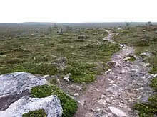
Kevo strict nature reserve was established in 1956 to protect the Kevo gorge and the surrounding fell nature. With its 712 km² area it is the largest strict nature reserve in Finland. This area has probably never been permanently inhabited but nomadic Sami have been hunting wild reindeer as indicated by many place names and several ancient trap pits. On top of the Kuivi fell there is an old sacrifice cave.
There are no wild reindeer in Lapland any more, but domesticated ones are abundant. Reindeer husbandry is an important source of income for locals and you may see reindeer anywhere within the nature reserve as well. Notice that permanent residents of Utsjoki municipality, especially when herding the reindeer, have the privilege to wander around the area much more freely than hikers.
The Kevo gorge is a rift valley, 40 km long and up to 100 m deep. It was formed by plate tectonics about 70 million years ago. There are some much smaller rift valleys elsewhere in the Kevo reserve and the Paistunturit area.
Most of the area is treeless highland, in general moor or mire. The apple-tree-like mountain birch is the only "tree" on these lands and the juniper has its own weirdly shaped forms. As elsewhere in Utsjoki the pine survives only in the most temperate locations. There are some extremely rare plant species growing in the gorge valley or its vicinity. The gorge is also a remarkable nesting site for some rare birds. Seeing a rough-legged buzzard on your way is more than probable.
The autumnal moth caterpillars caused huge damage to the mountain birch forests in the mid-1960s. An area of more than 1,300 km² became treeless (in Utsjoki, much more in Norway), part of it remaining such ever since. Some dead trunks are still visible on the ground.
The midnight sun is shining from late May to late July. Only the clouds will dim the over two months long polar day. The thermal summer usually begins no earlier than late June, and still, freezing temperatures or even snowing is possible. The trails mostly run above the treeline, so there is very little shelter against bad weather and even slight wind may make you feel cold. Lasting snow usually falls in late September.
Just about 5,000 visitors hike the Kevo trails each year, nearly all of them during the peak season in late August and early September, when mosquitoes are mostly gone and the landscape shows all its colours.
University of Turku has a subarctic research station by the lake Kevojärvi near the north-eastern corner of the reserve. All visits to the research station must be pre-appointed. At the research station there is also one of the official weather stations of the Finnish Meteorological Institute. You can check the current weather at the station on the net.
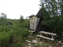
Services in the reserve and the wilderness area are limited to the trails, dry toilets (bring your own paper; there are bins for used menstrual pads) and campfire sites with firewood, benches etc., and a few open wilderness huts (one of which on the Kevo trail) and turf huts.
Get in
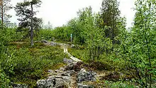
There are two entry points to the Kevo area. The distance between the entrances is about 130 km by road. If you have a car, you probably need to buy a car transfer service from some local entrepreneur. For coaches the timetables are scarce but both entries are accessible by bus. Check the timetables from Matkahuolto. Trekking from Suttesája (Finnish: Sulaoja) to Ruktajávri (Finnish: Ruktajärvi) takes about four hours, so you should reach the Ruktajávri hut before night even if you arrive by bus.
- The most popular entry point is 🌍 Sulaoja (Sámi: Suttesája) right next to the Finnish road 92, just 11 km east from the Karigasniemi village. At Sulaoja there is a parking lot and a stop on the daily bus connection between Ivalo and Karigasniemi. The 2-km nature trail around the Sulaoja spring (looking like a pond it is perhaps the biggest natural spring in Finland) is a fairly popular destination, having around 20,000 visitors each year. The trail towards the nature reserve departs from this nature trail.
- The other entry point is 🌍 Kenesjärvi (Sámi: Ganešjávri) right next to Highway E75 about 24 km south from the Utsjoki parish village. There is a parking lot and a bus stop with daily coach connection (Rovaniemi–Nuorgam/Tana Bru/Vadsø; check whether the cross-border service runs). For most Kevo trekkers Kenesjärvi is the exit point as the Kevo trail is much, much easier to hike from Sulaoja to Kenesjärvi than vice versa. Using Kenesjärvi as a starting point is recommended only if there is significant north wind on the area. If you start from Kenesjärvi your hike will start with a 470-step staircase.
Fees and permits
There are no entry, camping or hiking fees.
Kevo is a strict nature reserve so the usual right to access does not apply. Hikers must stay on marked trails. Overnight stays are allowed only at the campfire sites. Making a fire is allowed only on dedicated fireplaces and is, of course, forbidden if there is a wildfire warning in effect. The fireplaces are equipped with firewood as you cannot collect any from the surrounding nature. Using a camping stove is always allowed, but be careful.
Dogs are allowed but they must be on a leash all the time.
Restrictions:
- No entry to the gorge area from April 1st to June 14th.
- Hiking is permitted on the marked trails in the gorge area from June 15th to October 15th and in the fell area from May 1st to October 15th.
- Skiing is permitted everywhere in the gorge area from October 16th to March 31st and in the fell area from October 16th to April 30th.
- In the Kevo Strict Nature Reserve hunting and fishing are completely forbidden. So is collecting plants and invertebrates. Picking edible mushrooms and berries is allowed only for permanent residents of the Utsjoki municipality, not for visitors.
The route from Sulaoja to Ruktajärvi is in the Paistunturit Wilderness Area where the right to access does apply. The border of the strict nature reserve is marked with green-white signs and red poles. From Kenesjärvi the restricted area begins after a 2-km walk from the parking lot and is similarly marked.
Get around
Before you go, contact Finnish Forest Administration's Customer Service at Siida and ask about the current conditions on the trail (☏ +358 20-639-7740, siida@metsa.fi).
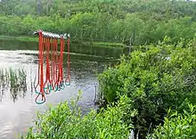
During the summer season hiking by foot is the only means to get around. The terrain is rough at many places. You should probably have sturdy footwear. Remember to pack swimming shoes for fording as there are no bridges (some maps show a bridge over Njaggaljohka but it does not exist). At Luopmošjávrrit, Roajasjávri and Bálddotjávrrit there are duckboards over rivulets a few metres wide.
Most of the steepest climbs and descents are equipped with wooden staircases. Duckboards take you over the large mire close to lake Bálddotjávri. These duckboards have been renovated in 2019. There are grip wires for help at the fords. The deepest ford is the northernmost one near Beahcelávojávrrit.
In winter you need proper cross-country skis, suitable for both loose and hard snow, the former at least in midwinter. There are no marked or maintained winter tracks. During the winter daylight (or more accurately twilight) is limited to a few hours and temperatures as low as −30 °C (−22 °F) are fairly common, lowest recorded temperatures are below −45°C (−50°F).
Notes
- Ascends from Fiellu valley and from the gorge towards Gámajotnsuohpašája are at least demanding.
- From Fiellu towards Bodosroadjá the trail goes 3 km uphill, the first 100 metres up within approximately the same horizontal distance. Take all the time you need.
- At Roajasjávri the descent to the gorge is very steep and the path is narrow. The stairs eventually appear for the last 20 m vertical drop when you are already tired. The soil is loose. Be careful.
- At Tapiola Goahti there is a fixed rope to help you climb the rock.
- From the Kenesjärvi direction climbing up from the Njaggaljávri and from the Fiellu valley are the hardest parts. At Njaggaljávri there is a staircase with more than just some hundreds of steps to climb, and after those the hill continues upwards for several kilometres.
Routes
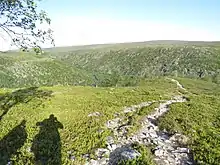
- The Kevo trail (Finnish: Kevon reitti, Sámi: Geavu bálggis) is 63 km long and runs through the nature reserve from Sulaoja in the south-west to Kenesjärvi in the north-east. The terrain is occasionally very challenging and the trail takes 3–5 days to complete. The trail descends down to the bottom of the gorge and climbs up to the fells several times, and these climbs are steep. Rivers and creeks must be crossed by wading, some by stepping from stone to stone. You need to ford across river Fiellu once and river Kevo thrice. Both rivers are shallow but the current is strong. If the water level is high, it is better to turn back. On the map a ford is kahlaamo in Finnish or gála in Sámi. See the Kevo route description.
- The Kuivi trail (Finnish: Kuivin reitti, Sámi: Guivvi bálggis) is a 87-km circular route, which starts and ends at Sulaoja. The trail takes 4–7 days to complete. The trail follows Kevo trail to the Ruktajávri hut but then heads north towards the Kuivi fell and enters the strict nature reserve near the fell. The climb to the fell top is hard. The trail meets Kevo trail again near the Fiellu waterfall and comes back about 9 km following the edge of the Kevo gorge. You need to ford several small rivers and creeks. There are open wilderness huts at Ruktajärvi, Kuivi, Akukammi, Njaugoaivi, and Ruktajärvi (again). See the Kuivi route description.
Map
This is very remote area. For safety reasons a printed map is a must.
The whole area is shown in Kevo Paistunturit map (1:50,000, partly 1:25,000) by Calazo and the Utsjoki-Kevo-Paistunturit map (1:50,000). Both maps cost about €20. You can buy the maps from the web, bookstores, most grocery stores in Northern Lapland, or from the Siida Visitor Centre in Inari village. The maps have explanations in English.
A GPS might be helpful but the signal is usually weak or absent. Mobile phone location is of use in the beginning and end of the trail. Missing the mobile network elsewhere runs the phone out of battery within hours. Just turn it off (or use flight mode) until you need it. Also the GPS of the phone uses a lot of power when enabled.
See
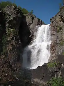
- 🌍 Sulaoja spring (Sámi: Suttesgáldu, Finnish: Sulaojan lähde) and 🌍 Luomusjärvet lakes (Sámi: Luopmošjávrrit) are on the trail but located in the Paistunturit Wilderness Area. The lake Luomusjärvi is divided into two parts by a narrow but high esker. The trail follows the ridge of the esker. Enjoy the views.
- 🌍 The Kevo Wall. (Finnish: Kevonseinä) This is the iconic view that everyone has come here to see. The South-West end of the gorge is a sudden deep vertical drop, and the way it just appears in front of you is amazing. Remember to take a look to a long and narrow waterfall on the right. The Kevo Wall is over 20 km from the Sulaoja parking lot and, even though the trail is relatively easy to walk this far, this is not a day trip destination. You need to stay overnight somewhere on the trail.
- 🌍 Fiellu waterfall. (Finnish: Fiellun putous, Sámi: Fiellugordži) One of the tallest waterfalls in Finland. Down in the gorge about 5 km from the Kevo wall. The trail from Kevo Wall to the waterfall is much more challenging than the one so far, as the path becomes more rocky and there are deep ravines on the way. The surrounding kettle shaped valley has surprisingly lush vegetation because of its warm microclimate. Notice how the pine trees survive in this valley but not elsewhere nearby. When you ascend to the fell again, remember to look back to the impressive cross-shaped valley system.
- 🌍 Kuivi fell. (Finnish: Kuivi, Sámi: Guivi) The highest peak of the Paistunturi massif raises to over 640 m a.sl. The fell is located by the Kuivi trail over 40 km from the Sulaoja parking lot. Leave your backpack at the Kuivi wilderness hut to climb the last kilometres to the fell top with much lighter equipment.
- 🌍 View to Njaggaleapme lakes. Although not as famous as the Kevo Wall, the panorama to these narrow lakes down in the canyon is awesome. The staircase down to the canyon is steep and has several hundreds of steps. The lake itself has a beautiful sand beach right next to the camping site. Try swimming in the freezing cold water.
- 🌍 Trap pit. This trap pit, hundreds of years old, isn't a very impressive sight any more but being located right next to the trail it is perhaps the most visible reminder of the old wild reindeer hunting culture which died out in the 19th century. This kind of pits were maintained and used for centuries until the hunting turned into herding and they became obsolete. There are many more reminders of the hunting culture inside the reserve varying from various Sami language place names to this kind of traps. Another easy-to-see trap pit is at the Geavvugeašláttu camping site. In the surrounding pine forest traces of a 1985 forest fire are still easy to see.
Do
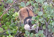
Enjoy the nature and awesome views. Try to spot rare birds, insects, mammals or plants.
Buy
The nearest grocery stores are in the villages Karigasniemi, Kaamanen and Utsjoki. There are probably no ATMs in these villages; cards should work in the shops and you might be able to get cash when paying your purchases.
Kevo Strict Nature Reserve t-shirts and patches as well as Arctic fox plush toys are for sale at Siida Shop in Inari village.
Eat
The nearest restaurants are in Karigasniemi, the Muotkan Ruoktu holiday village, and the villages Kaamanen and Utsjoki.
For cooking on the trail you need to carry not only the food but also your own camping stove, fuel and matches. You can also use campfire sites. There is firewood but you need to chop them first (this is to limit how much firewood people use). Every camping site has waste bins but you are really expected to carry all your waste out. Follow the leave-no-trace principles.
Drink
In practice all running waters are potable, but close to the camping sites it might be a good idea to boil it anyway. In summer 2017 there was diarrhoea epidemic among the Kevo hikers, probably caused by a carrion somewhere upstream a creek.
Sleep
Before or after
- 🌍 Kalastajan majatalo ("Fisherman’s Inn"), Ylätenontie 32 (10 km from Sulaoja), ☏ +358 40 484 8171, toimisto@hansabar.fi. Accommodation and restaurant. double room €70/night; cabin (no amenities; June 1–July 31) €50/night; apartments from €85/night.
- 🌍 Kaktsavarri, Karigasniementie 4195 (17 km from Sulaoja), ☏ +358 400 642 777, kaktsavarri@gmail.com. March–September. Cabins. Sauna.
- 🌍 Muotkan Ruoktu, Karigasniementie 2281 (33 km from Sulaoja), ☏ +358 400 860 668, muotkanruoktun@gmail.com. March–September. Cabins, caravans and camping. Restaurant. Sauna. Trails into the Muotkatunturit Wilderness Area.
- 🌍 Kaamasen Kievari, Kaamasentie 2855 (60 km from Sulaoja), ☏ +358 16 672-713, info@kaamasenkievari.fi. Apartments and cabins. Restaurant and a grocery store. Fuel.
- 🌍 Kenestupa, Utsjoentie 2735 (500 meters from Kenesjärvi), ☏ +358 400 344 545, kenestupa@saukko.fi. June to mid-October. Cabins by an old postal route just 500 meters from the Kenesjärvi entrance of the trail. Car transfer service.
- 🌍 Kevonranta, Utsjoentie 1720 (9.6 km from Kenesjärvi), ☏ +358 40 828 3538, kevonranta@gmail.com. Cabins.
On the trail
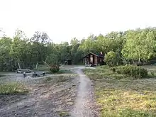
Own tent is a must. Do not attempt to hike here without suitable capability to sleep outdoors. Camping is allowed only on official camping sites, there are 14 of them on the Kevo route and 9 on the Kuivi route. All camping sites have a dry toilet, garbage bin, fireplace, table with benches, some firewood, and pallets to be used under the tent if you wish. No other service, and no personnel. Take your waste out from the reserve. All camping sites are located next to some kind of water resource. Don't forget to bring your own toilet paper!
Nights are cold. Even in July the temperatures might get below +10 °C (50 °F) at night.
The 🌍 Ruktajávri open wilderness hut in Paistunturit Wilderness Area is the only hut for hikers on the Kevo trail and, given its location, often rather crowded. On the Kuivi trail there are three more open wilderness huts 🌍 Njávgoaivi hut, 🌍 Akukammi hut, and 🌍 Kuivi hut but never rely that you can use a hut. Camping is allowed in the vicinity of all huts. If the hut becomes crowded the lastcomers have undisputable right to stay.
The lapp pole huts at 🌍 Suohppášája and 🌍 Gamajotnsuohppášája as well as the 🌍 Fiellu turf hut are meant to provide shelter in case of bad weather and a warm, dry place for cooking and drying your equipment. They are not intended for staying overnight. You can heat up the stove in these huts even if there is a wildfire warning outside. A turf hut at Tapiola Goahti burned down completely in 2015, and seems to be removed from the maps.
The 🌍 Madjoki open wilderness hut is far away from any trail and therefore it may be visited only in winter.
The Finnish Forest Administration has a few more huts inside the reserve for its own technical needs. One of these is erroneously marked to some maps as a lonely toilet(?!) in the southern end of Bajit Njaggalluoppal. It is not a toilet nor accessible to visitors.
Stay safe
Kevo is ranked as a very demanding trail. The terrain gives challenge even for people in good physical condition. Do not go without sufficient experience. Even though the trail is visible on the ground, this is so remote a place that one should carry a printed map and a mechanical compass for safety reasons. Make sure you know how to use them. On the Luomusjärvi esker and nearby lake Balddotjávri there are other trails intersecting the Kevo trail. Make sure you follow the one with orange markers.
Most part of the fell area and the whole gorge are without mobile phone signal. Do not hike alone: in case of emergency you probably can't call for help from where you are.
Do not forget first aid equipment. In a possible emergency situation it will take several hours before you end up in the hospital even if you have signal nearby and will be evacuated with a helicopter.
In case you visit the area in June or July, prepare yourself for a vast number of mosquitoes and blackflies by repellent and suitable clothing.
Tell about your plans before you leave, and give a hard deadline when emergency services should be called unless you have announced your return or told about being belated. Remember again there is no mobile phone network around.
Always put your name on the guestbooks in the huts and also tell there where you are heading next. If you disappear, the guestbooks will provide information to the rescuers. Also write down to the guestbook if there was something wrong in the previous hut or on your way on the route so other hikers can prepare. Don't forget to leave your greetings.
Go next
- Other hiking trails in Utsjoki
- Muotkatunturit Wilderness Area – wilderness across the road from Sulaoja
- Lemmenjoki National Park – vast forest backcountry behind Muotkatunturit
- Urho Kekkonen National Park – one of the most popular national parks in Finland
- Varangerhalvøya National Park – truly Arctic national park in Norway.