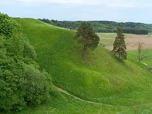
Dzūkija or Dainava is a region in south-eastern Lithuania.
Cities
Other destinations
- 🌍 Dzūkija National Park — the biggest forest (Dainavos) and swamp (Čepkelių) in the country, and some old unique villages in the middle of the forests
- 🌍 Medininkai Castle — well preserved historic castle ~35 km. from Vilnius
- 🌍 Center of Europe — (near Purnuskes, 25 km north of Vilnius) Purnuskes claim to fame is that in 1989 the National Institute of Geography, of France, calculated the centre of Europe to be just outside the village. A stone memorial was erected on the calculated spot. A subsequent revision, after it was realised that Malta had been omitted from the calculation, changed the location ... by about 100 metres. A brand new memorial pillar was erected in 2004 to mark Lithuania's membership of the EU.
- 🌍 — Former Lithuanian capital at the bank of the river Neris and now a well-preserved archaeological site that is inscribed on the
 UNESCO World Heritage Site.
 - 🌍 Aukštojas Hill — (near Medininkai village, a few km from the border with Belarus) At 293.84 m, Aukštojas is the highest point in Lithuania. Juozapinė Hill, about 500 m away is the third highest point in the country.
- Two points on the Struve Geodetic Arc
Understand

Dzūkija is a cultural region in south-eastern Lithuania. Most of the region is sparsely populated and covered by forests, stretching north-east from the border with the Polish region of Podlaskie. The northern part of the region, however, is the cradle of Lithuanian statehood and includes the current capital Vilnius and two medieval capitals - Kernavė and Trakai. Two of Lithuania's five national parks can be found here as well as three of the country's four UNESCO World Heritage Sites. Eight regional parks are also established in the region and serve to protect both the natural environment and cultural heritage.
Talk
As in the rest of Lithuania, the official language is Lithuanian. However, in some parts of the region Polish is widely used due to the significant number of ethnic Poles living in the area.
Get in
Get around
See
- 🌍 "Meschkanzi" (Meškonys). One of the points of the world heritage listed Struve Geodetic Arc. There's a small parking pocket next to the road and from there a path goes for 200 m slightly uphill through the meadow to the marker.