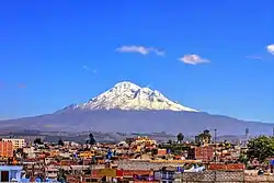
Chimborazo is an inactive volcano and the highest mountain in Ecuador at just about 6,263 m (20,548 ft). It is a popular hiking and mountain climbing location.
Understand

Chimborazo's peak is Earth's further point from its center, kilometers farther than the Everest's. This is because the Earth is not a perfect sphere but an oblate spheroid, i.e. it is a little bit "thicker" near the equator.
Under clear conditions, the summit of Chimborazo can be seen from Guayaquil, nearly 140 km (87 mi) away. The nearest cities are Riobamba (~30 km to the southeast), Ambato (~30 km to the northeast) and Guaranda (~25 km to the southwest). Chimborazo is surrounded by the Reserva de Producción Faunistica Chimborazo, which forms a protected ecosystem to preserve the habitat for the Andes native vicuñas (same family as llamas - nicknamed the "Andes damsels"), llamas and alpacas.
Get in
To climb to the top of Chimborazo you will need a guide and equipment. There are several tourist agencies in Riobamba where you can get both of these services for a price of about $450 per person for a group of two or more. Climbing solo with a guide will cost closer to $600. Climbs leave at about 00:00 (midnight) in order to summit at sunrise and make the descent by late morning. A round trip should take about 9-10 hr.
Even if you're not a mountain climber or on a budget, you can still hike Chimborazo: buy a ticket from Riobamba's bus station to Guaranda (1 hr, $2.5, every 30 min). Ask the bus driver to drop you off at the Chimborazo entrance (free but you need to register) at 4300 m (14100 ft). Then either hike till the first refuge (3 hr if you follow the road, 1:30 hr if you go straight) at 4800 m (15750 ft) or share a taxi ($15). From there you can hike to the second refuge (Whymper at 5000 m, 16400 ft) and finally to the (very) small lake at 5100 m (16700 ft). You are not allowed to go further without a guide. There are very good chances to see vicuñas between the entrance and the first refuge, so it can be a good idea to go back by foot.) Some agencies offer mountain biking down the first refuge. You may also combine the above with an alternative trail, going from the first refuge to community tourism Casa Condor, via Templo Machay and the árbol solitario Quichuar (9 km, 6 hr - as written on sign close to for refuge). Casa Condor is close to the road, you may take your bus from there.
See
- Glaciers – The top of Chimborazo is completely covered by glaciers, with some north-eastern glacier arms flowing down to 4,600 m.