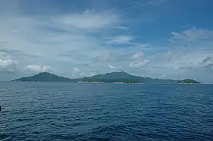
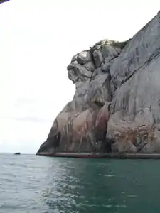
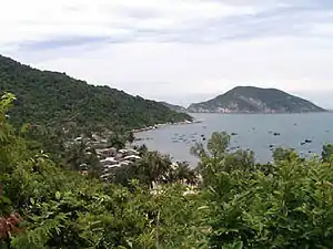
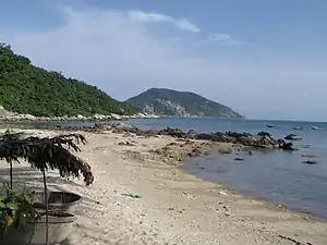
The Cham Islands (Cù lao Chàm) are off the Central Coast of Vietnam. Approximately 9 nautical miles offshore and to the east of Cua Dai Beach, Hoi An, Quang Nam Province. This covers an area of 235 km2 which includes eight islands and surrounding waters. There are eight islands in the Cham Islands: the largest and only inhabited island Hon Lao (covering an area of 1,317 hectares with a hilltop elevation of 517 m), Hon Cu, Hon Kho, Hon La, Hon Dai, Hon Lo and Hon Tai.
Understand

In May 2009 the UNESCO Biosphere Reserve Cu Lao Cham - Hoi An was created. It includes Hoi An Old Town, most of metro Hoi An, the river inlet, the ocean between Hoi An and the Cham Islands, and the islands.
However, since this UNESCO Biosphere Reserve was created, domestic mass tourism has led to increased destruction of the islands, its communities, and the environment.
UNESCO Biosphere Reserve status is supposed to ensure preservation and with it an improvement in the sustainability of the environment. As soon as UNESCO status was awarded in 2009, mass tourism by mostly domestic Hanoi tourists, exploded and resulted in the islands being fished out in summer 2010 due to the massive increase in visitors. In 2011 the situation got worse.
One of the most blatant examples of destruction within a UNESCO Biosphere Reserve is the "birds nest" business in CLC. Not a single local islander is employed in this business. The numbers are staggering: birds nests sell for around US$4,000 per kg. All this is happening inside a United Nations sanctioned site.
History
Humans have inhabited Cu Lao Cham for at least 2,500 years. These islands were sacred in the eyes of the Cham people.
The Cham are a Malayo-Polynesian people who had settled in Sa Huynh, Central Vietnam, around 200 BCE. The Champa Kingdom was created in Hue region around 200 CE and lasted until 1835.
The commercial capital of the Champa Kingdom was Hoi An from which during 7th-10th centuries the Champas controlled the spice trade between the Spice Islands in Indonesia and China, India, and the Persian Gulf states. The Champas, who owned vessels very similar to those seen in Hoi An waters today, ruled the spice trade routes long before the Chinese junks or Portuguese vessels entered these waters.
Hoi An was a major trading port, on a par with Macau and Malacca, from the 16th-18th century. Early influences were Chinese and Indian and by the 10th century some Champa had converted to Islam through Arab maritime influences.
The leeward (from NE monsoons) anchorage in the capital village of Bai Lang makes the bay ideal for shelter of larger vessels. The depth is approximately 15 m in the channel between Hoi An and the Cham Islands and in Bai Lang Bay averages 10 m. Larger cargo vessels unable to enter the Hoi An River inlet would anchor off Bai Lang and lighters would then carry cargo ashore to warehouses in Hoi An.
Chinese, Japanese, and other northern merchants would sail their vessels down from the north on a "broad reach" during autumn and winter (riding on storms blowing NE monsoons) and wait for the trade winds to turn during spring and summer into a more gentle southerly breeze which would again send them on a "broach reach" back up north (and sometimes into seasonal typhoons!) While they waited for winds to change some foreign merchants lived and did business in Hoi An.
It is recorded on a 700 CE Chinese chart that vessels sailing the "Nanhai Trade Route" used a fresh water source at Bai Lang. Nanhai means "south sea"; these ships were based in ports on the Pearl River, in Guangdong, China.


Landscape
Cham Island topography is mostly mountainous, without rivers, except for the biggest island of Hon Lao, where there are some rocky fresh water streams with natural forests. The highest point is at 517 m on the top of Hon Lao, other islands peaks are lower with elevations from 70–200 m.
Flora and fauna
Hon Lao Island and many of the other islands of the archipelago are extensively forested. On the east side of Hon Lao and some other rocky islands such as Hon Co, bird's nests (for making "bird's nest soup") are harvested and traded.
A wonderful natural product from Cu Lao Cham is the six leaf tea which is grown and harvested. It is reputed to be a detoxifier.
Marine ecology
According to surveys, there are 135 species in 35 genera of corals found around Cu Lao Cham. Six species in the Sea of Vietnam were first recognised here. There are 202 species in 85 genera and 36 families of fish; and 4 species of lobsters and 84 species of mollusks identified.
The Vietnamese Government, together with the Danish Government, funded the Cu Lao Cham Marine Park Administration which created Vietnam's second marine park. The Cu Lao Cham Marine Protected Area (MPA) includes eight islands and 5,175 ha of water surface with 165 ha of coral reef, 500 ha of seaweed and sea grass beds, which provide habitat for various valuable fish species.
The waters around the Cham Islands are an important fishery. Several species of high economic value, such as lobsters, groupers, snappers, craps, shrimps, and clams, occur in the area. The islands' coral reefs provide shelter, nurseries, and food for marine creatures.
Weather
In February 2012 at least 7 people drowned in a boat accident at the river inlet. Tourism to CLC is only possible with safe reliable transport provided by boats. This is not being provided. Pier facilities are very poor at the Bien Phong river inlet and the two villages on the islands.
Even during "calm" season there are days of serious squalls when speedboats are unable to safely operate. The islands are 10 nautical miles offshore and by far the most hazardous part of the journey is at the river mouth which has an average depth of only 0.9 m in the spring.
The climate is influenced by tropical monsoons. If compared to the mainland, the island are cooler. The average temperature differential between the hottest and the coldest months is 6.7 °C. The islands are more humid than in the mainland. The average humidity is 85.7% and the lowest humidity is 81%. The average wind speed is higher than that in the mainland at 3.6–4 m/s. Typhoons and heavy storms mostly appear in the islands during September–October.
Dangerous floods can occur throughout Hoi An area from September–December during periods of heavy rains, strong onshore NE winds (prevailing conditions during September–December) and during 1–2 days around lunar calendar days 1 and 14 of each month. The river has nowhere to go as the ocean forces its way inland, and average water levels are also rising each year.
A changing climate has resulted in rising sea levels and a serious loss of beaches. Since 2005 approximately 30 metres have eroded on Cua Dai Beach. There may be no future for resorts and hotels along the beach. One good typhoon and the isthmus which extends from the inlet towards Da Nang will easily be breached. In 2011 the "calm" weather season had been reduced to mid-June to mid-August, compared to at least 6 months less than 5 years ago.
Get in
Because of the extreme shallow water conditions at the river inlet to the ocean, which has an average depth of only 900 mm, breaking swells from September–December (during NE monsoon season) makes the Cham Islands almost inaccessible; during January–May only sometimes accessible; June–August almost always accessible. Weather conditions also change during the day: mornings are calmer, with stronger winds and waves after about 13:00.
Summertime squalls are frequent in late afternoons (look towards Laos and see if dark clouds are forming); beware of being caught on an unsafe boat in a dangerous squall. In Vietnam few boats operate to international standards or are designed for rough waters.
Most days about 07:30, weather permitting (normally not during September–December), a light blue coloured 20 m long, wooden, top heavy, flat bottomed ferry leaves Hoi An public pier with all manner of cargo aboard bound for the Cham Islands. Foreign tourists pay an inflated price (compared to local prices of 20,000 dong) of at least 100,000 dong one-way.
If you are at the old ferry stop at Bien Phong (Border Patrol) at the entrance to the river inlet to ocean, you will sometimes be asked to show your passport and valid visa. For some reason this does not happen with speedboats.
The old ferry goes to the largest village, "Bai Lang", on the largest island, "Hon Lao", and returns to Hoi An departing about 15:00. Journey takes about 2 hours.
There are daily tours to the Cham Islands operated by some travel companies, which include minibus transfer from Hoi An or Da Nang. Departure from Cua Dai beach dock at Bien Phong (Border Patrol), which takes 30 minutes by speed boat and 1.25 hr by wooden boat. Generally, they only operate May–August because the speedboats cannot operate in rough weather.
- Cham Island Tour, ☏ +84 510 8505605. Pick up at hotel at 07:00, transfer to Cua Dai beach harbour by an air-con bus. Cruises to the Cham Islands board at 08:00, travelling by wooden boat for 1¼ hours or by speed boat for 30 minutes. On arrival, there are visits to Hai Tang Pagoda, the boat shelter, a local market at Bai Lang, then cruise to Bai Chong for swimming and snorkelling to see the coral reef before having lunch at a local restaurant on the island. Relax for a while after lunch and get ready for cruising back to Cua Dai Beach harbour. Departure is at 15:00 and transfer back to your hotels. Wooden boat USD27, speedboat USD89.
Fees and permits
Generally for day trippers travelling with a dive operator, a snorkelling permit is issued by the Cu Lao Cham MPA (for a fee of 30,000 dong) for each tourist. This is probably the easiest way for a tourist to travel there.
Get around
Most tourists travel on a boat with a dive operator or ferry company. Travel between the two villages and the beaches between them is best done on foot.
See
- Island forests are beautiful and host a large wild monkey population. Natural forest covers about 25% of the island.
- Hiking is only allowed on the road between the two villages.
Do
Snorkelling & diving
Cham Islands Marine Park Administration (MPA) has a number of protected areas were only snorkelling is allowed. Snorkelling permits are required for snorkelling in these areas (income goes to MPA to support marine protection).
The best season for snorkelling is during the calmer summer months of June through the end of August when ocean sediment is settled and sunlight is strongest.
There are more jelly fish, so wear a T-shirt in the water for protection.
Normally April–June is also reasonable snorkelling, if one can get to the islands as the weather can be rough sometimes.
Autumn and winter (starting 1 September–April) is normally rough weather with monsoon storms lashing the coast. Tourists rarely can go to the islands or go snorkelling.
- Cham Island Diving, 88 Nguyen Thai Hoc str, Hoi An (in the old city), ☏ +84 510 3910782. 07:45-21:30. PADI dive centre offering full range of services on the island from Hoi An: PADI courses, scuba diving and snorkelling, simple excursions and private cruise by wooden boat and speedboat, camping under the stars and home stay in authentic fisher village. USD28-75.
Buy
Eat
The larger village, Bai Lang, has a few restaurants. The smaller village, Bai Huong, only has one or two small coffee shops.
Drink
Sleep
| Note: Chinese, Hong Kong and Macau passport holders are not permitted to stay overnight on the islands. |
- Homestay Bai Huong, 45 Le Loi, Hoi An (Old town), ☏ +84 120 2378530. Homestay Bai Huong offers sustainable tours to the fisher village in Bai Huong. Offer a 2 day tour, with snorkelling trip, trekking, and cultural exchange with the home stay families and the local people. 440,000 dong.
- Karma Waters, 213 Nguyen Duy Hieu, Hoi An (Centre, opposite An Phu Hotel), ☏ +84 510 3927632. Home stays inside private village homes at Bai Huong village. Daily rates USD120/person. All vegetarian meals included and return boat. Cham Island Day tour USD90. 08:00 departure. Snorkelling, swimming, vegetarian lunch. Also traditional Vietnamese sailing vessel, 10.5-m Ghe Nang, for cruises and sail training all year around the Cham Islands.