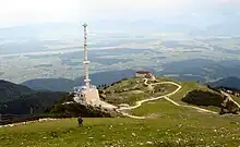
Cerklje na Gorenjskem is in Central Slovenia, a rural area consisting of several villages. It covers both mountainous as well as flat areas below the southern end of the Kamnik-Savinja Alps. The mountain Krvavec also lies within the municipality. You may see it from far away due to its radio tower, sporty people love to hike, ski and bike around it.
Touristic information can be found at the Cerklje touristic association (Zavod za turizm Cerklje), Petrovčeva hiša (Pr Petrovc), Krvavška 1b, ☏ +386 4 251 67 27..
Understand
First Cerklje na Gorenjskem was attested in historical sources in 1147 as Sancta Maria (and as Ecclesia sancte Marie in Cirkelach in 1239 and Zirchlach in 1271). The name Cerklje is derived from the plural demonym *Cerkъvľane (< *cerьky 'church'), meaning 'people living on church territory' or 'residents of the village with the church'.[4] In the distant past, the settlement was also known as Trnovlje in Slovene (attested as in Tirnovlach in 1239), from the church dedicated to Our Lady of the Thorn (Slovene: Marija v Trnju).[4][5] The name of the settlement was changed from Cerklje to Cerklje na Gorenjskem in 1952.[6] In the past the German name was Zirklach.[2]
Get in
Get around
See
Do

- Kravaec (ski, mountain bike or hike) (by car via Cerkelj na Gorenjskem, Dvorje and thereafter Grad), ☏ +386 4 25 25 911. Home to a much liked ski resort, as of 2016 also a bike park and offering great places to hike.
Buy
Eat
- Brunarica Kekec, Ambrož pod Krvavcem 31, info@krvavec.org.
Drink
Sleep
- Dom na Krvavcu, Ambrož pod Krvavcem 31, info@krvavec.org. apartments
Connect
Go next
- Kranj has a fine old city centre.
- Kamnik is a lovely medieval town, now sleepy in its old age.
- Škofja Loka has an attractive medieval centre.
- Triglav National Park adjoins Bled and Bohinj.
- Ljubljana is Slovenia's lively picturesque capital.