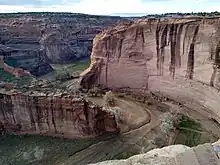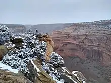
Canyon de Chelly National Monument (duh-SHAY) is a national monument within the Navajo Nation in Northern Arizona.
The park preserves ruins of the indigenous tribes that lived in the area, from the Ancestral Puebloans (formerly known as Anasazi) to the Navajo, and reflects one of the longest continuously inhabited landscapes of North America.
Understand
Canyon de Chelly is unique among National Park Service (NPS) units, as it is comprised entirely of Navajo Tribal Trust Land that remains home to the canyon community. NPS works in partnership with the Navajo Nation to manage park resources and sustain the living Navajo community.
History
Canyon de Chelly has been occupied for millennia. In several places petroglyphs (rock carvings) and cliff houses of the Anasazi can be seen. The Navajo were living in the canyon when the Spanish arrived in the 1700s. The next century was marked by repeated conflicts with the Spanish and other Indian tribes, and later with the U.S. Finally, in 1864, Kit Carson led a campaign to remove the Navajo to Fort Sumner. Cold and hungry, most surrendered and began the Long Walk to Fort Sumner. After four years of hardship, the Navajo signed a treaty with the U.S., which established the reservation. A few dozen families live in the canyon at least part of the year, farming and herding.
Landscape

The national monument comprises three canyons. Canyon del Muerto and Monument Canyon join to form Canyon de Chelly. At its mouth, the canyon floor is broad and flat. There is sufficient water for patches of lush vegetation. The canyon walls rise steeply for about a thousand feet.
Flora and fauna
Climate
The temperature can reach 100 ℉ (37 ℃) on the canyon floor in the summer. Winter temperatures range from lows around 20 ℉ (-7℃) to highs of 40 ℉ or 60 ℉ (4 ℃ to 15 ℃). With altitudes ranging from 5,500 feet (1,524 m) on the canyon floor to 7,000 feet (2,134 m) on the rim, it can be cold here in the spring and fall even when it is hot at lower altitudes. The weather can be changeable, with a little snow in the winter, and sudden thunderstorms in the summer and fall.
| Canyon de Chelly National Monument | ||||||||||||||||||||||||||||||||||||||||||||||||||||||||||||
|---|---|---|---|---|---|---|---|---|---|---|---|---|---|---|---|---|---|---|---|---|---|---|---|---|---|---|---|---|---|---|---|---|---|---|---|---|---|---|---|---|---|---|---|---|---|---|---|---|---|---|---|---|---|---|---|---|---|---|---|---|
| Climate chart (explanation) | ||||||||||||||||||||||||||||||||||||||||||||||||||||||||||||
| ||||||||||||||||||||||||||||||||||||||||||||||||||||||||||||
| ||||||||||||||||||||||||||||||||||||||||||||||||||||||||||||
Visitor information
- 🌍 Visitor Center. Pick up a park map at the Visitor Center which features a park store, orientation video and activity schedule. Visitor Center and parking lot gates open daily from 8 AM to 5 PM. Closed on Thanksgiving, Christmas and New Year's Day.
Get in
By car
Canyon de Chelly National Monument is off US Route 191, about 1 hour and 15 minutes north of the town of Chambers at the intersection of US-191 and Interstate 40. Chambers is about 2 hours east of Flagstaff (with Petrified Forest National Park en route) and 2 hours and 40 minutes west of Albuquerque on I-40.
If coming from the northeast (e.g. Farmington, New Mexico), it may work nicely to stop at the overlooks on the north rim on your way in rather than driving to the Visitor Center (at the west of the park) and then backtracking.
By train
The closest city with an Amtrak station is Gallup, New Mexico, about 45 minutes east of Chambers on Interstate 40. It is served by the Southwest Chief Los Angeles–Chicago route.
By air
Canyon de Chelly National Monument is very far from any major airport. Your best bet would probably be Albuquerque International Sunport (ABQ IATA).
Fees and permits
There are no fees to enter the park. To drive on the canyon bottom, a 4-wheel drive vehicle, a Park Service permit and an authorized Navajo guide are required. The fee is $15 an hour for 1 vehicle, $5 an hour for each additional vehicle with a 5-vehicle limit per guide. Hiking within the canyon requires a Park Service permit and an authorized Navajo guide, except along the 2½-mile (4-km) White House Ruins Trail. One guide may take up to 15 people for $15 per hour.
Get around
See
.JPG.webp)
- The 🌍 White House Ruins Trail leads to the only Anasazi ruin that can be visited without a guide.
- Scenic overlooks along the North and South Rim Drives provide dramatic views of the canyon below, with its sheer walls.
Do
- Thunderbird Lodge Canyon Tours, ☏ +1 928-674-5841. Thunderbird Lodge offers full- and half-day tours in big six-wheel military transport vehicles. Your guide will show you cliff houses and petrogylphs set against spectacular cliff walls. You will learn of the Navajo's history in the canyon, including the deaths of 115 men, women and children at the hands of the Spanish at Massacre Cave, and the siege by Kit Carson's forces of Fortress Rock, a butte at the confluence of the three canyons, on which some 300 Navajo took refuge.
Buy
Thunderbird Lodge, at the canyon mouth, has a gift shop with jewelry and blankets as well as other souvenirs. On the canyon tour, there is an opportunity to buy handicrafts from residents of the canyons. Less formally, vendors at the scenic overlooks have reasonably priced goods. Tony Hillerman has written a series of mysteries set in the Navajo reservation. Buy one and read it with a road atlas at your side.
Eat
Thunderbird Lodge has a pleasant 🌍 cafeteria, with Navajo rugs (for sale) on the walls. The Holiday Inn and Best Western Hotels have restaurants. There is a supermarket, 🌍 Bashas' Diné, in Chinle.
Drink
Don't. Alcoholism is a serious problem, and alcohol is absolutely prohibited on the reservation. If you happen to have any with you, lock it in your trunk—don't bring it into your room.
Sleep
Lodging
- 🌍 Holiday Inn Canyon de Chelly and 🌍 Best Western Canyon de Chelly Inn are nearby, between Chinle and Canyon de Chelly.
- 🌍 Thunderbird Lodge, ☏ +1 928 674-5841, +1 928 674-5842. Open year-round. This comfortable motel-style facility is at the canyon mouth.
Camping
A small 🌍 campground with 15 basic units is at the monument itself; first-come, first-served, open year-round.
- Spider Rock Campground, ☏ +1 928-781-2016, info@spiderrockcampground.com. Stay in a traditional Navajo hogan, with a wood burning stove. Also has tent and RV sites (with water fill up and dump station, but no electric hook-ups). It's on open range, so horses and sheep may wander through-keep pets on leash. The campground has WiFi and sells Espresso drinks, snacks, and firewood. No credit cards.
Backcountry
Stay safe

As with all high-desert locales, it can be hot in the summer, cold in the winter. Dress appropriately and remember a hat. Leave your car locked with valuables out of sight. As in much of the West, animals on the road are a hazard, especially at dusk or in the night; both deer and livestock are drawn to the vegetation supported by rain runoff from the pavement.
Go next
- Monument Valley (north then west) is perhaps the most famous example of the classic American West landscape, with views even more gorgeous at sunset.
- Four Corners (north, then east) where four U.S. states meet at a point, a popular photo opportunity and the best-known attraction in the Navajo Nation (though far from the most beautiful).
- Petrified Forest National Park (south). On the way, the Hubble Trading Post National Historic Site is worth a visit. Avoid Indian Route 15 through Greasewood which is in poor condition and very bumpy to drive on at speed. Take U.S. Route 191 to Interstate 40 for a much better experience.