The Ballarat to Skipton Rail Trail is in the Goldfields area, in Victoria, Australia
Understand
A 46km route for cycling or horseriding from Ballarat to Skipton. A shuttle bus occasionally operates the return route, sponsored by Bicycle Victoria. . Bicycle hire is available in Ballarat.
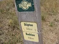
The trail has route markers every kilometre, to the next town and to the end of the trail. The surface is packed gravel, a road bike is probably unsuitable, but an urban or hybrid bike will be fine. There are shelters provided at regular intervals.
Prepare
You'll mostly need a bike or a horse depending on how you'll want to do this route, and some water. Note that you cannot do this trail in a motor vehicle.
Get in
If you wanted to get through the entire route then it's best to start at either Ballarat or Skipton, although there are numerous points along the way to get in if you wanted to do a shorter route.
Go

From Ballarat follow Gregory St to the north of Lake Wendouree onto Ring Rd. Gregory St is quiet, and there is a cycle path following the last sections of Gregory St and Ring Rd to the 🌍 start of the trail.
The railtrail itself starts in the outskirts of 🌍 Ballarat immediately south of the Ring Rd railway crossing.
- 🌍 Lake Wendouree to Haddon (10.3km). Agricultural country. Golden plains stretching into the distance. This part of the trip is largely flat. There are toilets and water in Haddon right on the railtrail, next to the recreation ground. There are no other supplies available.
- 🌍 Haddon to Smythesdale (7.3km). General store, pub, toilets and water in Smythesdale. The Courthouse hotel serves lunch and dinner 7-days, and
- 🌍 Smythesdale to Scarsdale (3.7km). General store, pub, toilets and water in Scarsdale. The pub serves dinner 7-days, and lunch on Saturdays and Sundays.

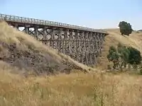
- 🌍 Scarsdale to Linton (12.9). This is the prettiest part of the trip, but also the hardest work. Just out of Scarsdale you will cross the 🌍 Nimmons Rail Bridge, a spectacular wooden trestle bridge, which has been restore so you can cycle over it, or use the track under it. After the bridge the track ascends through bushland, to an abandoned road bridge in the cutting, then you are rewarded with a cruise down through bushland and beside lakes and dams to Linton. Linton has a general store, milk bar, and petrol station for drinks and supplies right on the trail. If you ascend the hill into the town centre, you will find the pub, and not much else. Most of the rest of the town has all closed up.
- 🌍 Linton to Pittong (9.8km). There is no town at Pittong, but the neighbouring minerals factory has built a small lodge, which provides water, a shower, and toilets. This part of the ride is mostly downhill.
- 🌍 Pittong to 🌍 Skipton (10.6km). The trail follows closer to the road, and the landscape tends back towards the agricultural. At the end of the trail Skipton has a general store, a pub, toilets and water.