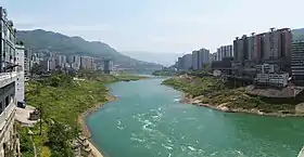
Wulong District
Wulong District (Chinese: 武隆区; pinyin: Wǔlóng Qū) is a district of Chongqing Municipality, China, bordering Guizhou province to the south.
Wulong
武隆区 | |
|---|---|
 | |
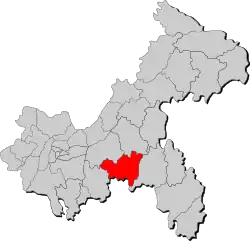 Location of Wulong in Chongqing | |
| Coordinates: 29°22′48″N 107°42′00″E | |
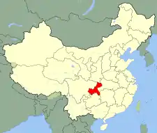
| Country | People's Republic of China |
| Municipality | Chongqing |
| Area | |
| • Total | 2,872 km2 (1,109 sq mi) |
| Population (2010) | |
| • Total | 351,000 |
| • Density | 120/km2 (320/sq mi) |
| Time zone | UTC+8 (China Standard) |
Administration
| Name | Chinese (S) | Hanyu Pinyin | Population (2010)[1] | Area (km2) |
|---|---|---|---|---|
| Huolu town | 火炉镇 | Huǒlú Zhèn | 25,818 | 184.1 |
| Xiangkou town | 巷口镇 | Xiàngkǒu Zhèn | 78,225 | 163.1 |
| Baima town | 白马镇 | Báimǎ Zhèn | 25,629 | 139.1 |
| Yajiang town | 鸭江镇 | Yājiāng Zhèn | 19,636 | 120.7 |
| Changba town | 长坝镇 | Chángbà Zhèn | 15,286 | 86 |
| Jiangkou town | 江口镇 | Jiāngkǒu Zhèn | 20,829 | 92.3 |
| Pingqiao town | 平桥镇 | Píngqiáo Zhèn | 14,926 | 73.4 |
| Yangjiao town | 羊角镇 | Yángjiǎo Zhèn | 14,659 | 69.9 |
| Xiannüshan town | 仙女山镇 | Xiānnǚshān Zhèn | 13,808 | 278 |
| Tongzi town | 桐梓镇 | Tóngzǐ Zhèn | 8,896 | 41.3 |
| Tukan town | 土坎镇 | Tǔkǎn Zhèn | 8,128 | 41.3 |
| Heshun town | 和顺镇 | Héshùn Zhèn | 11,899 | 103.2 |
| Shuanghe town | 双河镇 | Shuānghé Zhèn | 9,826 | 132 |
| Fenglai Township | 凤来乡 | Fènglái Xiāng | 11,036 | 52.3 |
| Miaoya Township | 庙垭乡 | Miàoyā Xiāng | 8,752 | 35.9 |
| Shiqiao Township | 石桥乡 | Shíqiáo Xiāng | 8,151 | 61.7 |
| Huangying Township | 黄莺乡 | Huángyīng Xiāng | 7,955 | 64 |
| Canggou Township | 沧沟乡 | Cānggōu Xiāng | 8,497 | 73 |
| Wenfu Township | 文复乡 | Wénfù Xiāng | 6,926 | 105.5 |
| Tudi Township | 土地乡 | Tǔdì Xiāng | 5,433 | 75.8 |
| Baiyun Township | 白云乡 | Báiyún Xiāng | 5,457 | 40.1 |
| Houping Township | 后坪乡 | Hòupíng Xiāng | 4,853 | 48.5 |
| Haokou Township | 浩口乡 | Hàokǒu Xiāng | 5,475 | 61 |
| Jielong Township | 接龙乡 | Jiēlóng Xiāng | 4,112 | 111.4 |
| Zhaojia Township | 赵家乡 | Zhàojiā Xiāng | 3,616 | 60.2 |
| Dadonghe Township | 大洞河乡 | Dàdònghé Xiāng | 3,210 | 62.7 |
Climate
| Climate data for Wulong (1993–2015 normals, extremes 1981–2010) | |||||||||||||
|---|---|---|---|---|---|---|---|---|---|---|---|---|---|
| Month | Jan | Feb | Mar | Apr | May | Jun | Jul | Aug | Sep | Oct | Nov | Dec | Year |
| Record high °C (°F) | 23.1 (73.6) |
30.0 (86.0) |
33.6 (92.5) |
36.8 (98.2) |
37.0 (98.6) |
39.8 (103.6) |
40.8 (105.4) |
42.7 (108.9) |
41.1 (106.0) |
35.7 (96.3) |
28.3 (82.9) |
20.2 (68.4) |
42.7 (108.9) |
| Average high °C (°F) | 10.5 (50.9) |
13.0 (55.4) |
18.0 (64.4) |
23.4 (74.1) |
26.9 (80.4) |
29.6 (85.3) |
33.4 (92.1) |
33.4 (92.1) |
28.8 (83.8) |
22.5 (72.5) |
17.5 (63.5) |
11.9 (53.4) |
22.4 (72.3) |
| Daily mean °C (°F) | 7.2 (45.0) |
9.4 (48.9) |
13.2 (55.8) |
17.8 (64.0) |
21.4 (70.5) |
24.4 (75.9) |
27.5 (81.5) |
27.1 (80.8) |
23.4 (74.1) |
18.3 (64.9) |
13.8 (56.8) |
8.7 (47.7) |
17.7 (63.8) |
| Average low °C (°F) | 5.0 (41.0) |
7.0 (44.6) |
10.0 (50.0) |
14.3 (57.7) |
17.8 (64.0) |
21.1 (70.0) |
23.6 (74.5) |
23.1 (73.6) |
20.0 (68.0) |
15.8 (60.4) |
11.5 (52.7) |
6.6 (43.9) |
14.7 (58.4) |
| Record low °C (°F) | −1.8 (28.8) |
−0.8 (30.6) |
1.4 (34.5) |
6.3 (43.3) |
11.4 (52.5) |
14.6 (58.3) |
18.3 (64.9) |
18.0 (64.4) |
11.7 (53.1) |
6.5 (43.7) |
0.9 (33.6) |
−1.5 (29.3) |
−1.8 (28.8) |
| Average precipitation mm (inches) | 15.8 (0.62) |
23.7 (0.93) |
46.7 (1.84) |
99.7 (3.93) |
144.5 (5.69) |
161.8 (6.37) |
150.5 (5.93) |
127.6 (5.02) |
98.8 (3.89) |
89.8 (3.54) |
48.5 (1.91) |
16.3 (0.64) |
1,023.7 (40.31) |
| Average precipitation days (≥ 0.1 mm) | 9.6 | 9.1 | 11.8 | 15.0 | 16.9 | 16.0 | 13.7 | 13.0 | 11.5 | 15.3 | 12.0 | 9.7 | 153.6 |
| Average snowy days | 0.7 | 0.2 | 0 | 0 | 0 | 0 | 0 | 0 | 0 | 0 | 0 | 0.2 | 1.1 |
| Average relative humidity (%) | 79 | 77 | 76 | 79 | 81 | 82 | 78 | 77 | 80 | 85 | 85 | 82 | 80 |
| Mean monthly sunshine hours | 34.4 | 32.7 | 71.9 | 97.6 | 112.5 | 108.4 | 177.6 | 183.2 | 116.3 | 68.4 | 51.2 | 36.8 | 1,091 |
| Percent possible sunshine | 11 | 10 | 19 | 25 | 27 | 26 | 42 | 45 | 32 | 20 | 16 | 12 | 24 |
| Source: China Meteorological Administration[2][3] | |||||||||||||
Education
There is a central elementary school in Baiyun Town.[4]
Transportation
The district is served by Chongqing Xiannvshan Airport which opened in December 2020.
World Heritage Site

Xiannüshan Town
Numerous Wulong Karst limestone rock formations are scenic landmarks in Wulong. They are protected within the UNESCO South China Karst World Heritage Site.
Features
- Three Natural Bridges — in Xiannüshan Town.
- Furong Cave —on the Furong River.
- Er Wang Dong — in Houping Miao and Tuzi Ethnic Township.
References
- shi, Guo wu yuan ren kou pu cha ban gong; council, Guo jia tong ji ju ren kou he jiu ye tong ji si bian = Tabulation on the 2010 population census of the people's republic of China by township / compiled by Population census office under the state; population, Department of; statistics, employment statistics national bureau of (2012). Zhongguo 2010 nian ren kou pu cha fen xiang, zhen, jie dao zi liao (Di 1 ban. ed.). Beijing Shi: Zhongguo tong ji chu ban she. ISBN 978-7-5037-6660-2.
- 中国气象数据网 – WeatherBk Data (in Simplified Chinese). China Meteorological Administration. Retrieved 28 April 2023.
- 中国气象数据网 (in Simplified Chinese). China Meteorological Administration. Retrieved 28 April 2023.
- Fan, Feifei (2013-08-20). "Rural boarding schools need dorm managers". China Daily. Retrieved 2018-12-05.
External links
Wikimedia Commons has media related to Wulong District.
Look up Wulong in Wiktionary, the free dictionary.
 Media related to South China Karst at Wikimedia Commons

This article is issued from Wikipedia. The text is licensed under Creative Commons - Attribution - Sharealike. Additional terms may apply for the media files.