Wisconsin Highway 108
State Trunk Highway 108 (often called Highway 108, STH-108 or WIS 108) is a state highway in the U.S. state of Wisconsin. It runs in west central Wisconsin from Wisconsin Highway 16 north of West Salem to Wisconsin Highway 54 and Wisconsin Highway 71 in Melrose. Highway 108 is maintained by the Wisconsin Department of Transportation.
State Trunk Highway 108 | ||||
|---|---|---|---|---|
WIS 108 highlighted in red | ||||
| Route information | ||||
| Maintained by WisDOT | ||||
| Length | 19.08 mi[1] (30.71 km) | |||
| Major junctions | ||||
| South end | ||||
| North end | ||||
| Location | ||||
| Country | United States | |||
| State | Wisconsin | |||
| Counties | La Crosse, Jackson | |||
| Highway system | ||||
| ||||
Route description

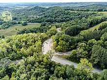
WIS 108 begins at a junction with WIS 16 in the Town of Hamilton in La Crosse County, just north of the border of West Salem. The highway heads northeast along a brief concurrency with County Trunk Highway C (CTH-C), then runs east for a short distance before heading north. From here, the route passes through a rural area and climbs a winding ridge.

Past the ridge, WIS 108 continues north, intersecting two county highways and crossing Fleming Creek. It turns northeast briefly before continuing north, where it intersects with another two county highways. The highway continues east briefly where it meets CTH-C before curving to the northeast. It then crosses Davis Creek before entering Jackson County.[1] In Jackson County, the route passes Melrose-Mindoro High School before heading north through the Town of Melrose. WIS 108 meets WIS 71 in the town, and the two highways continue northward together. The highways cross the Black River and continue north into the village of Melrose. Both highways terminate at a junction with WIS 54 in southern Melrose.
Major intersections
| County | Location | mi | km | Destinations | Notes |
|---|---|---|---|---|---|
| La Crosse | Town of Hamilton | 0.0 | 0.0 | Southern terminus | |
| Jackson | Town of Melrose | 17.8 | 28.6 | ||
| Melrose | 19.2 | 30.9 | Northern terminus | ||
1.000 mi = 1.609 km; 1.000 km = 0.621 mi
| |||||
See also
References
- Bessert, Chris. "Wisconsin Highways: Highways 100-109 (Highway 108)". Wisconsin Highways. Retrieved 2007-03-20.
External links
 Media related to Wisconsin Highway 108 at Wikimedia Commons
