West End Lane
West End Lane is a street in London, England that runs between Kilburn High Road to the west and Finchley Road to the east. Located in the London Borough of Camden, the street winds through West Hampstead with a mix of residential and commercial buildings. The three West Hampstead stations are all located on the road at the centre of the district of that name. In the east it today becomes Frognal Lane, although this stretch was once included as part of West End Lane.[1] It also marks the western boundary of South Hampstead. It is not connected to the West End of Central London, located several miles to the south.
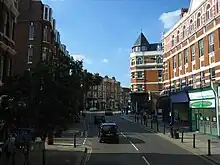

The lane takes its name from the Medieval West End hamlet, built on land belonging to Kilburn Priory, denoting the western extent of Hampstead.[2] [3] In the nineteenth century the once rural area was gradually merged into the expanding London suburbs. The first station at West Hampstead was opened in 1871, with two other routes adding stations before the end of the century as it become a popular location for commuters. Most of the buildings date from the late nineteenth century onwards, with a number of Edwardian redbrick mansion blocks and interwar art deco apartment buildings. West End Green is located on the street north of West Hampstead, just as it turns towards Frognal.
The North London Railway's West Hampstead stop was known as West End Lane station until 1975

See also
- North End Way, equivalent road marking the northern border of Hampstead
References
Bibliography
- Bebbington, Gillian. London Street Names. Batsford, 1972.
- Cockburn, J. S., King, H. P. F. & McDonnell, K. G. T. & A History of the County of Middlesex. Institute of Historical Research, 1989.
- Cherry, Bridget & Pevsner, Nikolaus. London 3: North West. Yale University Press, 2002.