Warrior Formation
The Cambrian Warrior Formation is a mapped limestone bedrock unit in Pennsylvania.
| Warrior Formation | |
|---|---|
| Stratigraphic range: Cambrian | |
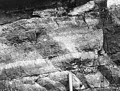
 Outcrop showing cryptozoa layers at Bakers Summit, Bedford County | |
| Type | sedimentary |
| Underlies | Gatesburg Formation |
| Overlies | Pleasant Hill Formation |
| Thickness | 250 ft at type sections,[1] 1350 ft in Nittany Arch,[2] 746 ft at Waddle.[3] |
| Lithology | |
| Primary | limestone |
| Other | shale, siltstone, sandstone |
| Location | |
| Region | Appalachian Basin |
| Country | United States |
| Extent | Bedford Co., Blair Co., Centre Co., Huntingdon Co.[4] |
| Type section | |
| Named for | Warrior Run, Blair County |
| Named by | C. Butts, 1918[1] |
Description
The Warrior Formation is described by Berg and others as gray, thin- to medium-bedded, fossiliferous, cyclic limestone bearing stromatolites, interbedded with shale, siltstone, and sandstone.[5]
Fossils

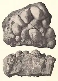
Cryptozoon undulatum from Bakers Summit
- Trilobites,[1] including Crepicephalus, Cedaria, Llanoaspidella,[3] and Blountia kindlei Resser, Coosella brevis Resser, Kingstonia ara (Walcott), K. kindlei Resser, and other Kingstonia species, Menomonia avitas (Walcott), Blountia, Modocia, Lonchocephalus, Genevievella, Pemphigaspis.[6]
- Brachiopods[3]
- Cryptozoon, a type of trace fossil[1][6]
- Stromatolites[5]
Notable Exposures
- Type section: Warrior Run, 1 mile east of Williamsburg, Blair County
- Warrior Creek (formerly Warriorsmark Creek), east of Warriors Mark, Huntingdon County
- Section near Waddle, Pennsylvania.[3]
Age
Relative age dating places the Warrior Formation in the middle to late Cambrian.
References
- Butts, Charles, 1918, Geologic section of Blair and Huntingdon Counties, central Pennsylvania: American Journal of Science, 4th series, v. 46, p. 523-537.
- Wilson, J.L., 1952, Upper Cambrian stratigraphy in the central Appalachians: Geological Society of America Bulletin, v. 63, no. 3, p. 275-322.
- Tasch, Paul, 1951, Fauna and Paleoecology of the Upper Cambrian Warrior Formation of Central Pennsylvania, Journal of Paleontology, Vol. 25, No. 3, pp. 275-306, pls. 44-47, May 1951 abstract
- USGS Mineral Resources On-Line Spatial Data, retrieved 4 Mar. 2011
- Berg, T.M. (compiler), 1980, Geologic map of Pennsylvania: Pennsylvania Geological Survey State Map, 4th series, 1, 1 sheet, scale 1:250,000
- Charles Butts, 1945. Hollidaysburg-Huntingdon folio, Pennsylvania, Folios of the Geologic Atlas 227. United States Geological Survey.
This article is issued from Wikipedia. The text is licensed under Creative Commons - Attribution - Sharealike. Additional terms may apply for the media files.