Waitoki
Waitoki is a locality in the Rodney District of New Zealand. Wainui is approximately 5.5 kilometres to the north-east, Kaukapakapa 6.5 km to the north-west, and Dairy Flat 10 km to the south-east. The Wainui Stream joins the Waitoki Stream just to the north-east of the locality. The stream flows west into the Kaukapakapa River.[1][2]
Waitoki | |
|---|---|
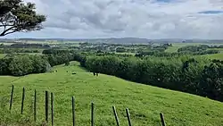 Farmland near Waitoki in Northern Auckland Region | |
| Coordinates: 36°38′5″S 174°33′5″E | |
| Country | New Zealand |
| Region | Auckland Region |
| Ward | Rodney ward |
| Community board | Rodney Local Board |
| Electorates | |
| Government | |
| • Territorial Authority | Auckland Council |
Demographics
Waitoki statistical area covers 40.76 km2 (15.74 sq mi) south and east of the settlement[3] and had an estimated population of 1,750 as of June 2022,[4] with a population density of 43 people per km2.
| Year | Pop. | ±% p.a. |
|---|---|---|
| 2006 | 1,278 | — |
| 2013 | 1,320 | +0.46% |
| 2018 | 1,530 | +3.00% |
| Source: [5] | ||
Waitoki had a population of 1,530 at the 2018 New Zealand census, an increase of 210 people (15.9%) since the 2013 census, and an increase of 252 people (19.7%) since the 2006 census. There were 507 households, comprising 762 males and 768 females, giving a sex ratio of 0.99 males per female. The median age was 42.8 years (compared with 37.4 years nationally), with 300 people (19.6%) aged under 15 years, 303 (19.8%) aged 15 to 29, 750 (49.0%) aged 30 to 64, and 177 (11.6%) aged 65 or older.
Ethnicities were 94.1% European/Pākehā, 7.5% Māori, 1.2% Pacific peoples, 3.1% Asian, and 1.6% other ethnicities. People may identify with more than one ethnicity.
The percentage of people born overseas was 23.7, compared with 27.1% nationally.
Although some people chose not to answer the census's question about religious affiliation, 59.2% had no religion, 30.2% were Christian, 0.2% were Hindu, 0.4% were Buddhist and 2.4% had other religions.
Of those at least 15 years old, 273 (22.2%) people had a bachelor's or higher degree, and 153 (12.4%) people had no formal qualifications. The median income was $42,500, compared with $31,800 nationally. 348 people (28.3%) earned over $70,000 compared to 17.2% nationally. The employment status of those at least 15 was that 654 (53.2%) people were employed full-time, 252 (20.5%) were part-time, and 27 (2.2%) were unemployed.[5]
Education
Waitoki School is a coeducational full primary (years 1-8) school with a roll of 165 students as of April 2023.[6][7] The school opened in 1924[8] and celebrated its 75th anniversary in 1999.[9]
Notes
- Peter Dowling, ed. (2004). Reed New Zealand Atlas. Reed Books. pp. map 11. ISBN 0-7900-0952-8.
- Roger Smith, GeographX (2005). The Geographic Atlas of New Zealand. Robbie Burton. pp. map 35. ISBN 1-877333-20-4.
- "ArcGIS Web Application". statsnz.maps.arcgis.com. Retrieved 29 May 2022.
- "Population estimate tables - NZ.Stat". Statistics New Zealand. Retrieved 25 October 2022.
- "Statistical area 1 dataset for 2018 Census". Statistics New Zealand. March 2020. Waitoki (112500). 2018 Census place summary: Waitoki
- "New Zealand Schools Directory". New Zealand Ministry of Education. Retrieved 12 December 2022.
- Education Counts: Waitoki School
- "Waitoki School History - Early History". Waitoki School. Retrieved 8 October 2008.
- "Jubilees & reunions - Waitoki School". Education Gazette New Zealand. 78 (12). 19 July 1999. Retrieved 8 October 2008.